


LONLAYE 20K

UDGI54
User
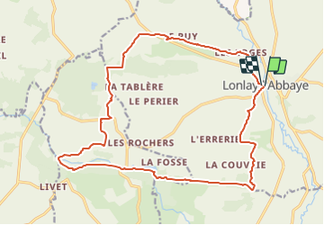

Length
20 km

Max alt
276 m

Uphill gradient
404 m
Km-Effort
26 km

Min alt
140 m

Downhill gradient
405 m
Boucle
Yes
Creation date :
2021-07-23 12:16:02.374
Updated on :
2021-07-23 12:16:48.207
5h49
Difficulty : Very difficult

FREE GPS app for hiking
 SityTrail
IGN / Geographical institutes
SityTrail Plus
The world is yours!
About
Trail Walking of 20 km to be discovered at Normandy, Orne, Lonlay-l'Abbaye. This trail is proposed by UDGI54.
Positioning
Country:
France
Region :
Normandy
Department/Province :
Orne
Municipality :
Lonlay-l'Abbaye
Location:
Unknown
Start:(Dec)
Start:(UTM)
668659 ; 5390592 (30U) N.
Comments