Trail Walking Solutré-Pouilly - Roche de Solutré 4km - Photo
 thonyc
thonyc

User GUIDE

© OpenStreetMap contributors
Length
Length
3.7 km
Max alt
Max alt
464 m
Uphill gradient
Uphill gradient
128 m
Km-Effort
Km-Effort  
5.5 km
Min alt
Min alt
368 m
Downhill gradient
Downhill gradient
130 m
Boucle
Boucle
Yes
Creation date :
2021-09-07 06:44:38.462
Updated on :
2021-11-21 08:11:05.843

(1 Reviews)

Walking
Walking
2h00
Difficulty : Easy

Scan this QR Code to open this trail in the SityTrail application

FREE GPS app for hiking

Logo SityTrail SityTrail

IGN / Geographical institutes

Download SityTrail from the App Store Download SityTrail from Google Play

Logo SityTrail SityTrail World

The world is yours!

Download SityTrail from the App Store Download SityTrail from Google Play Download SityTrail on Huawei AppGallery

About

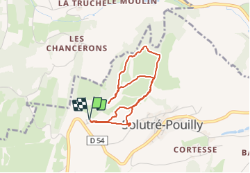
Trail Walking of 3.7 km to be discovered at Bourgogne-Franche-Comté, Saône-et-Loire, Solutré-Pouilly. This trail is proposed by thonyc.

Description

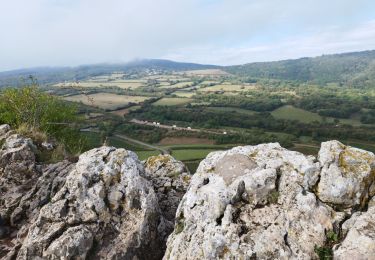
Très beaux panoramas sur les Roches de Solutré et de Vergisson, ainsi que sur la plaine vinicole du Macônnais

Elevation profile

Photos

Positioning

Country:
France
Region :
Bourgogne-Franche-Comté
Department/Province :
Saône-et-Loire
Municipality :
Solutré-Pouilly
Location:
Unknown
Start:(UTM)
632143 ; 5128515 (31T) N.

Comments

Please log in to post a review or rate the element


Trails nearby

Trail Mountain bike Serrières - RTT 2015 SAMEDI - Photo
Mountain bike
Tollard

Mountain bike

Difficult
(2)
Serrières, Bourgogne-Franche-Comté, Saône-et-Loire, France
66 km | 98 km-effort
6h 7min
Yes
Trail Walking Pierreclos - Chateau de Pierreclos - Bourgogne - Aout 2012 - Photo
Walking
patrickmarchais

Walking

Easy
(1)
Pierreclos, Bourgogne-Franche-Comté, Saône-et-Loire, France
18.4 km | 26 km-effort
4h 39min
Yes
Trail Walking Solutré-Pouilly - La roche de Solutré  - Photo
Walking
alainjoseph6

Walking

Easy
Solutré-Pouilly, Bourgogne-Franche-Comté, Saône-et-Loire, France
3.4 km | 4.8 km-effort
1h 17min
Yes
Trail Walking Davayé - Roche de solutré - Photo
Walking
yves62410

Walking

Difficult
Davayé, Bourgogne-Franche-Comté, Saône-et-Loire, France
10.5 km | 16.5 km-effort
3h 54min
Yes
Trail Walking Leynes - LEYNES 71 - Photo
Walking
janussity

Walking

Difficult
Leynes, Bourgogne-Franche-Comté, Saône-et-Loire, France
9.5 km | 12.7 km-effort
2h 38min
Yes
Trail Walking Saint-Vérand - St Vérand - Photo
Walking
JPA GRS

Walking

Medium
(1)
Saint-Vérand, Bourgogne-Franche-Comté, Saône-et-Loire, France
9.8 km | 12.6 km-effort
2h 0min
Yes
Trail Walking Vinzelles - Vinzelles - Photo
Walking
janussity

Walking

Easy
(1)
Vinzelles, Bourgogne-Franche-Comté, Saône-et-Loire, France
7.8 km | 10.1 km-effort
2h 6min
Yes
Trail Walking Cenves - Séjour RCY Les crêtes du Haut Beaujolais journée 2 - Photo
Walking
chessyca

Walking

Very difficult
Cenves, Auvergne-Rhône-Alpes, Rhône, France
27 km | 40 km-effort
6h 53min
No
Trail Walking Mâcon - Sejour RCY : Les crêtes du Haut Beaujolais journée 1 - Photo
Walking
chessyca

Walking

Very difficult
Mâcon, Bourgogne-Franche-Comté, Saône-et-Loire, France
23 km | 35 km-effort
5h 57min
No


Close
My subscriptions