Trail Running Puycapel - Mourjou Châtaigne 2013  - Photo

Mourjou Châtaigne 2013

 tracegps
tracegps

User

© OpenStreetMap contributors
Length
Length
11.6 km
Max alt
Max alt
508 m
Uphill gradient
Uphill gradient
484 m
Km-Effort
Km-Effort  
18 km
Min alt
Min alt
359 m
Downhill gradient
Downhill gradient
482 m
Boucle
Boucle
Yes
Creation date :
2014-12-10 00:00:00.0
Updated on :
2014-12-10 00:00:00.0

(0 Reviews)

Running
Running
2h00
Difficulty : Difficult

Scan this QR Code to open this trail in the SityTrail application

FREE GPS app for hiking

Logo SityTrail SityTrail

IGN / Geographical institutes

Download SityTrail from the App Store Download SityTrail from Google Play

Logo SityTrail SityTrail World

The world is yours!

Download SityTrail from the App Store Download SityTrail from Google Play Download SityTrail on Huawei AppGallery

About

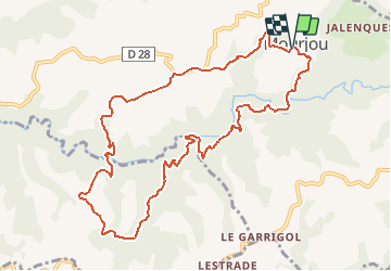
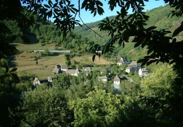
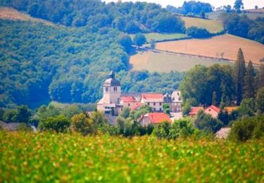
Trail Running of 11.6 km to be discovered at Auvergne-Rhône-Alpes, Cantal, Puycapel. This trail is proposed by tracegps.

Description

Très beau parcours boisé et sauvage. Passage privé avant le lieu dit Labro.

Elevation profile

Photos

Positioning

Country:
France
Region :
Auvergne-Rhône-Alpes
Department/Province :
Cantal
Municipality :
Puycapel
Location:
Unknown
Start:(UTM)
446895 ; 4948824 (31T) N.

Trails nearby

Trail Mountain bike Puycapel - Dans les bois de Calvinet - La Roubine - Photo
Mountain bike
tracegps

Mountain bike

Medium
(1)
Puycapel, Auvergne-Rhône-Alpes, Cantal, France
24 km | 32 km-effort
2h 30min
Yes
Trail Walking Puycapel - Mourjou Châtaigne 2013  - Photo
Walking
tracegps

Walking

Medium
Puycapel, Auvergne-Rhône-Alpes, Cantal, France
11.6 km | 18 km-effort
2h 10min
Yes
Trail Walking Cassaniouze - cassaniouze st projet  - Photo
Walking
Sandrine 15

Walking

Very difficult
Cassaniouze, Auvergne-Rhône-Alpes, Cantal, France
13.6 km | 22 km-effort
2h 39min
Yes
Trail Walking Cassaniouze - cassaniouze st projet - Photo
Walking
yves12

Walking

Medium
Cassaniouze, Auvergne-Rhône-Alpes, Cantal, France
15.2 km | 24 km-effort
3h 52min
Yes
Trail Walking Cassaniouze - Cassaniouze - St Projet - Le chateau de Roquemaurel - Photo
Walking
tracegps

Walking

Difficult
Cassaniouze, Auvergne-Rhône-Alpes, Cantal, France
15.6 km | 26 km-effort
4h 0min
Yes
Trail Running Puycapel - Autour de Mourjou - Photo
Running
tracegps

Running

Medium
Puycapel, Auvergne-Rhône-Alpes, Cantal, France
19.5 km | 27 km-effort
2h 0min
No
Trail Walking Cassaniouze - Camping Le Cantalou  - Photo
Walking
agfa

Walking

Easy
Cassaniouze, Auvergne-Rhône-Alpes, Cantal, France
5.7 km | 6.9 km-effort
1h 15min
Yes
Trail Walking Cassaniouze - St Projet 12 - Photo
Walking
gcournac

Walking

Very difficult
Cassaniouze, Auvergne-Rhône-Alpes, Cantal, France
15.8 km | 26 km-effort
4h 55min
Yes
Trail Walking Puycapel - Mourjou en Châtaigneraie  - Photo
Walking
topophil

Walking

Easy
Puycapel, Auvergne-Rhône-Alpes, Cantal, France
4.8 km | 6 km-effort
2h 12min
Yes


Close
My subscriptions