Trail Walking Planès - étang de Planès - Photo
 fhascoet
fhascoet

User

© OpenStreetMap contributors
Length
Length
10.8 km
Max alt
Max alt
2200 m
Uphill gradient
Uphill gradient
665 m
Km-Effort
Km-Effort  
19.6 km
Min alt
Min alt
1535 m
Downhill gradient
Downhill gradient
666 m
Boucle
Boucle
No
Creation date :
2014-12-10 00:00:00.0
Updated on :
2014-12-10 00:00:00.0

(2 Reviews)

Walking
Walking
3h54
Difficulty : Medium

Scan this QR Code to open this trail in the SityTrail application

FREE GPS app for hiking

Logo SityTrail SityTrail

IGN / Geographical institutes

Download SityTrail from the App Store Download SityTrail from Google Play

Logo SityTrail SityTrail World

The world is yours!

Download SityTrail from the App Store Download SityTrail from Google Play Download SityTrail on Huawei AppGallery

About

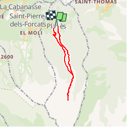
Trail Walking of 10.8 km to be discovered at Occitania, Pyrénées-Orientales, Planès. This trail is proposed by fhascoet.

Description

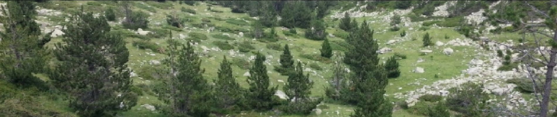
montée raide en foret.Aller retour vers l'étang facile et joli. retour agréable en foret

Elevation profile

Photos

Positioning

Country:
France
Region :
Occitania
Department/Province :
Pyrénées-Orientales
Municipality :
Planès
Location:
Unknown
Start:(UTM)
429200 ; 4704628 (31T) N.

Comments

Please log in to post a review or rate the element


Trails nearby

Trail Walking Eyne - Eyne,col de Nuria,pic d'Eyne,Torre d'Eyne,Eyne. - Photo
Walking
Machaon6

Walking

Very difficult
(1)
Eyne, Occitania, Pyrénées-Orientales, France
24 km | 43 km-effort
8h 44min
Yes
Trail Walking Fontpédrouse - Tour du Cucurucull - Photo
Walking
Pek56

Walking

Medium
(1)
Fontpédrouse, Occitania, Pyrénées-Orientales, France
9.3 km | 18.5 km-effort
3h 24min
Yes
Trail Walking Fontpédrouse - fontpérouse sentier des canaux et sources chaudes naturelles_T - Photo
Walking
force

Walking

Medium
(1)
Fontpédrouse, Occitania, Pyrénées-Orientales, France
13.7 km | 25 km-effort
5h 9min
Yes
Trail Walking Eyne - Le Cambre d'Ase - Photo
Walking
tracegps

Walking

Difficult
(1)
Eyne, Occitania, Pyrénées-Orientales, France
8.9 km | 22 km-effort
4h 0min
Yes
Trail Walking Eyne - Vallée d'Eyne - Photo
Walking
GUIDE
nadinebondoux

Walking

Medium
Eyne, Occitania, Pyrénées-Orientales, France
10.7 km | 17.6 km-effort
4h 40min
Yes
Trail Walking Saint-Pierre-dels-Forcats - bains  de St Thomas  - Photo
Walking
Ptitjack30

Walking

Medium
(1)
Saint-Pierre-dels-Forcats, Occitania, Pyrénées-Orientales, France
8.6 km | 12.2 km-effort
2h 42min
No
Trail Walking La Llagonne - llagonne - Calvet - Photo
Walking
merencianoep

Walking

Medium
(2)
La Llagonne, Occitania, Pyrénées-Orientales, France
11.2 km | 14.2 km-effort
3h 0min
No
Trail Walking Eyne - eyne - Photo
Walking
gardelg

Walking

Medium
(2)
Eyne, Occitania, Pyrénées-Orientales, France
6.2 km | 8.2 km-effort
2h 1min
Yes
Trail Walking Eyne - La vallée d'Eyne - Photo
Walking
suresnois

Walking

Difficult
Eyne, Occitania, Pyrénées-Orientales, France
11.2 km | 18 km-effort
7h 8min
Yes


Close
My subscriptions