


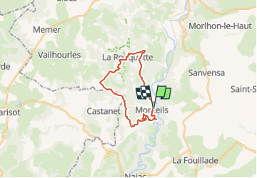

25 km | 33 km-effort


User


FREE GPS app for hiking
 SityTrail
IGN / Geographical institutes
SityTrail World
The world is yours!
Trail On foot of 21 km to be discovered at Occitania, Aveyron, Monteils. This trail is proposed by tercla.
Départ randonnée : Se garer juste avant le pont qui enjambe l’Assou, en venant de Villefranche, point de départ de la rando
Partir sur la route de Villefranche, direction Nord.Juste après la salle des Fêtes, se diriger vers la gauche.Peu avant Laumière, se diriger vers l’Ouest en direction du GR 36.Le traverser et descendre à La Rouquette par un sentier parfois très pentu.
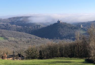
Beau point de vue sur le village, le château, l’église et son clocher peigne.Remonter en direction du plateau, où l’on peut dominer la vallée de l’Assou en longeant la corniche (petit sentier).On passe par le Mas de la Borie, la Nouaillé, St Gauzy.
Au milieu de la descente vers le moulin de Castanet sur votre droite à 50 mètres du chemin vous pourrez voir une très belle cazelle, qui vaut le détour.Au bas de la route qui monte aux Celles basses,vous prendrez sur votre gauche un sentier assez technique (abîmé par les motos) Arrivé à Bessanes,on rejoint le GR en passant par les Annilloux.Du GR36 on peut rejoindre Monteils, mais je vous recommande de le quitter pour faire un crochet qui vous fait passer 100 mètres avant Caylou
où vous aurez un beau point de vue sur le village et plus loin sur la vallée de l’Aveyron.
Road bike

Mountain bike
Mountain bike

Walking
Walking

Running
Walking
Mountain bike