![](/images/other/stat-length.png)
![Trail Walking Saint-Pierre-d'Albigny - Bauges Dent d’Arclusaz - Photo](https://media.geolcdn.com/t/1900/400/ext.pjpeg?maxdim=2&url=https%3A%2F%2Fstatic1.geolcdn.com%2Fsiteimages%2Fupload%2Ffiles%2F1553511878bg_sport_marche.png)
Bauges Dent d’Arclusaz
c.gourme
User
![Length](/images/other/stat-length.png)
Length
13.8 km
![Max alt](https://static1.geolcdn.com/siteimages/upload/files/1508320355ic_sort_altitude_max_24dp.png)
Max alt
2019 m
![Uphill gradient](https://static1.geolcdn.com/siteimages/upload/files/1508320355ic_sort_den_pos_24dp.png)
Uphill gradient
1119 m
![Km-Effort](/images/other/stat-length.png)
Km-Effort
29 km
![Min alt](https://static1.geolcdn.com/siteimages/upload/files/1508320355ic_sort_altitude_min_24dp.png)
Min alt
955 m
![Downhill gradient](https://static1.geolcdn.com/siteimages/upload/files/1508320355ic_sort_den_neg_24dp.png)
Downhill gradient
1116 m
![Boucle](https://static1.geolcdn.com/siteimages/upload/files/16400158638029165_repeat_loop_refresh_sync_direction_icon.png)
Boucle
Yes
Creation date :
2022-10-18 06:33:50.0
Updated on :
2022-10-21 05:06:38.249
![Walking](https://static1.geolcdn.com/sitytour/trail-icons/101.png)
6h14
Difficulty : Difficult
![Scan this QR Code to open this trail in the SityTrail application](https://capi.geolives.com/qq0zvz2zws4bq2lad0pu/sitytour/trails/3430344/qr.png?size=200)
FREE GPS app for hiking
About
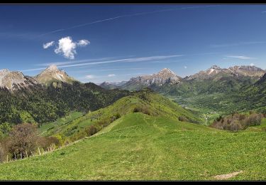
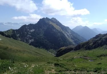
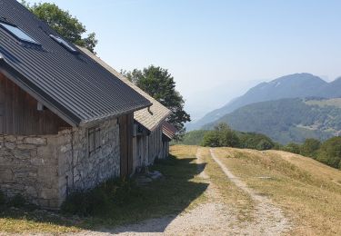
Trail Walking of 13.8 km to be discovered at Auvergne-Rhône-Alpes, Savoy, Saint-Pierre-d'Albigny. This trail is proposed by c.gourme.
Description
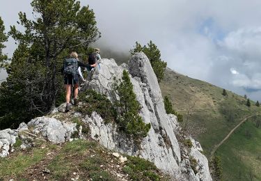
En approchant de la crête bien suivre les marques jaunes pour aboutir à la petite faille. À la descente utiliser les cables c’est beaucoup plus facile.
Positioning
Country:
France
Region :
Auvergne-Rhône-Alpes
Department/Province :
Savoy
Municipality :
Saint-Pierre-d'Albigny
Location:
Unknown
Start:(Dec)
Start:(UTM)
276566 ; 5051694 (32T) N.
Comments
Trails nearby
![Trail Walking Saint-Pierre-d'Albigny - La Dent d'Arclusaz, 2041m - Photo](https://media.geolcdn.com/t/375/260/ext.jpg?maxdim=2&url=https%3A%2F%2Fservices.sitytrail.com%2FGeolivesWS%2FDownloadMedia.ashx%3FTrailID%3D105785%26Media%3D9678_1.jpg)
![Walking Walking](https://static1.geolcdn.com/sitytour/trail-icons/101.png)
La Dent d'Arclusaz, 2041m
Walking
Difficult
(2)
Saint-Pierre-d'Albigny,
Auvergne-Rhône-Alpes,
Savoy,
France
![](/images/other/stat-length.png)
13.9 km | 29 km-effort
7h 30min
![](https://static1.geolcdn.com/siteimages/upload/files/16400158638029165_repeat_loop_refresh_sync_direction_icon.png)
Yes
![Trail Walking Aillon-le-Jeune - La Pointe de la Galoppaz 1680m, depuis le Col du Lindar - Photo](https://media.geolcdn.com/t/375/260/ext.jpg?maxdim=2&url=https%3A%2F%2Fservices.sitytrail.com%2FGeolivesWS%2FDownloadMedia.ashx%3FTrailID%3D103728%26Media%3D6391_1.jpg)
![Walking Walking](https://static1.geolcdn.com/sitytour/trail-icons/101.png)
La Pointe de la Galoppaz 1680m, depuis le Col du Lindar
Walking
Easy
(1)
Aillon-le-Jeune,
Auvergne-Rhône-Alpes,
Savoy,
France
![](/images/other/stat-length.png)
7.4 km | 14.9 km-effort
3h 45min
![](https://static1.geolcdn.com/siteimages/upload/files/16400158638029165_repeat_loop_refresh_sync_direction_icon.png)
No
![Trail Mountain bike La Thuile - Bauges - La vallée du Lindar - Photo](https://media.geolcdn.com/t/375/260/ext.jpg?maxdim=2&url=https%3A%2F%2Fservices.sitytrail.com%2FGeolivesWS%2FDownloadMedia.ashx%3FTrailID%3D102183%26Media%3D2575_1.jpg)
![Mountain bike Mountain bike](https://static1.geolcdn.com/sitytour/trail-icons/202.png)
Bauges - La vallée du Lindar
Mountain bike
Difficult
(1)
La Thuile,
Auvergne-Rhône-Alpes,
Savoy,
France
![](/images/other/stat-length.png)
18 km | 31 km-effort
3h 0min
![](https://static1.geolcdn.com/siteimages/upload/files/16400158638029165_repeat_loop_refresh_sync_direction_icon.png)
Yes
![Trail Walking Aillon-le-Jeune - Colombier par rocher de la Bade et Cochette, retour par la Fulie - Photo](https://media.geolcdn.com/t/375/260/ext.jpg?maxdim=2&url=https%3A%2F%2Fstatic1.geolcdn.com%2Fsiteimages%2Fupload%2Ffiles%2F1553511878bg_sport_marche.png)
![Walking Walking](https://static1.geolcdn.com/sitytour/trail-icons/101.png)
Colombier par rocher de la Bade et Cochette, retour par la Fulie
Walking
Very easy
(2)
Aillon-le-Jeune,
Auvergne-Rhône-Alpes,
Savoy,
France
![](/images/other/stat-length.png)
17.7 km | 35 km-effort
6h 4min
![](https://static1.geolcdn.com/siteimages/upload/files/16400158638029165_repeat_loop_refresh_sync_direction_icon.png)
Yes
![Trail Walking Aillon-le-Jeune - Petit circuit découverte aillon le jeune - Photo](https://media.geolcdn.com/t/375/260/ext.jpg?maxdim=2&url=https%3A%2F%2Fmedia.geolcdn.com%2Ff%2F9feb56d6-5072-42da-bdbc-71a62ee2fe47.jpg)
![Walking Walking](https://static1.geolcdn.com/sitytour/trail-icons/101.png)
Petit circuit découverte aillon le jeune
Walking
Very easy
Aillon-le-Jeune,
Auvergne-Rhône-Alpes,
Savoy,
France
![](/images/other/stat-length.png)
5.9 km | 8.9 km-effort
1h 59min
![](https://static1.geolcdn.com/siteimages/upload/files/16400158638029165_repeat_loop_refresh_sync_direction_icon.png)
Yes
![Trail Walking Aillon-le-Jeune - Mont Colombier par les rochers de la Bade et la sente de Rossanaz avec CAF Annecy -R3 - Photo](https://media.geolcdn.com/t/375/260/ext.jpg?maxdim=2&url=https%3A%2F%2Fmedia.geolcdn.com%2Ff%2F115caff0-3029-49ce-bb0e-6db480a7c5ad.jpeg)
![Walking Walking](https://static1.geolcdn.com/sitytour/trail-icons/101.png)
Mont Colombier par les rochers de la Bade et la sente de Rossanaz avec CAF An...
Walking
Very difficult
Aillon-le-Jeune,
Auvergne-Rhône-Alpes,
Savoy,
France
![](/images/other/stat-length.png)
12.2 km | 30 km-effort
6h 42min
![](https://static1.geolcdn.com/siteimages/upload/files/16400158638029165_repeat_loop_refresh_sync_direction_icon.png)
Yes
![Trail Walking Sainte-Reine - Mont Pelat - Photo](https://media.geolcdn.com/t/375/260/ext.jpg?maxdim=2&url=https%3A%2F%2Fmedia.geolcdn.com%2Ff%2F7f0ecbf2-604f-4efc-a503-ee88b8b0b343.jpg)
![Walking Walking](https://static1.geolcdn.com/sitytour/trail-icons/101.png)
Mont Pelat
Walking
Medium
Sainte-Reine,
Auvergne-Rhône-Alpes,
Savoy,
France
![](/images/other/stat-length.png)
15.5 km | 28 km-effort
4h 51min
![](https://static1.geolcdn.com/siteimages/upload/files/16400158638029165_repeat_loop_refresh_sync_direction_icon.png)
Yes
![Trail Walking Aillon-le-Jeune - Rochers de Barde - Photo](https://media.geolcdn.com/t/375/260/ext.jpg?maxdim=2&url=https%3A%2F%2Fmedia.geolcdn.com%2Ff%2F48940505-c84c-4f22-8bea-360415ea5442.jpg)
![Walking Walking](https://static1.geolcdn.com/sitytour/trail-icons/101.png)
Rochers de Barde
Walking
Medium
Aillon-le-Jeune,
Auvergne-Rhône-Alpes,
Savoy,
France
![](/images/other/stat-length.png)
11.7 km | 24 km-effort
6h 25min
![](https://static1.geolcdn.com/siteimages/upload/files/16400158638029165_repeat_loop_refresh_sync_direction_icon.png)
Yes
![Trail Walking Sainte-Reine - Routhennes - col du potat - Photo](https://media.geolcdn.com/t/375/260/ext.jpg?maxdim=2&url=https%3A%2F%2Fmedia.geolcdn.com%2Ff%2F65fed8de-b503-4ecb-aa1d-a1896419183d.jpg)
![Walking Walking](https://static1.geolcdn.com/sitytour/trail-icons/101.png)
Routhennes - col du potat
Walking
Medium
Sainte-Reine,
Auvergne-Rhône-Alpes,
Savoy,
France
![](/images/other/stat-length.png)
8.9 km | 16.6 km-effort
3h 42min
![](https://static1.geolcdn.com/siteimages/upload/files/16400158638029165_repeat_loop_refresh_sync_direction_icon.png)
Yes