Trail Walking Orbey - Les deux Lacs - Photo

Les deux Lacs

 helmut68
helmut68

User

© OpenStreetMap contributors
Length
Length
9.8 km
Max alt
Max alt
1304 m
Uphill gradient
Uphill gradient
395 m
Km-Effort
Km-Effort  
15.1 km
Min alt
Min alt
952 m
Downhill gradient
Downhill gradient
412 m
Boucle
Boucle
Yes
Creation date :
2022-11-11 09:49:30.568
Updated on :
2022-11-14 21:22:58.143

(0 Reviews)

Walking
Walking
4h27
Difficulty : Difficult

Scan this QR Code to open this trail in the SityTrail application

FREE GPS app for hiking

Logo SityTrail SityTrail

IGN / Geographical institutes

Download SityTrail from the App Store Download SityTrail from Google Play

Logo SityTrail SityTrail World

The world is yours!

Download SityTrail from the App Store Download SityTrail from Google Play Download SityTrail on Huawei AppGallery

About

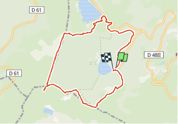
Trail Walking of 9.8 km to be discovered at Grand Est, Haut-Rhin, Orbey. This trail is proposed by helmut68.

Description

Départ de la rando au parking du Lac Noir , à quelques mètre rejoigner le sentier Cornélius puis suivez le GR532  " rectangle jaune " jusqu' au lac Blanc . A partir de là commence une montée difficile balisée " anneau rouge " jusqu' à la source du Lac Blanc . Ensuite sur environ 200 m emprunter le balisage " rectangle rouge blanc rouge " pour  arriver sur le Gazon du Faing   GR5 "  rectangle rouge " . Après environ un kilomètre de sentier avec des points de vues exceptionnelles ( plateau Lorrain et Vosges... ) tourner à gauche en suivant le balisage " triangle jaune " jusqu'au Altenkraehkopf . A partir de là emprunter le sentier non blaisé sur votre gauche jusqu'au lac Noir .
Alors à vos chaussures !

Elevation profile

Photos

Positioning

Country:
France
Region :
Grand Est
Department/Province :
Haut-Rhin
Municipality :
Orbey
Location:
Unknown
Start:(UTM)
358644 ; 5330580 (32U) N.

Trails nearby

Trail Horseback riding Orbey - 2020-06-28 WE Orbey Petit Hohnack Glasborn - Photo
Horseback riding
GUIDE
holtzv

Horseback riding

Difficult
(1)
Orbey, Grand Est, Haut-Rhin, France
22 km | 31 km-effort
4h 5min
Yes
Trail Horseback riding Orbey - 2020-06-27 WE Orbey Noir Gazon Vert Forlet - Photo
Horseback riding
GUIDE
holtzv

Horseback riding

Medium
(1)
Orbey, Grand Est, Haut-Rhin, France
21 km | 30 km-effort
3h 59min
Yes
Trail Walking Stosswihr - Tour du belvedere avec le passage sur les crêtes  - Photo
Walking
ocepee

Walking

Very easy
(2)
Stosswihr, Grand Est, Haut-Rhin, France
8.5 km | 0 m-effort
2h 28min
Yes
Trail Other activity Soultzeren - Totom 4 lacs - Photo
Other activity
dinozore

Other activity

Medium
(1)
Soultzeren, Grand Est, Haut-Rhin, France
15.6 km | 26 km-effort
4h 37min
Yes
Trail Walking Orbey - Le Tour du Lac Blanc par le Rocher Hans et le sentier de crête - Photo
Walking
tracegps

Walking

Difficult
(3)
Orbey, Grand Est, Haut-Rhin, France
4.4 km | 7.7 km-effort
2h 30min
Yes
Trail Walking Le Bonhomme - Tête des faux . - Photo
Walking
heurtinpatrick

Walking

Medium
(1)
Le Bonhomme, Grand Est, Haut-Rhin, France
11.9 km | 16.6 km-effort
3h 46min
Yes
Trail Walking Soultzeren - Tanet-Gazon du faing par lac vert et retour sommet du Tanet - Photo
Walking
ride-in-Elsass

Walking

Medium
(1)
Soultzeren, Grand Est, Haut-Rhin, France
10 km | 15.6 km-effort
4h 24min
Yes
Trail Walking Lapoutroie - 2012-06-16 Marche aux Alisiers Orbey - Photo
Walking
GUIDE
holtzv

Walking

Easy
(2)
Lapoutroie, Grand Est, Haut-Rhin, France
11.1 km | 16.6 km-effort
2h 49min
Yes
Trail Mountain bike Orbey - Lac Blanc  - Têtes des Faux - Photo
Mountain bike
tracegps

Mountain bike

Medium
(1)
Orbey, Grand Est, Haut-Rhin, France
15.3 km | 21 km-effort
1h 0min
Yes


Close
My subscriptions