Trail Walking Cour-et-Buis - 38-Cour-et-Buis-Eyzin-restau-18km-420mdec22 - Photo

38-Cour-et-Buis-Eyzin-restau-18km-420mdec22

 SyMA
SyMA

User

© OpenStreetMap contributors
Length
Length
20 km
Max alt
Max alt
455 m
Uphill gradient
Uphill gradient
416 m
Km-Effort
Km-Effort  
26 km
Min alt
Min alt
250 m
Downhill gradient
Downhill gradient
416 m
Boucle
Boucle
Yes
Creation date :
2022-12-01 08:04:28.121
Updated on :
2022-12-05 09:30:13.005

(1 Reviews)

Walking
Walking
5h41
Difficulty : Medium

Scan this QR Code to open this trail in the SityTrail application

FREE GPS app for hiking

Logo SityTrail SityTrail

IGN / Geographical institutes

Download SityTrail from the App Store Download SityTrail from Google Play

Logo SityTrail SityTrail World

The world is yours!

Download SityTrail from the App Store Download SityTrail from Google Play Download SityTrail on Huawei AppGallery

About

Trail Walking of 20 km to be discovered at Auvergne-Rhône-Alpes, Isère, Cour-et-Buis. This trail is proposed by SyMA.

Description

Restau cocotte EYZIN    
Départ terrain de sport de Cour et Buis

Elevation profile

Photos

Positioning

Country:
France
Region :
Auvergne-Rhône-Alpes
Department/Province :
Isère
Municipality :
Cour-et-Buis
Location:
Unknown
Start:(UTM)
656957 ; 5033896 (31T) N.

Comments

Please log in to post a review or rate the element


Trails nearby

Trail Mountain bike Monsteroux-Milieu - sanglier - Photo
Mountain bike
phusser

Mountain bike

Very easy
(1)
Monsteroux-Milieu, Auvergne-Rhône-Alpes, Isère, France
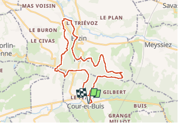
40 km | 51 km-effort
4h 49min
Yes
Trail Walking Primarette - Primarette - Photo
Walking
jacky.26sp

Walking

Easy
(2)
Primarette, Auvergne-Rhône-Alpes, Isère, France
12.8 km | 16.9 km-effort
3h 30min
Yes
Trail Walking Monsteroux-Milieu - Le Sanglier 2013 - Montsevenoux - Photo
Walking
tracegps

Walking

Medium
Monsteroux-Milieu, Auvergne-Rhône-Alpes, Isère, France
15.5 km | 20 km-effort
3h 30min
Yes
Trail On foot Meyssiez - Meyssiez - 10,7 km - 297 m de dénivelé - 3h30 - Photo
On foot
Clubléorando

On foot

Medium
Meyssiez, Auvergne-Rhône-Alpes, Isère, France
10.7 km | 14.7 km-effort
3h 30min
Yes
Trail On foot Eyzin-Pinet - Eyzin Pinet - château Pinet - 11 km - 298 m de dénivelé - 4h - Photo
On foot
Clubléorando

On foot

Medium
Eyzin-Pinet, Auvergne-Rhône-Alpes, Isère, France
11 km | 15 km-effort
4h 0min
Yes
Trail On foot Montseveroux - Montseveroux - la chèvrerie de la combe Bernard - 12,1 km - 222 m de dénivelé - 3h30 - Photo
On foot
Clubléorando

On foot

Medium
Montseveroux, Auvergne-Rhône-Alpes, Isère, France
12.1 km | 15 km-effort
3h 30min
Yes
Trail On foot Eyzin-Pinet - Eyzin Pinet - les Blaches - 8,6 km - 131 m de dénivelé - 3h - Photo
On foot
Clubléorando

On foot

Easy
Eyzin-Pinet, Auvergne-Rhône-Alpes, Isère, France
8.6 km | 10.3 km-effort
3h 0min
Yes
Trail On foot Eyzin-Pinet - Eyzin Pinet - château Pinet - 10,1 km - 184 m de dénivelé - 3h30 - Photo
On foot
Clubléorando

On foot

Easy
Eyzin-Pinet, Auvergne-Rhône-Alpes, Isère, France
10.1 km | 12.5 km-effort
3h 30min
Yes
Trail Walking Eyzin-Pinet - Eyzin Pinet - les Blaches - 10,8 km - 154 m de dénivelé - 3h30 - Photo
Walking
Clubléorando

Walking

Medium
Eyzin-Pinet, Auvergne-Rhône-Alpes, Isère, France
10.8 km | 12.8 km-effort
3h 30min
Yes


Close
My subscriptions