Trail On foot Eyzin-Pinet - Eyzin Pinet - château Pinet - 11 km - 298 m de dénivelé - 4h - Photo

Eyzin Pinet - château Pinet - 11 km - 298 m de dénivelé - 4h

© OpenStreetMap contributors
Length
Length
11 km
Max alt
Max alt
443 m
Uphill gradient
Uphill gradient
298 m
Km-Effort
Km-Effort  
15 km
Min alt
Min alt
266 m
Downhill gradient
Downhill gradient
298 m
Boucle
Boucle
Yes
Creation date :
2023-02-26 15:02:31.907
Updated on :
2023-02-26 15:10:14.359

(0 Reviews)

On foot
On foot
4h00
Difficulty : Medium

Scan this QR Code to open this trail in the SityTrail application

FREE GPS app for hiking

Logo SityTrail SityTrail

IGN / Geographical institutes

Download SityTrail from the App Store Download SityTrail from Google Play

Logo SityTrail SityTrail World

The world is yours!

Download SityTrail from the App Store Download SityTrail from Google Play Download SityTrail on Huawei AppGallery

About

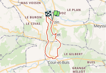
Trail On foot of 11 km to be discovered at Auvergne-Rhône-Alpes, Isère, Eyzin-Pinet. This trail is proposed by Clubléorando.

Description

Balade en boucle au départ du parking de la piscine du village d'Eyzin Pinet (rue des grillons). Prendre le chemin plein sud jusqu'au hameau Cola puis le entier à gauche qui mène à la maison David. Monter par le sentier à travers la forêt domaniale des Blaches puis traverser la D 538 et continuer le sentier jusqu'aux hameaux Fit et Portes. Retour par le sentier qui passe au hameau des Blaches puis redescendre au château Pinet. Prendre en conte bas un sentier sur la droite qui redescend au village d'Eyzin Pinet

Elevation profile

Positioning

Country:
France
Region :
Auvergne-Rhône-Alpes
Department/Province :
Isère
Municipality :
Eyzin-Pinet
Location:
Unknown
Start:(UTM)
656114 ; 5037614 (31T) N.

Trails nearby

Trail Mountain bike Monsteroux-Milieu - sanglier - Photo
Mountain bike
phusser

Mountain bike

Very easy
(1)
Monsteroux-Milieu, Auvergne-Rhône-Alpes, Isère, France
40 km | 51 km-effort
4h 49min
Yes
Trail Walking Cour-et-Buis - 38-Cour-et-Buis-Eyzin-restau-18km-420mdec22 - Photo
Walking
SyMA

Walking

Medium
(1)
Cour-et-Buis, Auvergne-Rhône-Alpes, Isère, France
20 km | 26 km-effort
5h 41min
Yes
Trail Walking Moidieu-Détourbe - 38 Moidieu Detourbe court 16km 300m - Photo
Walking
SyMA

Walking

Easy
Moidieu-Détourbe, Auvergne-Rhône-Alpes, Isère, France
16.1 km | 20 km-effort
4h 39min
Yes
Trail Walking Monsteroux-Milieu - Le Sanglier 2013 - Montsevenoux - Photo
Walking
tracegps

Walking

Medium
Monsteroux-Milieu, Auvergne-Rhône-Alpes, Isère, France
15.5 km | 20 km-effort
3h 30min
Yes
Trail On foot Meyssiez - Meyssiez - 10,7 km - 297 m de dénivelé - 3h30 - Photo
On foot
Clubléorando

On foot

Medium
Meyssiez, Auvergne-Rhône-Alpes, Isère, France
10.7 km | 14.7 km-effort
3h 30min
Yes
Trail On foot Eyzin-Pinet - Eyzin Pinet - les Blaches - 8,6 km - 131 m de dénivelé - 3h - Photo
On foot
Clubléorando

On foot

Easy
Eyzin-Pinet, Auvergne-Rhône-Alpes, Isère, France
8.6 km | 10.3 km-effort
3h 0min
Yes
Trail On foot Monsteroux-Milieu - Monsteroux Milieu - 11 km - 252 m de dénivelé  - 3h - Photo
On foot
Clubléorando

On foot

Medium
Monsteroux-Milieu, Auvergne-Rhône-Alpes, Isère, France
10.5 km | 13.9 km-effort
3h 0min
Yes
Trail On foot Eyzin-Pinet - Eyzin Pinet - château Pinet - 10,1 km - 184 m de dénivelé - 3h30 - Photo
On foot
Clubléorando

On foot

Easy
Eyzin-Pinet, Auvergne-Rhône-Alpes, Isère, France
10.1 km | 12.5 km-effort
3h 30min
Yes
Trail On foot Estrablin - Estrablin - les crêtes - 11 km - 229 m de dénivelé - 3h30 - Photo
On foot
Clubléorando

On foot

Easy
Estrablin, Auvergne-Rhône-Alpes, Isère, France
11 km | 14 km-effort
3h 30min
Yes


Close
My subscriptions