


Le chant des cailloux

latribuduchesnay
User
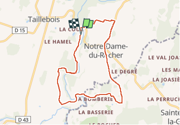

Length
8.1 km

Max alt
210 m

Uphill gradient
134 m
Km-Effort
9.9 km

Min alt
123 m

Downhill gradient
138 m
Boucle
Yes
Creation date :
2023-04-30 12:48:25.328
Updated on :
2023-04-30 18:02:53.115
2h00
Difficulty : Medium

FREE GPS app for hiking
 SityTrail
IGN / Geographical institutes
SityTrail Plus
The world is yours!
About
Trail Walking of 8.1 km to be discovered at Normandy, Orne, Athis-Val-de-Rouvre. This trail is proposed by latribuduchesnay.
Positioning
Country:
France
Region :
Normandy
Department/Province :
Orne
Municipality :
Athis-Val-de-Rouvre
Location:
Taillebois
Start:(Dec)
Start:(UTM)
689875 ; 5408277 (30U) N.
Comments