Trail Walking Beaulieu - [Itinéraire] D'un calvaire à l'autre - Photo

[Itinéraire] D'un calvaire à l'autre

 ODDAD78
ODDAD78

User

© OpenStreetMap contributors
Length
Length
5.7 km
Max alt
Max alt
227 m
Uphill gradient
Uphill gradient
43 m
Km-Effort
Km-Effort  
6.3 km
Min alt
Min alt
203 m
Downhill gradient
Downhill gradient
45 m
Boucle
Boucle
Yes
Creation date :
2023-07-03 07:54:54.033
Updated on :
2023-07-03 07:56:22.359

(0 Reviews)

Walking
Walking
1h25
Difficulty : Medium

Scan this QR Code to open this trail in the SityTrail application

FREE GPS app for hiking

Logo SityTrail SityTrail

IGN / Geographical institutes

Download SityTrail from the App Store Download SityTrail from Google Play

Logo SityTrail SityTrail World

The world is yours!

Download SityTrail from the App Store Download SityTrail from Google Play Download SityTrail on Huawei AppGallery

About

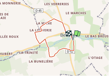
Trail Walking of 5.7 km to be discovered at Normandy, Orne, Beaulieu. This trail is proposed by ODDAD78.

Description

Ce circuit tranquille vous emmène en balade autour de Beaulieu et vous fais découvrir nombre de ses patrimoines.
Départ / Arrivée : Beaulieu
Prendre le chemin forestier qui longe l'arboretum jusqu'à l'entrée du château des Routis. Face à cette entrée, tourner à droite, puis, au bout de cette petite route, prendre à droite la D 45 sur 20m (route de Beaulieu à St-Maurice-les-Charençay).
Après le calvaire de la croix de fer, emprunter le chemin à gauche et le suivre jusqu'au haras "L'écurie du Choquel", au hameau du Haut-Poirier.
Puis, prendre à droite et continuer vers Pommerai (un ancien moulin est visible sur votre gauche). Poursuivre jusqu'à la D 258. Tourner à gauche et poursuivre sur 200m. Puis prendre à droite le chemin à travers champs. A l'orée du bois suivre à droite jusqu'au hameau La Louverie.
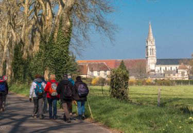
Prendre à gauche, passer devant La Mière. Rejoindre la D 45. Prendre à droite jusqu'au carrefour de la Croix Blanche et encore à droite pour rejoindre le bourg de Beaulieu. Passer devant l'église (se visite) pour rejoindre l'arboretum en passant par "Les Fossés du Roy" (panneau explicatif).

Source : https://rando-perche.fr/a-pied/dun-calvaire-a-lautre/

Elevation profile

Points of interest

Positioning

Country:
France
Region :
Normandy
Department/Province :
Orne
Municipality :
Beaulieu
Location:
Unknown
Start:(UTM)
334115 ; 5394099 (31U) N.

Trails nearby

Trail Walking Charencey - Saint-Maurice-lès-Charencey - Soligny-la-Trappe 25 km - Photo
Walking

Walking

Medium
Charencey, Normandy, Orne, France
24 km | 28 km-effort
6h 22min
No
Trail Walking Charencey - Saint-Maurice-les-Charencey - Tourouvre 28 km - Photo
Walking

Walking

Easy
Charencey, Normandy, Orne, France
26 km | 30 km-effort
6h 53min
No
Trail Walking Chennebrun - Circuit des Normands - Chennebrun - Photo
Walking
tracegps

Walking

Easy
Chennebrun, Normandy, Eure, France
5.5 km | 5.9 km-effort
1h 19min
Yes
Trail Walking Gournay-le-Guérin - Circuit des Fermes -  Gournay-le-Guérin  - Photo
Walking
tracegps

Walking

Easy
Gournay-le-Guérin, Normandy, Eure, France
7.3 km | 7.9 km-effort
1h 49min
Yes
Trail Walking Chennebrun - Circuit des Normands - Chennebrun  - Photo
Walking
tracegps

Walking

Easy
Chennebrun, Normandy, Eure, France
5.5 km | 5.9 km-effort
1h 19min
Yes
Trail Walking Beaulieu - [Itinéraire] Autour du bourg - Photo
Walking
ODDAD78

Walking

Easy
Beaulieu, Normandy, Orne, France
4.2 km | 4.6 km-effort
1h 2min
Yes
Trail Walking Saint-Christophe-sur-Avre - st Christophe - Photo
Walking
bipf

Walking

Very easy
Saint-Christophe-sur-Avre, Normandy, Eure, France
510 m | 556 m-effort
15min
No
Trail Walking Charencey - TPE 2018 Etape 3 Saint-Maurice-lès-Charencey - Tourouvre 26,1Km - Photo
Walking
ODDAD78

Walking

Medium
Charencey, Normandy, Orne, France
26 km | 31 km-effort
6h 43min
No
Trail Walking Beaulieu - Beaulieu  - Photo
Walking
ODDAD78

Walking

Medium
Beaulieu, Normandy, Orne, France
10.2 km | 11.3 km-effort
2h 58min
No


Close
My subscriptions