Trail Other activity Cholet - Cholet-Nantes - Photo
 st141230
st141230

User

© OpenStreetMap contributors
Length
Length
78 km
Max alt
Max alt
141 m
Uphill gradient
Uphill gradient
546 m
Km-Effort
Km-Effort  
86 km
Min alt
Min alt
0 m
Downhill gradient
Downhill gradient
659 m
Boucle
Boucle
No
Creation date :
2014-12-30 00:00:00.0
Updated on :
2014-12-30 00:00:00.0

(2 Reviews)

Other activity
Other activity
--
Difficulty : Unknown

Scan this QR Code to open this trail in the SityTrail application

FREE GPS app for hiking

Logo SityTrail SityTrail

IGN / Geographical institutes

Download SityTrail from the App Store Download SityTrail from Google Play

Logo SityTrail SityTrail World

The world is yours!

Download SityTrail from the App Store Download SityTrail from Google Play Download SityTrail on Huawei AppGallery

About

Trail Other activity of 78 km to be discovered at Pays de la Loire, Maine-et-Loire, Cholet. This trail is proposed by st141230.

Description

Tracé de l'ancienne ligne de chemin de fer à voie métrique du Petit Anjou (OV)

Elevation profile

Points of interest

Point of interest Nantes - Nantes Anjou (Gare) - Photo
st141230
Point of interest Nantes - Nantes PO (Gare) - Photo
st141230
Point of interest Saint-Sébastien-sur-Loire - St Sébastien sur Loire (Gare) - Photo
st141230
SAINT-SÉBASTIEN-SUR-LOIRE 
Point of interest Basse-Goulaine - Basse Goulaine (Gare) - Photo
st141230
BASSE-GOULAINE 
Point of interest Haute-Goulaine - Haute Goulaine (Gare) - Photo
st141230
HAUTE-GOULAINE 
Point of interest Saint-Julien-de-Concelles - Embreil (Gare) - Photo
st141230
SAINT-JULIEN-DE-CONCELLES 
Point of interest Saint-Julien-de-Concelles - La Queue des Haies (Halte) - Photo
st141230
SAINT-JULIEN-DE-CONCELLES 
Point of interest Saint-Julien-de-Concelles - St Julien de Concelles (Gare) - Photo
st141230
SAINT-JULIEN-DE-CONCELLES 
Point of interest Le Loroux-Bottereau - Landelle (Halte) - Photo
st141230
LE LOROUX-BOTTEREAU 
Point of interest Le Loroux-Bottereau - Le Loroux Bottereau (Gare) - Photo
st141230
LE LOROUX-BOTTEREAU 
Point of interest Le Loroux-Bottereau - Douet Rouaud (Halte) - Photo
st141230
LE LOROUX-BOTTEREAU 
Point of interest Le Loroux-Bottereau - La Remaudière (Gare) - Photo
st141230
LE LOROUX-BOTTEREAU 
Point of interest Orée-d'Anjou - La Boissière du Doré (Gare) - Photo
st141230
Point of interest Montrevault-sur-Èvre - St Christophe La Couperie (Halte) - Photo
st141230
MONTREVAULT-SUR-ÈVRE 
Point of interest Montrevault-sur-Èvre - Le Puiset Doré (Gare) - Photo
st141230
MONTREVAULT-SUR-ÈVRE 
Point of interest Montrevault-sur-Èvre - St Rémy en Mauges (Halte) - Photo
st141230
MONTREVAULT-SUR-ÈVRE 
Point of interest Montrevault-sur-Èvre - Montrevault (Gare) - Photo
st141230
MONTREVAULT-SUR-ÈVRE 
Point of interest Beaupréau-en-Mauges - Le Fief Sauvin (Halte) - Photo
st141230
BEAUPRÉAU-EN-MAUGES 
Point of interest Beaupréau-en-Mauges - Beaupréau (Gare) - Photo
st141230
BEAUPRÉAU-EN-MAUGES 
Point of interest Beaupréau-en-Mauges - Chapuseau (Halte) - Photo
st141230
BEAUPRÉAU-EN-MAUGES 
Point of interest Sèvremoine - St Macaire en Mauges (Gare) - Photo
st141230
Point of interest Bégrolles-en-Mauges - Begrolles en Mauges (Gare) - Photo
st141230
BÉGROLLES-EN-MAUGES 
Point of interest Saint-Léger-sous-Cholet - St Léger sous Cholet (Gare) - Photo
st141230
SAINT-LÉGER-SOUS-CHOLET 
Point of interest Cholet - Cholet (Gare) - Photo
st141230

Positioning

Country:
France
Region :
Pays de la Loire
Department/Province :
Maine-et-Loire
Municipality :
Cholet
Location:
Cholet
Start:(UTM)
661594 ; 5214878 (30T) N.

Comments

Please log in to post a review or rate the element


Trails nearby

Trail On foot Cholet - La Ribou'cle - Photo
On foot
PRO

On foot

Easy
Cholet, Pays de la Loire, Maine-et-Loire, France
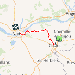
10.9 km | 12.4 km-effort
2h 48min
Yes
Trail Walking La Tessoualle - MAINE ET LOIRE: TOUR DU LAC DE RIBOU - Photo
Walking
djeepee74

Walking

Easy
La Tessoualle, Pays de la Loire, Maine-et-Loire, France
11.3 km | 12.8 km-effort
3h 30min
Yes
Trail Running Cholet - Autour de Cholet - Photo
Running
tracegps

Running

Medium
Cholet, Pays de la Loire, Maine-et-Loire, France
11.9 km | 13.5 km-effort
1h 15min
Yes
Trail Walking Cholet - Autour de Cholet - Photo
Walking
tracegps

Walking

Medium
Cholet, Pays de la Loire, Maine-et-Loire, France
11.9 km | 13.5 km-effort
2h 30min
Yes
Trail Cycle Mazières-en-Mauges - 2012-07-02 Mazieres - Étang des Noues - Peronne  - Photo
Cycle
cagouille79

Cycle

Easy
Mazières-en-Mauges, Pays de la Loire, Maine-et-Loire, France
28 km | 31 km-effort
3h 4min
Yes
Trail Mountain bike La Séguinière - La Séguinière 2022 - Photo
Mountain bike
pates_au_chaud

Mountain bike

Difficult
La Séguinière, Pays de la Loire, Maine-et-Loire, France
32 km | 36 km-effort
2h 51min
Yes
Trail Walking La Tessoualle - tour du lac de Ribou - Photo
Walking
lmrcho49

Walking

Very easy
(2)
La Tessoualle, Pays de la Loire, Maine-et-Loire, France
11.3 km | 12.7 km-effort
2h 54min
Yes
Trail Other activity Cholet - Ribou- les Noues - Photo
Other activity
Onillon

Other activity

Easy
Cholet, Pays de la Loire, Maine-et-Loire, France
10 km | 11.3 km-effort
2h 6min
Yes
Trail Mountain bike Cholet - Sans titre - Photo
Mountain bike
lmrcho49

Mountain bike

Easy
Cholet, Pays de la Loire, Maine-et-Loire, France
9.6 km | 10.9 km-effort
50min
Yes


Close
My subscriptions