


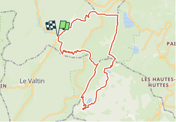
Plainfaing 19 350m +985m

DanielROLLET
User


7h40
Difficulty : Difficult

FREE GPS app for hiking
 SityTrail
IGN / Geographical institutes
SityTrail Plus
The world is yours!
About
Trail Walking of 19.3 km to be discovered at Grand Est, Vosges, Plainfaing. This trail is proposed by DanielROLLET.
Description
2023 10 10 - Avec Marie - 10h05 à 17h45
Départ/retour parking Etang des Dames
Beau temps
En arrivant au Lac Vert, nous avons préféré descendre sur la route
Pause 13h30 à 14h00 au Lac de Forlet (avec un vent trés froid!)
Belle balade
Partis un peu tard de Nancy...
Positioning
Comments