Trail Walking Signes - Vallon des Martyrs Signes - Photo

Vallon des Martyrs Signes

© OpenStreetMap contributors
Length
Length
14.9 km
Max alt
Max alt
561 m
Uphill gradient
Uphill gradient
251 m
Km-Effort
Km-Effort  
18.3 km
Min alt
Min alt
365 m
Downhill gradient
Downhill gradient
252 m
Boucle
Boucle
Yes
Creation date :
2024-01-31 08:47:50.066
Updated on :
2024-04-27 14:40:14.1

(0 Reviews)

Walking
Walking
4h09
Difficulty : Difficult

Scan this QR Code to open this trail in the SityTrail application

FREE GPS app for hiking

Logo SityTrail SityTrail

IGN / Geographical institutes

Download SityTrail from the App Store Download SityTrail from Google Play

Logo SityTrail SityTrail World

The world is yours!

Download SityTrail from the App Store Download SityTrail from Google Play Download SityTrail on Huawei AppGallery

About

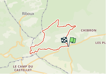
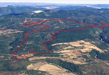
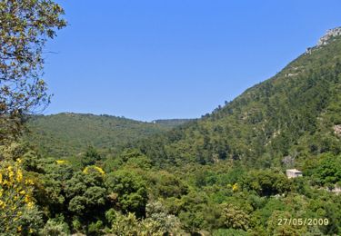
Trail Walking of 14.9 km to be discovered at Provence-Alpes-Côte d'Azur, Var, Signes. This trail is proposed by sonneville.

Description

Départ du rond point d2/d402 suivre la route de la carrière, monter jusqu'au Clos de Pégoun, chemin à gauche, le suivre jusqu'à une piste point 535, direction Crispin, le Mourven, Ch^steau Renard, piste vers 488, longer le champs de panneaux volta, contourner le vallon des martyrs et retour par vallon des Marseillais

Elevation profile

Photos

Positioning

Country:
France
Region :
Provence-Alpes-Côte d'Azur
Department/Province :
Var
Municipality :
Signes
Location:
Unknown
Start:(UTM)
727504 ; 4795178 (31T) N.

Trails nearby

Trail Walking Le Beausset - Trace_Quatre_Freres - Photo
Walking
GUIDE
affinetataille

Walking

Very difficult
(1)
Le Beausset, Provence-Alpes-Côte d'Azur, Var, France
14.8 km | 19.6 km-effort
4h 26min
Yes
Trail Walking Signes -  Chibron le Latay  - Photo
Walking
sonneville

Walking

Very easy
(1)
Signes, Provence-Alpes-Côte d'Azur, Var, France
14.2 km | 18.3 km-effort
5h 3min
Yes
Trail Walking Le Beausset - Tête du Cade par abime de Maramouyé - Photo
Walking
sonneville

Walking

Very easy
(1)
Le Beausset, Provence-Alpes-Côte d'Azur, Var, France
12.4 km | 16.1 km-effort
3h 36min
Yes
Trail Mountain bike Signes - De Chibron à Riboux et au Grand Vallon, sur le versant sud de la Sainte Baume - Photo
Mountain bike
tracegps

Mountain bike

Medium
(1)
Signes, Provence-Alpes-Côte d'Azur, Var, France
30 km | 39 km-effort
3h 0min
Yes
Trail Walking Signes - Signes - Vallon du Raby - Photo
Walking
tracegps

Walking

Medium
(2)
Signes, Provence-Alpes-Côte d'Azur, Var, France
8.3 km | 12.9 km-effort
2h 30min
Yes
Trail Walking Riboux - Riboux - Forêt de Malaucène - Photo
Walking
tracegps

Walking

Medium
(4)
Riboux, Provence-Alpes-Côte d'Azur, Var, France
12.2 km | 15.2 km-effort
2h 40min
Yes
Trail Walking Signes - grotte du mounoi signes - Photo
Walking
marchev

Walking

Medium
(1)
Signes, Provence-Alpes-Côte d'Azur, Var, France
17 km | 21 km-effort
4h 45min
Yes
Trail Mountain bike Signes - Le Mourré d'Agnis, itinéraire bis - Photo
Mountain bike
tracegps

Mountain bike

Very difficult
(1)
Signes, Provence-Alpes-Côte d'Azur, Var, France
43 km | 62 km-effort
5h 0min
Yes
Trail Walking Signes - Signes Col des Glacières Ste Baume - Photo
Walking
caminen

Walking

Very difficult
(1)
Signes, Provence-Alpes-Côte d'Azur, Var, France
16.4 km | 27 km-effort
6h 12min
Yes


Close
My subscriptions