Trail Walking Osséja - Bornes frontière en partant de la Fontaine Monnier  - Photo

Bornes frontière en partant de la Fontaine Monnier

© OpenStreetMap contributors
Length
Length
14.6 km
Max alt
Max alt
2207 m
Uphill gradient
Uphill gradient
816 m
Km-Effort
Km-Effort  
26 km
Min alt
Min alt
1511 m
Downhill gradient
Downhill gradient
839 m
Boucle
Boucle
Yes
Creation date :
2024-02-15 08:02:56.975
Updated on :
2024-02-15 14:23:35.628

(0 Reviews)

Walking
Walking
4h20
Difficulty : Very difficult

Scan this QR Code to open this trail in the SityTrail application

FREE GPS app for hiking

Logo SityTrail SityTrail

IGN / Geographical institutes

Download SityTrail from the App Store Download SityTrail from Google Play

Logo SityTrail SityTrail World

The world is yours!

Download SityTrail from the App Store Download SityTrail from Google Play Download SityTrail on Huawei AppGallery

About

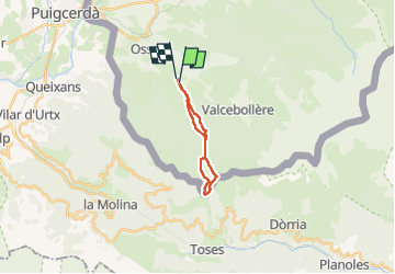
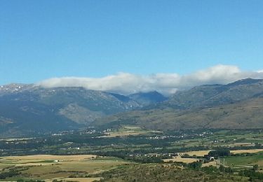
Trail Walking of 14.6 km to be discovered at Occitania, Pyrénées-Orientales, Osséja. This trail is proposed by rene091957.

Description

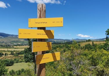
D'Osseja, à la Fontaine Monnier, prendre le chemin des Contrebandiers jusqu'au Col de Pradelles. Monter à la borne frontière 504, suivre la clôture vers l'Espagne, la borne 503 puis la borne 502 et remonter au Col de la Bassa.
Rejoindre le Col de Pradelles et descendre vers la fontaine Monnier.

Elevation profile

Positioning

Country:
France
Region :
Occitania
Department/Province :
Pyrénées-Orientales
Municipality :
Osséja
Location:
Unknown
Start:(UTM)
417654 ; 4694605 (31T) N.

Trails nearby

Trail Walking Nahuja - boucle de Nahuja - Photo
Walking
crijack

Walking

Medium
(1)
Nahuja, Occitania, Pyrénées-Orientales, France
11.8 km | 18.2 km-effort
2h 44min
Yes
Trail Walking Valcebollère - Chapelle San Bernabéu  - Photo
Walking
lolyhalle

Walking

Easy
Valcebollère, Occitania, Pyrénées-Orientales, France
5.4 km | 8.6 km-effort
1h 50min
No
Trail Walking Valcebollère - la cami de sant bertheleu - Photo
Walking
Merlos

Walking

Very easy
Valcebollère, Occitania, Pyrénées-Orientales, France
6.2 km | 9.7 km-effort
2h 25min
Yes
Trail Walking Valcebollère - Valcebollère chapelle Saint Barnabeu - Photo
Walking
crijack

Walking

Medium
Valcebollère, Occitania, Pyrénées-Orientales, France
11.3 km | 17.4 km-effort
3h 27min
Yes
Trail Walking Valcebollère - Valcebollère chapelle Saint Barnabeu - Photo
Walking
crijack

Walking

Medium
Valcebollère, Occitania, Pyrénées-Orientales, France
11.3 km | 17.4 km-effort
3h 27min
Yes
Trail Walking Err - d'Err à Bolquère - Photo
Walking
gberger

Walking

Easy
Err, Occitania, Pyrénées-Orientales, France
12.9 km | 18.5 km-effort
4h 10min
No
Trail Walking Sainte-Léocadie - la cerdagne se raconte - Photo
Walking
carapitouille

Walking

Easy
(1)
Sainte-Léocadie, Occitania, Pyrénées-Orientales, France
5.8 km | 7.5 km-effort
2h 4min
No
Trail Snowshoes Err - Pas de Lladres - Err - Photo
Snowshoes
tracegps

Snowshoes

Difficult
Err, Occitania, Pyrénées-Orientales, France
15.1 km | 28 km-effort
5h 0min
Yes
Trail Walking Nahuja - Nahuja refuge - Photo
Walking
marchev

Walking

Medium
Nahuja, Occitania, Pyrénées-Orientales, France
9.4 km | 14.8 km-effort
3h 54min
Yes


Close
My subscriptions