Trail Walking Sault - sault, saint trinit, aurel, sault - Photo

sault, saint trinit, aurel, sault

© OpenStreetMap contributors
Length
Length
17.1 km
Max alt
Max alt
863 m
Uphill gradient
Uphill gradient
266 m
Km-Effort
Km-Effort  
21 km
Min alt
Min alt
770 m
Downhill gradient
Downhill gradient
269 m
Boucle
Boucle
Yes
Creation date :
2024-04-07 07:52:56.784
Updated on :
2024-04-09 08:05:28.534

(0 Reviews)

Walking
Walking
6h45
Difficulty : Medium

Scan this QR Code to open this trail in the SityTrail application

FREE GPS app for hiking

Logo SityTrail SityTrail

IGN / Geographical institutes

Download SityTrail from the App Store Download SityTrail from Google Play

Logo SityTrail SityTrail World

The world is yours!

Download SityTrail from the App Store Download SityTrail from Google Play Download SityTrail on Huawei AppGallery

About

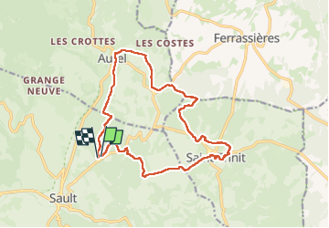
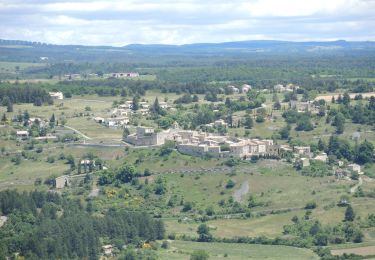
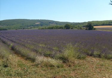
Trail Walking of 17.1 km to be discovered at Provence-Alpes-Côte d'Azur, Vaucluse, Sault. This trail is proposed by FLORENSAC.

Description

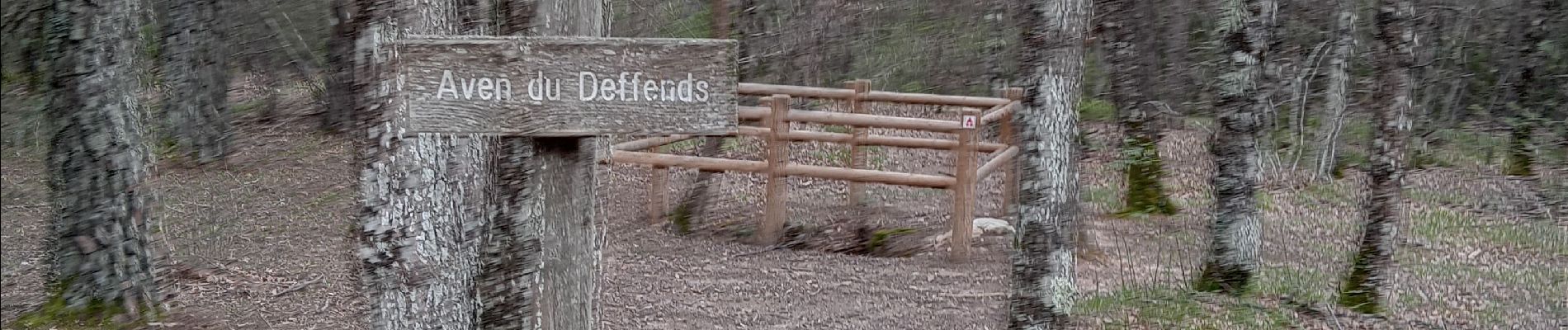
un peu longuet mais en sous bois ça passe

Elevation profile

Photos

Positioning

Country:
France
Region :
Provence-Alpes-Côte d'Azur
Department/Province :
Vaucluse
Municipality :
Sault
Location:
Unknown
Start:(UTM)
693928 ; 4886161 (31T) N.

Trails nearby

Trail Walking Sault - Sault - Le plateau d'Albion - Photo
Walking
Drailloun

Walking

Easy
(1)
Sault, Provence-Alpes-Côte d'Azur, Vaucluse, France
12.6 km | 16.5 km-effort
3h 25min
Yes
Trail On foot Sault - Le chemin des lavandes - Photo
On foot
PRO

On foot

Easy
Sault, Provence-Alpes-Côte d'Azur, Vaucluse, France
5 km | 6 km-effort
1h 21min
No
Trail Mountain bike Aurel - GTVAU-J4-Long - Photo
Mountain bike
PhilippeC54

Mountain bike

Very difficult
(1)
Aurel, Provence-Alpes-Côte d'Azur, Vaucluse, France
68 km | 89 km-effort
6h 9min
No
Trail Walking Aurel - PF-Aurel - Le Ventouret  - Photo
Walking
MicDul

Walking

Easy
Aurel, Provence-Alpes-Côte d'Azur, Vaucluse, France
12.3 km | 19.1 km-effort
3h 56min
Yes
Trail Walking Monieux - Moni eux 84 - Photo
Walking
jo-ba

Walking

Very easy
Monieux, Provence-Alpes-Côte d'Azur, Vaucluse, France
15.5 km | 20 km-effort
5h 40min
Yes
Trail Mountain bike Sault - Entre Sault et la Tour de Durefort - Photo
Mountain bike
tracegps

Mountain bike

Medium
Sault, Provence-Alpes-Côte d'Azur, Vaucluse, France
15.1 km | 20 km-effort
1h 30min
Yes
Trail Walking Sault - Entre Sault et la Tour de Durefort - Photo
Walking
tracegps

Walking

Medium
Sault, Provence-Alpes-Côte d'Azur, Vaucluse, France
15.1 km | 20 km-effort
4h 0min
Yes
Trail Cycle Sault - Circuit Vélo -  Le Plateau d'Albion - Sault - Photo
Cycle
tracegps

Cycle

Medium
Sault, Provence-Alpes-Côte d'Azur, Vaucluse, France
32 km | 39 km-effort
2h 30min
Yes
Trail Road bike Sault - Mombrun les thermes le Negron photos - Photo
Road bike
Daniel6952

Road bike

Very difficult
Sault, Provence-Alpes-Côte d'Azur, Vaucluse, France
68 km | 85 km-effort
4h 16min
Yes


Close
My subscriptions