Trail Walking Aachen - 2024-04-23_20h19m59_1189.gpx.xml - Photo

2024-04-23_20h19m59_1189.gpx.xml

© OpenStreetMap contributors
Length
Length
11.9 km
Max alt
Max alt
202 m
Uphill gradient
Uphill gradient
221 m
Km-Effort
Km-Effort  
14.9 km
Min alt
Min alt
126 m
Downhill gradient
Downhill gradient
222 m
Boucle
Boucle
Yes
Creation date :
2024-04-23 18:19:59.912
Updated on :
2024-04-23 18:23:41.718

(0 Reviews)

Walking
Walking
3h23
Difficulty : Medium

Scan this QR Code to open this trail in the SityTrail application

FREE GPS app for hiking

Logo SityTrail SityTrail

IGN / Geographical institutes

Download SityTrail from the App Store Download SityTrail from Google Play

Logo SityTrail SityTrail World

The world is yours!

Download SityTrail from the App Store Download SityTrail from Google Play Download SityTrail on Huawei AppGallery

About

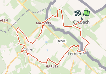
Trail Walking of 11.9 km to be discovered at North Rhine-Westphalia, Städteregion Aachen, Aachen. This trail is proposed by mumu.larandonneuse.

Description

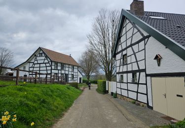
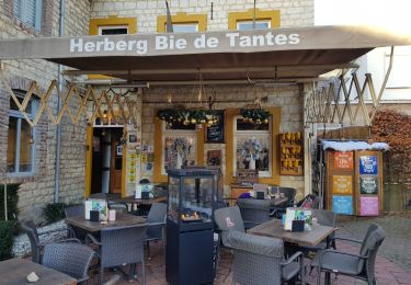
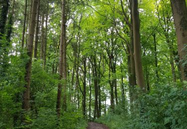
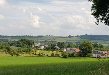
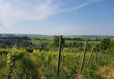
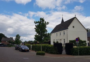
Juste au sud de Bocholtz se trouve la ville d'Orsbach, juste de l'autre côté de la frontière allemande. Au cours de cette balade vallonnée, transfrontalière et très panoramique vous descendrez jusqu'au hameau d'Oud-Lemiers et passerez devant le château de Genhoes avec une belle vue. Par des chemins de campagne, vous atteignez le hameau de Harles et par un beau sentier et à travers des prairies vous marchez jusqu'à Vijlen où vous pourrez faire une pause au restaurant Bergzicht. Le chemin du retour offre également de belles vues. Vous faites le tour de Vijlen avec une belle vue sur Melleschet puis descendez jusqu'au hameau de Mamelis. Vous montez jusqu'au Michaelshof isolé et revenez à Orsbach par un magnifique sentier panoramique.
ℹ️ www.wandelgidszuidlimburg.com n° 1189
🍺☕️🍰 Pause possible à Lemiers,  De Kornuiten van Koraal

Elevation profile

Positioning

Country:
Germany
Region :
North Rhine-Westphalia
Department/Province :
Städteregion Aachen
Municipality :
Aachen
Location:
Unknown
Start:(UTM)
711135 ; 5631730 (31U) N.

Trails nearby

Trail Walking Gulpen-Wittem - Mechelen  - Photo
Walking
GUIDE
mumu.larandonneuse

Walking

Medium
(1)
Gulpen-Wittem, Limburg, Unknown, Netherlands
14 km | 17.6 km-effort
3h 16min
Yes
Trail Walking Vaals - 2023-04-07_19h11m12_788 - Photo
Walking
GUIDE
mumu.larandonneuse

Walking

Medium
(1)
Vaals, Limburg, Unknown, Netherlands
12.9 km | 16.3 km-effort
3h 42min
Yes
Trail Walking Vaals - 2023-04-07_19h07m33_235 - Photo
Walking
GUIDE
mumu.larandonneuse

Walking

Medium
(1)
Vaals, Limburg, Unknown, Netherlands
14.7 km | 18.3 km-effort
4h 9min
Yes
Trail Walking Vaals - 2022-11-11_17h47m43_wandelroute---cittaslow-rondje-viele - Photo
Walking
GUIDE
mumu.larandonneuse

Walking

Medium
(1)
Vaals, Limburg, Unknown, Netherlands
12.8 km | 17.1 km-effort
3h 53min
Yes
Trail Walking Gulpen-Wittem - 2021-11-26_14h13m03_1450 (2) - Photo
Walking
GUIDE
mumu.larandonneuse

Walking

Easy
(1)
Gulpen-Wittem, Limburg, Unknown, Netherlands
10.6 km | 12.5 km-effort
2h 50min
Yes
Trail Walking Vaals - 2021-07-14_08h55m00_1431 - Photo
Walking
GUIDE
mumu.larandonneuse

Walking

Medium
(1)
Vaals, Limburg, Unknown, Netherlands
13.1 km | 16.6 km-effort
3h 46min
Yes
Trail Walking Gulpen-Wittem - 2021-07-01_13h51m24_077 - Photo
Walking
GUIDE
mumu.larandonneuse

Walking

Easy
(1)
Gulpen-Wittem, Limburg, Unknown, Netherlands
16.4 km | 20 km-effort
4h 35min
Yes
Trail Walking Gulpen-Wittem - 2021-06-14_21h05m37_853 - Photo
Walking
GUIDE
mumu.larandonneuse

Walking

Easy
(1)
Gulpen-Wittem, Limburg, Unknown, Netherlands
15.1 km | 19.3 km-effort
4h 23min
Yes
Trail On foot Gulpen-Wittem - Gulpen-Wittem Wi8 - Photo
On foot
PRO

On foot

Easy
Gulpen-Wittem, Limburg, Unknown, Netherlands
3.8 km | 4.6 km-effort
1h 3min
Yes


Close
My subscriptions