


2024 08 11 Bellême Foret

chlafaille
User
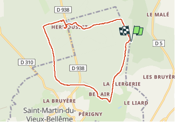

Length
8.3 km

Max alt
254 m

Uphill gradient
147 m
Km-Effort
10.3 km

Min alt
176 m

Downhill gradient
147 m
Boucle
Yes
Creation date :
2024-08-11 06:55:40.685
Updated on :
2024-08-11 16:10:58.937
1h50
Difficulty : Easy

FREE GPS app for hiking
 SityTrail
IGN / Geographical institutes
SityTrail Plus
The world is yours!
About
Trail Walking of 8.3 km to be discovered at Normandy, Orne, Belforêt-en-Perche. This trail is proposed by chlafaille.
Positioning
Country:
France
Region :
Normandy
Department/Province :
Orne
Municipality :
Belforêt-en-Perche
Location:
Sérigny
Start:(Dec)
Start:(UTM)
320359 ; 5363496 (31U) N.
Comments