Trail Walking Gémenos - les dents de roque forcade - Photo
 amiral13
amiral13

User GUIDE

© OpenStreetMap contributors
Length
Length
7.8 km
Max alt
Max alt
914 m
Uphill gradient
Uphill gradient
301 m
Km-Effort
Km-Effort  
11.8 km
Min alt
Min alt
723 m
Downhill gradient
Downhill gradient
300 m
Boucle
Boucle
Yes
Creation date :
2015-05-16 00:00:00.0
Updated on :
2015-05-16 00:00:00.0

(0 Reviews)

Walking
Walking
2h03
Difficulty : Medium

Scan this QR Code to open this trail in the SityTrail application

FREE GPS app for hiking

Logo SityTrail SityTrail

IGN / Geographical institutes

Download SityTrail from the App Store Download SityTrail from Google Play

Logo SityTrail SityTrail World

The world is yours!

Download SityTrail from the App Store Download SityTrail from Google Play Download SityTrail on Huawei AppGallery

About

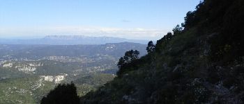
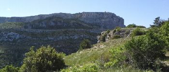
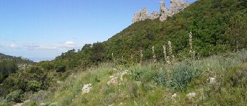
Trail Walking of 7.8 km to be discovered at Provence-Alpes-Côte d'Azur, Bouches-du-Rhône, Gémenos. This trail is proposed by amiral13.

Description

un beau parcours peu fréquenté, et agrémenté d'une rencontre inattendue, un chamois; ceux-ci ont été introduits il y a quelques années dans la partie est du massif et semblent s'être acclimatés.
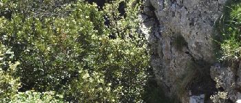
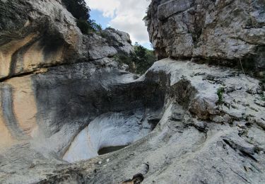
un passage nécessitera l'utilisation des mains pour un cours passage d'escalade facile. n'oubliez pas de faire une pose au niveau de l'aven dans lequel on peut descendre par quelques mètres d'escalade; prévoir une corde pour les moins aguerris.
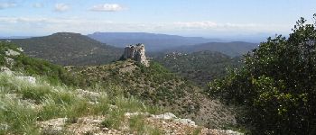
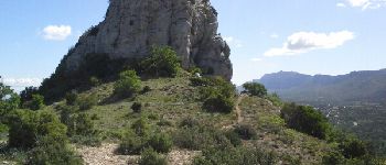
randonnée à déconseiller aux personnes sensibles au vide.

Elevation profile

Photos

Points of interest

Point of interest Gémenos - à l’approche des dents - Photo
amiral13
Point of interest Auriol - la sainte Victoire - Photo
amiral13
Point of interest Auriol - le passage clé - Photo
amiral13
Point of interest Auriol - Surplomb sur les dents - Photo
amiral13
Point of interest Gémenos - le pic de Bertagne - Photo
amiral13
Point of interest Gémenos - la sainte Baume - Photo
amiral13
GÉMENOS 
Point of interest Gémenos - la vallée de saint Pons - Photo
amiral13
Point of interest Plan-d'Aups-Sainte-Baume - un aven accessible - Photo
amiral13
PLAN-D'AUPS-SAINTE-BAUME 
Point of interest Plan-d'Aups-Sainte-Baume - La tour Cauvin - Photo
amiral13
PLAN-D'AUPS-SAINTE-BAUME 
Point of interest Auriol - la tour Cauvin - Photo
amiral13
Point of interest Plan-d'Aups-Sainte-Baume - vue sur le bau de Bertagne - Photo
amiral13
PLAN-D'AUPS-SAINTE-BAUME 
Point of interest Gémenos - le pic de bertagne - Photo
amiral13
Point of interest Gémenos - l'envers des dents - Photo
amiral13

Positioning

Country:
France
Region :
Provence-Alpes-Côte d'Azur
Department/Province :
Bouches-du-Rhône
Municipality :
Gémenos
Location:
Unknown
Start:(UTM)
715631 ; 4799388 (31T) N.

Trails nearby

Trail Walking Gémenos - St Pons Le Fauge Glacière  - Photo
Walking
GUIDE
lhomme.ph

Walking

Difficult
(1)
Gémenos, Provence-Alpes-Côte d'Azur, Bouches-du-Rhône, France
11.7 km | 18.6 km-effort
3h 56min
Yes
Trail Walking Gémenos - dent de roque forcade. cauvin.bertagne. 2 avril 2018 - Photo
Walking
marchev

Walking

Medium
(1)
Gémenos, Provence-Alpes-Côte d'Azur, Bouches-du-Rhône, France
12.7 km | 20 km-effort
4h 31min
Yes
Trail Walking Auriol - la crete des infernets - Photo
Walking
Coryphene

Walking

Difficult
(1)
Auriol, Provence-Alpes-Côte d'Azur, Bouches-du-Rhône, France
8.6 km | 14 km-effort
3h 22min
Yes
Trail Walking Gémenos - autour de Saint pons - Photo
Walking
Coryphene

Walking

Easy
(1)
Gémenos, Provence-Alpes-Côte d'Azur, Bouches-du-Rhône, France
11.6 km | 16.1 km-effort
3h 46min
Yes
Trail Walking Gémenos - Autour des Dents de Roque Forcade, Tour de Cauvin - Photo
Walking
tracegps

Walking

Difficult
(1)
Gémenos, Provence-Alpes-Côte d'Azur, Bouches-du-Rhône, France
7.6 km | 11.7 km-effort
3h 15min
Yes
Trail Mountain bike Gémenos - Gémenos - La Grande Baume - Photo
Mountain bike
tracegps

Mountain bike

Difficult
(1)
Gémenos, Provence-Alpes-Côte d'Azur, Bouches-du-Rhône, France
18.4 km | 29 km-effort
3h 30min
Yes
Trail Walking Plan-d'Aups-Sainte-Baume - La Grotte aux oiseaux - Plan d'Aups  - Photo
Walking
tracegps

Walking

Medium
(1)
Plan-d'Aups-Sainte-Baume, Provence-Alpes-Côte d'Azur, Var, France
8.8 km | 12.5 km-effort
2h 30min
Yes
Trail Walking Auriol - le ravin des Encanaux - Photo
Walking
GUIDE
amiral13

Walking

Difficult
Auriol, Provence-Alpes-Côte d'Azur, Bouches-du-Rhône, France
7.3 km | 12.2 km-effort
3h 10min
Yes
Trail Walking Plan-d'Aups-Sainte-Baume - Pic de Bertagne - Grotte Betton - Le plan d'aups - Photo
Walking
GUIDE
affinetataille

Walking

Medium
Plan-d'Aups-Sainte-Baume, Provence-Alpes-Côte d'Azur, Var, France
9.9 km | 15.7 km-effort
3h 30min
Yes


Close
My subscriptions