


J1 Guillestre Rue des Masques

Monjean
User
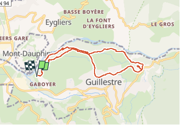

Length
8.9 km

Max alt
1141 m

Uphill gradient
348 m
Km-Effort
13.6 km

Min alt
908 m

Downhill gradient
346 m
Boucle
Yes
Creation date :
2024-11-05 16:34:00.066
Updated on :
2024-11-05 16:35:27.452
3h04
Difficulty : Difficult

FREE GPS app for hiking
 SityTrail
IGN / Geographical institutes
SityTrail Plus
The world is yours!
About
Trail Walking of 8.9 km to be discovered at Provence-Alpes-Côte d'Azur, Hautes-Alpes, Guillestre. This trail is proposed by Monjean.
Positioning
Country:
France
Region :
Provence-Alpes-Côte d'Azur
Department/Province :
Hautes-Alpes
Municipality :
Guillestre
Location:
Unknown
Start:(Dec)
Start:(UTM)
311863 ; 4948252 (32T) N.
Comments