


gilette ascros roquesteron pierrefeu gilette

franquen
User
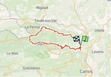

Length
69 km

Max alt
1155 m

Uphill gradient
1795 m
Km-Effort
93 km

Min alt
278 m

Downhill gradient
1798 m
Boucle
Yes
Creation date :
2025-05-01 09:11:55.716
Updated on :
2025-05-01 17:40:04.876
6h28
Difficulty : Very difficult

FREE GPS app for hiking
 SityTrail
IGN / Geographical institutes
SityTrail Plus
The world is yours!
About
Trail Mountain bike of 69 km to be discovered at Provence-Alpes-Côte d'Azur, Maritime Alps, Bonson. This trail is proposed by franquen.
Positioning
Country:
France
Region :
Provence-Alpes-Côte d'Azur
Department/Province :
Maritime Alps
Municipality :
Bonson
Location:
Unknown
Start:(Dec)
Start:(UTM)
352601 ; 4858725 (32T) N.
Comments