


Comus Montsegut

avdem
User
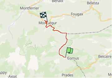

Length
15.5 km

Max alt
1131 m

Uphill gradient
639 m
Km-Effort
25 km

Min alt
608 m

Downhill gradient
839 m
Boucle
No
Creation date :
2025-05-15 06:52:03.264
Updated on :
2025-05-15 17:51:30.432
8h25
Difficulty : Easy

FREE GPS app for hiking
 SityTrail
IGN / Geographical institutes
SityTrail Plus
The world is yours!
About
Trail Walking of 15.5 km to be discovered at Occitania, Ariège, Prades. This trail is proposed by avdem.
Description
durdur
Photos


Positioning
Country:
France
Region :
Occitania
Department/Province :
Ariège
Municipality :
Prades
Location:
Unknown
Start:(Dec)
Start:(UTM)
407861 ; 4740846 (31T) N.
Comments