![](/images/other/stat-length.png)
![Trail Other activity Saint-Dié-des-Vosges - Grand Est - Ligne 18 - St Diè Schirmeck-la-Broque - Photo](https://media.geolcdn.com/t/1900/400/ext.pjpeg?maxdim=2&url=https%3A%2F%2Fservices.sitytrail.com%2FGeolivesWS%2FDownloadMedia.ashx%3FTrailID%3D451991%26Media%3Dc2463f84-4f3d-463c-be38-fbd2842dff00.jpg)
Grand Est - Ligne 18 - St Diè Schirmeck-la-Broque
mich54
User
![Length](/images/other/stat-length.png)
![Max alt](https://static1.geolcdn.com/siteimages/upload/files/1508320355ic_sort_altitude_max_24dp.png)
![Uphill gradient](https://static1.geolcdn.com/siteimages/upload/files/1508320355ic_sort_den_pos_24dp.png)
![Km-Effort](/images/other/stat-length.png)
![Min alt](https://static1.geolcdn.com/siteimages/upload/files/1508320355ic_sort_altitude_min_24dp.png)
![Downhill gradient](https://static1.geolcdn.com/siteimages/upload/files/1508320355ic_sort_den_neg_24dp.png)
![Boucle](https://static1.geolcdn.com/siteimages/upload/files/16400158638029165_repeat_loop_refresh_sync_direction_icon.png)
![Other activity](https://static1.geolcdn.com/sitytour/trail-icons/900.png)
5m
Difficulty : Unknown
![Scan this QR Code to open this trail in the SityTrail application](https://capi.geolives.com/qq0zvz2zws4bq2lad0pu/sitytour/trails/451991/qr.png?size=200)
FREE GPS app for hiking
About
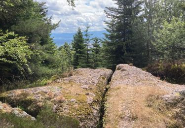
Trail Other activity of 45 km to be discovered at Grand Est, Vosges, Saint-Dié-des-Vosges. This trail is proposed by mich54.
Description
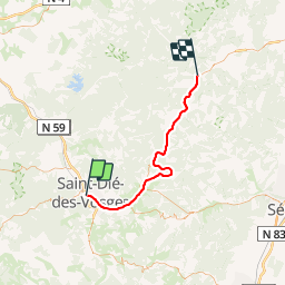
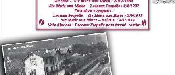
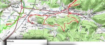
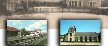
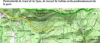
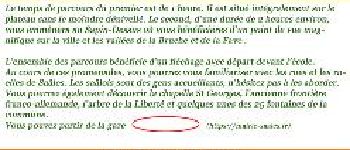
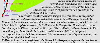
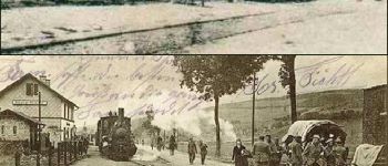
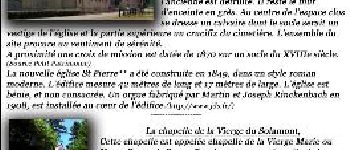
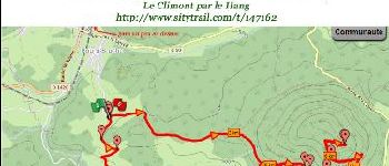
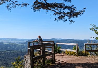
Ce n’est pas une randonnée pédestre que vous trouverez ci-joint, mais une randonnée ferroviaire, un petit voyage le long de la ligne 18, celle qui part de St-Diè dans les Vosges, traverse Saales, se poursuit dans cette belle région alsacienne et arrive à Schirmeck pour cette première partie. La seconde partie sera consacrée au parcours Schirmeck - Strasbourg.
Alors, installez-vous confortablement à bord d’un de nos TER, allumez votre tablette, connecter votre GPS et laisser vous guider et séduire par toutes les découvertes de nos belles régions.
Toutes les lignes ferroviaires de notre Région Grand-Est sont en cours de traitement.
(Concept protégé INPI)
(Toute remarque, erreur, modification sera la bienvenue et corrigée rapidement - letraindusoir54@gmail.com).
Points of interest
Positioning
Comments
Trails nearby
![Trail Mountain bike Saint-Dié-des-Vosges - vtt la voivre La Bure 29-03-19 - Photo](https://media.geolcdn.com/t/375/260/ext.jpg?maxdim=2&url=https%3A%2F%2Fmedia.geolcdn.com%2Ff%2F651ec868-e046-448c-a37f-e725fa61f50d.jpg)
![Mountain bike Mountain bike](https://static1.geolcdn.com/sitytour/trail-icons/202.png)
Mountain bike
![](/images/other/stat-length.png)
![](https://static1.geolcdn.com/siteimages/upload/files/16400158638029165_repeat_loop_refresh_sync_direction_icon.png)
![Trail Walking Saint-Michel-sur-Meurthe - massif de la madeleine - Photo](https://media.geolcdn.com/t/375/260/ext.jpg?maxdim=2&url=https%3A%2F%2Fservices.sitytrail.com%2FGeolivesWS%2FDownloadMedia.ashx%3FTrailID%3D1148232%26Media%3D20190421153638.jpg)
![Walking Walking](https://static1.geolcdn.com/sitytour/trail-icons/101.png)
Walking
![](/images/other/stat-length.png)
![](https://static1.geolcdn.com/siteimages/upload/files/16400158638029165_repeat_loop_refresh_sync_direction_icon.png)
![Trail On foot Taintrux - GR de Pays de Déodatie - Photo](https://media.geolcdn.com/t/375/260/ext.jpg?maxdim=2&url=https%3A%2F%2Fmedia.geolcdn.com%2Ff%2F8c9d86c2-6a8a-421f-b627-7552051e9313.jpeg)
![On foot On foot](https://static1.geolcdn.com/sitytour/trail-icons/100.png)
On foot
![](/images/other/stat-length.png)
![](https://static1.geolcdn.com/siteimages/upload/files/16400158638029165_repeat_loop_refresh_sync_direction_icon.png)
![Trail Walking Saint-Dié-des-Vosges - 2019-03-07 Marche Montée des Schlitteurs - Photo](https://media.geolcdn.com/t/375/260/ext.jpg?maxdim=2&url=https%3A%2F%2Fmedia.geolcdn.com%2Ff%2Fb6c7faad-e93b-4a65-8c3b-cd428aea5e79.jpg)
![Walking Walking](https://static1.geolcdn.com/sitytour/trail-icons/101.png)
Walking
![](/images/other/stat-length.png)
![](https://static1.geolcdn.com/siteimages/upload/files/16400158638029165_repeat_loop_refresh_sync_direction_icon.png)
![Trail Walking Taintrux - suuntoapp-Hiking-2024-05-10T08-54-36Z - Photo](https://media.geolcdn.com/t/375/260/ext.jpg?maxdim=2&url=https%3A%2F%2Fmedia.geolcdn.com%2Ff%2F9fe93acc-f8ea-40c3-b435-6f108f3a2d6d.jpg)
![Walking Walking](https://static1.geolcdn.com/sitytour/trail-icons/101.png)
Walking
![](/images/other/stat-length.png)
![](https://static1.geolcdn.com/siteimages/upload/files/16400158638029165_repeat_loop_refresh_sync_direction_icon.png)
![Trail Walking Saint-Dié-des-Vosges - Massif de l'Ormont et ses rochers remarquables - Photo](https://media.geolcdn.com/t/375/260/ext.jpg?maxdim=2&url=https%3A%2F%2Fmedia.geolcdn.com%2Ff%2F5bfc527b-060c-4d01-aae8-b360a5c8e4f1.jpg)
![Walking Walking](https://static1.geolcdn.com/sitytour/trail-icons/101.png)
Walking
![](/images/other/stat-length.png)
![](https://static1.geolcdn.com/siteimages/upload/files/16400158638029165_repeat_loop_refresh_sync_direction_icon.png)
![Trail Walking Saulcy-sur-Meurthe - Massif du KEMBERG - Photo](https://media.geolcdn.com/t/375/260/ext.jpg?maxdim=2&url=https%3A%2F%2Fmedia.geolcdn.com%2Ff%2Fa0e83b61-8364-418a-96af-6be211e18cd3.jpg)
![Walking Walking](https://static1.geolcdn.com/sitytour/trail-icons/101.png)
Walking
![](/images/other/stat-length.png)
![](https://static1.geolcdn.com/siteimages/upload/files/16400158638029165_repeat_loop_refresh_sync_direction_icon.png)
![Trail Walking Taintrux - Marche 09-07-22 18Km - Photo](https://media.geolcdn.com/t/375/260/ext.jpg?maxdim=2&url=https%3A%2F%2Fmedia.geolcdn.com%2Ff%2Fdffd94f9-cf6a-45ad-8857-0cc31d7aeb13.jpg)
![Walking Walking](https://static1.geolcdn.com/sitytour/trail-icons/101.png)
Walking
![](/images/other/stat-length.png)
![](https://static1.geolcdn.com/siteimages/upload/files/16400158638029165_repeat_loop_refresh_sync_direction_icon.png)
![Trail Walking Taintrux - Marche 06-06-22 24km - Photo](https://media.geolcdn.com/t/375/260/ext.jpg?maxdim=2&url=https%3A%2F%2Fmedia.geolcdn.com%2Ff%2F0cc2cfac-96ee-423b-8767-12701e4ef6de.jpg)
![Walking Walking](https://static1.geolcdn.com/sitytour/trail-icons/101.png)
Walking
![](/images/other/stat-length.png)
![](https://static1.geolcdn.com/siteimages/upload/files/16400158638029165_repeat_loop_refresh_sync_direction_icon.png)