Trail Mountain bike Reventin-Vaugris - VTT Reventin-La Balme - Photo
© OpenStreetMap contributors
Length
Length
26 km
Max alt
Max alt
409 m
Uphill gradient
Uphill gradient
524 m
Km-Effort
Km-Effort  
33 km
Min alt
Min alt
214 m
Downhill gradient
Downhill gradient
524 m
Boucle
Boucle
Yes
Creation date :
2016-06-25 00:00:00.0
Updated on :
2016-06-25 00:00:00.0

(0 Reviews)

Mountain bike
Mountain bike
2h13
Difficulty : Medium

Scan this QR Code to open this trail in the SityTrail application

FREE GPS app for hiking

Logo SityTrail SityTrail

IGN / Geographical institutes

Download SityTrail from the App Store Download SityTrail from Google Play

Logo SityTrail SityTrail World

The world is yours!

Download SityTrail from the App Store Download SityTrail from Google Play Download SityTrail on Huawei AppGallery

About

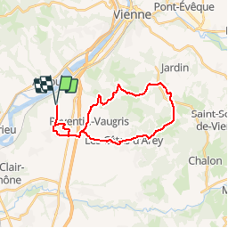
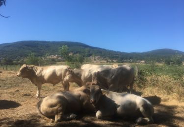
Trail Mountain bike of 26 km to be discovered at Auvergne-Rhône-Alpes, Isère, Reventin-Vaugris. This trail is proposed by Vicenzozo.

Description

Petite boucle avec un peu de route, points de vue sympa sur le parcours. Parcours en forêt avec quelques passages techniques tranquille.

Elevation profile

Positioning

Country:
France
Region :
Auvergne-Rhône-Alpes
Department/Province :
Isère
Municipality :
Reventin-Vaugris
Location:
Unknown
Start:(UTM)
641957 ; 5037450 (31T) N.

Trails nearby

Trail Walking Condrieu - ravin de l'arbuet - Photo
Walking
dan69390

Walking

Very easy
(1)
Condrieu, Auvergne-Rhône-Alpes, Rhône, France
7.2 km | 10 km-effort
2h 52min
Yes
Trail Mountain bike Les Côtes-d'Arey - Autour des Cotes d'Arey - Photo
Mountain bike
marc6262

Mountain bike

Difficult
(2)
Les Côtes-d'Arey, Auvergne-Rhône-Alpes, Isère, France
20 km | 26 km-effort
Unknown
Yes
Trail Walking Reventin-Vaugris - 38-reventin-10km-325m - Photo
Walking
SyMA

Walking

Easy
Reventin-Vaugris, Auvergne-Rhône-Alpes, Isère, France
10 km | 14.3 km-effort
3h 5min
Yes
Trail Hybrid bike Vienne - ViaRhona Vienne Coux 150km - Photo
Hybrid bike
GUIDE
thonyc

Hybrid bike

Medium
Vienne, Auvergne-Rhône-Alpes, Isère, France
146 km | 162 km-effort
Unknown
No
Trail Walking Vienne - 38-Vienne-visite-4.5km-mai21 - Photo
Walking
SyMA

Walking

Easy
Vienne, Auvergne-Rhône-Alpes, Isère, France
4.6 km | 5.2 km-effort
1h 47min
Yes
Trail Walking Vérin - 42-Vérin  Chuyer 18km 520m 18/5/20 - Photo
Walking
SyMA

Walking

Medium
Vérin, Auvergne-Rhône-Alpes, Loire, France
17.6 km | 25 km-effort
5h 12min
Yes
Trail Walking Reventin-Vaugris - REVENTIN 18 JC - Photo
Walking
Clubléorando

Walking

Very easy
(1)
Reventin-Vaugris, Auvergne-Rhône-Alpes, Isère, France
7.3 km | 10.5 km-effort
2h 12min
Yes
Trail Running Condrieu - Condrieu - Photo
Running
maelow

Running

Easy
Condrieu, Auvergne-Rhône-Alpes, Rhône, France
17.5 km | 23 km-effort
2h 23min
Yes
Trail Walking Reventin-Vaugris - REVENTIN VAUGRIS 2 JC - Photo
Walking
Clubléorando

Walking

Very easy
(1)
Reventin-Vaugris, Auvergne-Rhône-Alpes, Isère, France
12.9 km | 17.8 km-effort
3h 45min
Yes


Close
My subscriptions