Trail Other activity Échauffour - Haute Normandie - Ligne 400 - Echauffour - Bernay (Section de Echauffour à la limite Eure/Orne) 1 - Photo

Haute Normandie - Ligne 400 - Echauffour - Bernay (Section de Echauffour à la limite Eure/Orne) 1

 mich54
mich54

User

© OpenStreetMap contributors
Length
Length
18.7 km
Max alt
Max alt
324 m
Uphill gradient
Uphill gradient
119 m
Km-Effort
Km-Effort  
21 km
Min alt
Min alt
197 m
Downhill gradient
Downhill gradient
207 m
Boucle
Boucle
No
Creation date :
2016-12-24 00:00:00.0
Updated on :
2016-12-24 00:00:00.0

(0 Reviews)

Other activity
Other activity
5m
Difficulty : Unknown

Scan this QR Code to open this trail in the SityTrail application

FREE GPS app for hiking

Logo SityTrail SityTrail

IGN / Geographical institutes

Download SityTrail from the App Store Download SityTrail from Google Play

Logo SityTrail SityTrail Plus

The world is yours!

Download SityTrail from the App Store Download SityTrail from Google Play Download SityTrail on Huawei AppGallery

About

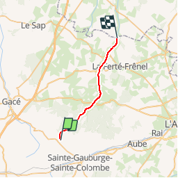
Trail Other activity of 18.7 km to be discovered at Normandy, Orne, Échauffour. This trail is proposed by mich54.

Description

La ligne d'Échauffour à Bernay est une ancienne ligne de chemin de fer française, se trouvant dans les départements de l'Orne et de l'Eure, et les régions Basse-Normandie et Haute-Normandie.
Elle fut ouverte le 22 décembre 1881.
Le 15 mai 1938, le service des voyageurs est supprimé.(Source Wikipédia)

Le tracé étant incertain de la limite Eure/Orne à La Trinité de Réville, j'ai donc séparé le tracé en 2 parties.

Elevation profile

Positioning

Country:
France
Region :
Normandy
Department/Province :
Orne
Municipality :
Échauffour
Location:
Unknown
Start:(UTM)
308375 ; 5402391 (31U) N.


Close
My subscriptions