Trail Other activity Alençon - Basse Normandie - Ligne 00F - Alençon - Domfront Partie 1 - Photo

Basse Normandie - Ligne 00F - Alençon - Domfront Partie 1

 mich54
mich54

User

© OpenStreetMap contributors
Length
Length
57 km
Max alt
Max alt
308 m
Uphill gradient
Uphill gradient
438 m
Km-Effort
Km-Effort  
62 km
Min alt
Min alt
118 m
Downhill gradient
Downhill gradient
418 m
Boucle
Boucle
No
Creation date :
2017-01-18 00:00:00.0
Updated on :
2017-01-18 00:00:00.0

(0 Reviews)

Other activity
Other activity
5m
Difficulty : Unknown

Scan this QR Code to open this trail in the SityTrail application

FREE GPS app for hiking

Logo SityTrail SityTrail

IGN / Geographical institutes

Download SityTrail from the App Store Download SityTrail from Google Play

Logo SityTrail SityTrail Plus

The world is yours!

Download SityTrail from the App Store Download SityTrail from Google Play Download SityTrail on Huawei AppGallery

About

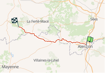
Trail Other activity of 57 km to be discovered at Normandy, Orne, Alençon. This trail is proposed by mich54.

Description

La ligne ferroviaire d'Alençon à Domfront est une ancienne ligne de chemin de fer française, qui traversait les départements de l'Orne et de la Mayenne.

Elle reliait entre elles les villes d'Alençon et de Domfront, mais également les villes d'Alençon et de Bagnoles-de-l'Orne ou La Ferté-Macé1.(Source Wikipédia)

Partie 1 de Alençon aux environs de Beaulandais.

Elevation profile

Positioning

Country:
France
Region :
Normandy
Department/Province :
Orne
Municipality :
Alençon
Location:
Unknown
Start:(UTM)
285437 ; 5368597 (31U) N.


Close
My subscriptions