


TCP 2

UDGI54
User
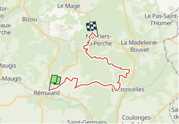

Length
23 km

Max alt
241 m

Uphill gradient
360 m
Km-Effort
28 km

Min alt
132 m

Downhill gradient
306 m
Boucle
No
Creation date :
2017-01-24 00:00:00.0
Updated on :
2017-01-24 00:00:00.0
--
Difficulty : Unknown

FREE GPS app for hiking
 SityTrail
IGN / Geographical institutes
SityTrail Plus
The world is yours!
About
Trail Walking of 23 km to be discovered at Normandy, Orne, Rémalard en Perche. This trail is proposed by UDGI54.
Positioning
Country:
France
Region :
Normandy
Department/Province :
Orne
Municipality :
Rémalard en Perche
Location:
Rémalard
Start:(Dec)
Start:(UTM)
335605 ; 5366436 (31U) N.
Comments