


StPierre Alb.-Roissarvaz- lac Carouge

Bogapuki
User
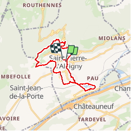

Length
13.2 km

Max alt
612 m

Uphill gradient
389 m
Km-Effort
18.4 km

Min alt
282 m

Downhill gradient
382 m
Boucle
Yes
Creation date :
2018-11-25 09:18:52.172
Updated on :
2018-11-25 09:18:52.172
3h53
Difficulty : Easy

FREE GPS app for hiking
 SityTrail
IGN / Geographical institutes
SityTrail Plus
The world is yours!
About
Trail Walking of 13.2 km to be discovered at Auvergne-Rhône-Alpes, Savoy, Saint-Pierre-d'Albigny. This trail is proposed by Bogapuki.
Description
13-01-2018
Rando facile, quoi qu'un peu longue. Magnifiques panoramas sur la vallée, le massif de la Lauzière, le Grand Arc...
Positioning
Country:
France
Region :
Auvergne-Rhône-Alpes
Department/Province :
Savoy
Municipality :
Saint-Pierre-d'Albigny
Location:
Unknown
Start:(Dec)
Start:(UTM)
277886 ; 5050114 (32T) N.
Comments