


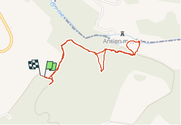
17# Le Val d'Orne

yannick-p
User

Length
2.3 km

Max alt
159 m

Uphill gradient
89 m
Km-Effort
3.5 km

Min alt
72 m

Downhill gradient
89 m
Boucle
Yes
Creation date :
2014-12-10 00:00:00.0
Updated on :
2014-12-10 00:00:00.0
38m
Difficulty : Medium

FREE GPS app for hiking
 SityTrail
IGN / Geographical institutes
SityTrail Plus
The world is yours!
About
Trail Walking of 2.3 km to be discovered at Normandy, Orne, Putanges-le-Lac. This trail is proposed by yannick-p.
Description
GC34Z75
Positioning
Country:
France
Region :
Normandy
Department/Province :
Orne
Municipality :
Putanges-le-Lac
Location:
La Forêt-Auvray
Start:(Dec)
Start:(UTM)
696332 ; 5409806 (30U) N.
Comments