![](/images/other/stat-length.png)
![Excursión Senderismo Najac - Vallée de L'Aveyron - Najac - Photo](https://media.geolcdn.com/t/1900/400/ext.pjpeg?maxdim=2&url=https%3A%2F%2Fservices.sitytrail.com%2FGeolivesWS%2FDownloadMedia.ashx%3FTrailID%3D129880%26Media%3D13449_2.jpg)
Vallée de L'Aveyron - Najac
tracegps
Usuario
![Longitud](/images/other/stat-length.png)
Longitud
11,5 km
![Altitud máxima](https://static1.geolcdn.com/siteimages/upload/files/1508320355ic_sort_altitude_max_24dp.png)
Altitud máxima
399 m
![Desnivel positivo](https://static1.geolcdn.com/siteimages/upload/files/1508320355ic_sort_den_pos_24dp.png)
Desnivel positivo
327 m
![Km-Effort](/images/other/stat-length.png)
Km-Effort
15,9 km
![Altitud mínima](https://static1.geolcdn.com/siteimages/upload/files/1508320355ic_sort_altitude_min_24dp.png)
Altitud mínima
187 m
![Desnivel negativo](https://static1.geolcdn.com/siteimages/upload/files/1508320355ic_sort_den_neg_24dp.png)
Desnivel negativo
324 m
![Boucle](https://static1.geolcdn.com/siteimages/upload/files/16400158638029165_repeat_loop_refresh_sync_direction_icon.png)
Boucle
Sí
Fecha de creación :
2014-12-10 00:00:00.0
Última modificación :
2014-12-10 00:00:00.0
![Senderismo](https://static1.geolcdn.com/sitytour/trail-icons/101.png)
2h30
Dificultad : Difícil
![Escanee este código QR para abrir la excursión en la aplicación SityTrail](https://capi.geolives.com/qq0zvz2zws4bq2lad0pu/sitytour/trails/129880/qr.png?size=200)
Aplicación GPS de excursión GRATIS
A propósito
Ruta Senderismo de 11,5 km a descubrir en Occitania, Aveyron, Najac. Esta ruta ha sido propuesta por tracegps.
Descripción
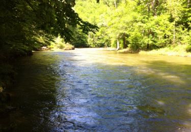
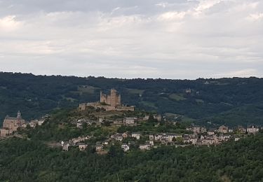
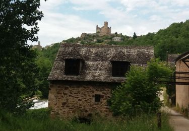
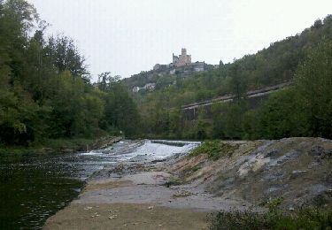
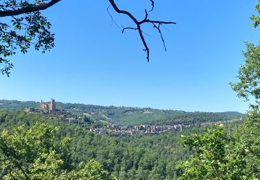
Départ de la salle des fêtes derrière la gendarmerie. Prendre vers le sud par le sentier où vous pouvez admirer le château de Najac.
Localización
País:
France
Región :
Occitania
Departamento/provincia :
Aveyron
Municipio :
Najac
Localidad:
Unknown
Salida:(Dec)
Salida:(UTM)
418945 ; 4896900 (31T) N.
Comentarios
Excursiones cerca
![Excursión Senderismo Najac - Boucle le long de l'Aveyron - Najac nord - Photo](https://media.geolcdn.com/t/375/260/ext.jpg?maxdim=2&url=https%3A%2F%2Fservices.sitytrail.com%2FGeolivesWS%2FDownloadMedia.ashx%3FTrailID%3D129870%26Media%3D13435_3.jpg)
![Senderismo Senderismo](https://static1.geolcdn.com/sitytour/trail-icons/101.png)
Boucle le long de l'Aveyron - Najac nord
Senderismo
Difícil
(1)
Najac,
Occitania,
Aveyron,
France
![](/images/other/stat-length.png)
8,3 km | 12,7 km-effort
2h 0min
![](https://static1.geolcdn.com/siteimages/upload/files/16400158638029165_repeat_loop_refresh_sync_direction_icon.png)
Sí
![Excursión Senderismo Najac - Autour de Najac par le village Vacances Bleues et Cassagnes - Photo](https://media.geolcdn.com/t/375/260/ext.jpg?maxdim=2&url=https%3A%2F%2Fmedia.geolcdn.com%2Ff%2Fb5d65376-d4d6-4c2d-b886-3cb9945240e5.jpg)
![Senderismo Senderismo](https://static1.geolcdn.com/sitytour/trail-icons/101.png)
Autour de Najac par le village Vacances Bleues et Cassagnes
Senderismo
Medio
Najac,
Occitania,
Aveyron,
France
![](/images/other/stat-length.png)
13,2 km | 17,8 km-effort
5h 4min
![](https://static1.geolcdn.com/siteimages/upload/files/16400158638029165_repeat_loop_refresh_sync_direction_icon.png)
Sí
![Excursión Senderismo Najac - boucle najac - Photo](https://media.geolcdn.com/t/375/260/ext.jpg?maxdim=2&url=https%3A%2F%2Fmedia.geolcdn.com%2Ff%2F093016b5-6c31-4391-b0bf-57b5bd4986d3.jpg)
![Senderismo Senderismo](https://static1.geolcdn.com/sitytour/trail-icons/101.png)
boucle najac
Senderismo
Muy fácil
Najac,
Occitania,
Aveyron,
France
![](/images/other/stat-length.png)
12,6 km | 0 m-effort
4h 11min
![](https://static1.geolcdn.com/siteimages/upload/files/16400158638029165_repeat_loop_refresh_sync_direction_icon.png)
Sí
![Excursión Bicicleta Najac - Circuit des 10 plus beaux villages de France de l'Aveyron - Najac - Capdenac - Photo](https://media.geolcdn.com/t/375/260/ext.jpg?maxdim=2&url=https%3A%2F%2Fservices.sitytrail.com%2FGeolivesWS%2FDownloadMedia.ashx%3FTrailID%3D172364%26Media%3D13704_5.jpg)
![Bicicleta Bicicleta](https://static1.geolcdn.com/sitytour/trail-icons/200.png)
Circuit des 10 plus beaux villages de France de l'Aveyron - Najac - Capdenac
Bicicleta
Difícil
Najac,
Occitania,
Aveyron,
France
![](/images/other/stat-length.png)
110 km | 136 km-effort
6h 0min
![](https://static1.geolcdn.com/siteimages/upload/files/16400158638029165_repeat_loop_refresh_sync_direction_icon.png)
No
![Excursión Senderismo Najac - Aveyron-121014 - Najac-Cassagnes (txt,gps,foto) - Photo](https://media.geolcdn.com/t/375/260/ext.jpg?maxdim=2&url=https%3A%2F%2Fservices.sitytrail.com%2FGeolivesWS%2FDownloadMedia.ashx%3FTrailID%3D160234%26Media%3D20121014140906.jpeg)
![Senderismo Senderismo](https://static1.geolcdn.com/sitytour/trail-icons/101.png)
Aveyron-121014 - Najac-Cassagnes (txt,gps,foto)
Senderismo
Muy fácil
Najac,
Occitania,
Aveyron,
France
![](/images/other/stat-length.png)
14,3 km | 19 km-effort
5h 30min
![](https://static1.geolcdn.com/siteimages/upload/files/16400158638029165_repeat_loop_refresh_sync_direction_icon.png)
Sí
![Excursión Senderismo Najac - Najac - Photo](https://media.geolcdn.com/t/375/260/ext.jpg?maxdim=2&url=https%3A%2F%2Fmedia.geolcdn.com%2Ff%2F85f071d6-8b47-495e-8981-89e627e43791.jpg)
![Senderismo Senderismo](https://static1.geolcdn.com/sitytour/trail-icons/101.png)
![Excursión Senderismo Najac - Du vvf à l’Aveyron - Photo](https://media.geolcdn.com/t/375/260/ext.jpg?maxdim=2&url=https%3A%2F%2Fmedia.geolcdn.com%2Ff%2F6f47dcda-60b9-41c8-8d33-f8a2b24d2ef2.jpg)
![Senderismo Senderismo](https://static1.geolcdn.com/sitytour/trail-icons/101.png)
Du vvf à l’Aveyron
Senderismo
Difícil
Najac,
Occitania,
Aveyron,
France
![](/images/other/stat-length.png)
6,8 km | 10 km-effort
2h 13min
![](https://static1.geolcdn.com/siteimages/upload/files/16400158638029165_repeat_loop_refresh_sync_direction_icon.png)
Sí
![Excursión Senderismo Najac - najac - Photo](https://media.geolcdn.com/t/375/260/ext.jpg?maxdim=2&url=https%3A%2F%2Fservices.sitytrail.com%2FGeolivesWS%2FDownloadMedia.ashx%3FTrailID%3D1010857%26Media%3Dfix__20180725161538.jpg)
![Senderismo Senderismo](https://static1.geolcdn.com/sitytour/trail-icons/101.png)
![Excursión Senderismo Najac - najac - Photo](https://media.geolcdn.com/t/375/260/ext.jpg?maxdim=2&url=https%3A%2F%2Fservices.sitytrail.com%2FGeolivesWS%2FDownloadMedia.ashx%3FTrailID%3D1010664%26Media%3Dfix__20180725161538.jpg)
![Senderismo Senderismo](https://static1.geolcdn.com/sitytour/trail-icons/101.png)
Fait avec Bene 15/08/15