![](/images/other/stat-length.png)
![Excursión Bici de montaña Cures - Lavardin / La Chapelle. - Photo](https://media.geolcdn.com/t/1900/400/ext.pjpeg?maxdim=2&url=https%3A%2F%2Fstatic1.geolcdn.com%2Fsiteimages%2Fupload%2Ffiles%2F1524743154velo.jpg)
Lavardin / La Chapelle.
xst
Usuario
![Longitud](/images/other/stat-length.png)
Longitud
32 km
![Altitud máxima](https://static1.geolcdn.com/siteimages/upload/files/1508320355ic_sort_altitude_max_24dp.png)
Altitud máxima
180 m
![Desnivel positivo](https://static1.geolcdn.com/siteimages/upload/files/1508320355ic_sort_den_pos_24dp.png)
Desnivel positivo
529 m
![Km-Effort](/images/other/stat-length.png)
Km-Effort
39 km
![Altitud mínima](https://static1.geolcdn.com/siteimages/upload/files/1508320355ic_sort_altitude_min_24dp.png)
Altitud mínima
77 m
![Desnivel negativo](https://static1.geolcdn.com/siteimages/upload/files/1508320355ic_sort_den_neg_24dp.png)
Desnivel negativo
533 m
![Boucle](https://static1.geolcdn.com/siteimages/upload/files/16400158638029165_repeat_loop_refresh_sync_direction_icon.png)
Boucle
Sí
Fecha de creación :
2020-09-12 15:18:49.259
Última modificación :
2020-09-12 17:54:16.614
![Bici de montaña](https://static1.geolcdn.com/sitytour/trail-icons/202.png)
2h27
Dificultad : Medio
![Escanee este código QR para abrir la excursión en la aplicación SityTrail](https://capi.geolives.com/qq0zvz2zws4bq2lad0pu/sitytour/trails/2548461/qr.png?size=200)
Aplicación GPS de excursión GRATIS
A propósito
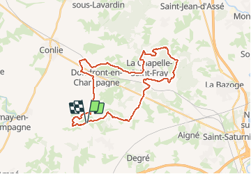
Ruta Bici de montaña de 32 km a descubrir en Países del Loira, Sarthe, Cures. Esta ruta ha sido propuesta por xst.
Descripción
chemins et petites routes. forêt et plaine. on voit très bien que le nord Sarthe est vallonné.
Localización
País:
France
Región :
Países del Loira
Departamento/provincia :
Sarthe
Municipio :
Cures
Localidad:
Unknown
Salida:(Dec)
Salida:(UTM)
277951 ; 5328791 (31U) N.
Comentarios
Excursiones cerca
![Excursión Bici de montaña Cures - rando nord-ouest - Photo](https://media.geolcdn.com/t/375/260/ext.jpg?maxdim=2&url=https%3A%2F%2Fstatic1.geolcdn.com%2Fsiteimages%2Fupload%2Ffiles%2F1524743154velo.jpg)
![Bici de montaña Bici de montaña](https://static1.geolcdn.com/sitytour/trail-icons/202.png)
rando nord-ouest
Bici de montaña
Muy difícil
Cures,
Países del Loira,
Sarthe,
France
![](/images/other/stat-length.png)
43 km | 52 km-effort
3h 37min
![](https://static1.geolcdn.com/siteimages/upload/files/16400158638029165_repeat_loop_refresh_sync_direction_icon.png)
Sí
![Excursión Bici de montaña Cures - rando journée en famille. - Photo](https://media.geolcdn.com/t/375/260/ext.jpg?maxdim=2&url=https%3A%2F%2Fstatic1.geolcdn.com%2Fsiteimages%2Fupload%2Ffiles%2F1524743154velo.jpg)
![Bici de montaña Bici de montaña](https://static1.geolcdn.com/sitytour/trail-icons/202.png)
rando journée en famille.
Bici de montaña
Medio
Cures,
Países del Loira,
Sarthe,
France
![](/images/other/stat-length.png)
46 km | 54 km-effort
4h 2min
![](https://static1.geolcdn.com/siteimages/upload/files/16400158638029165_repeat_loop_refresh_sync_direction_icon.png)
Sí
![Excursión Senderismo Cures - la Quinte nord ouest - Photo](https://media.geolcdn.com/t/375/260/ext.jpg?maxdim=2&url=https%3A%2F%2Fstatic1.geolcdn.com%2Fsiteimages%2Fupload%2Ffiles%2F1553511878bg_sport_marche.png)
![Senderismo Senderismo](https://static1.geolcdn.com/sitytour/trail-icons/101.png)
la Quinte nord ouest
Senderismo
Muy fácil
Cures,
Países del Loira,
Sarthe,
France
![](/images/other/stat-length.png)
9,1 km | 10,7 km-effort
1h 45min
![](https://static1.geolcdn.com/siteimages/upload/files/16400158638029165_repeat_loop_refresh_sync_direction_icon.png)
Sí
![Excursión Paseo ecuestre La Chapelle-Saint-Fray - la chapelle/la bazoge - Photo](https://media.geolcdn.com/t/375/260/ext.jpg?maxdim=2&url=https%3A%2F%2Fstatic1.geolcdn.com%2Fsiteimages%2Fupload%2Ffiles%2F1524743154cheval.jpg)
![Paseo ecuestre Paseo ecuestre](https://static1.geolcdn.com/sitytour/trail-icons/301.png)
la chapelle/la bazoge
Paseo ecuestre
Medio
(1)
La Chapelle-Saint-Fray,
Países del Loira,
Sarthe,
France
![](/images/other/stat-length.png)
20 km | 25 km-effort
3h 9min
![](https://static1.geolcdn.com/siteimages/upload/files/16400158638029165_repeat_loop_refresh_sync_direction_icon.png)
Sí
![Excursión Bici de montaña Cures - chemins et petites routes entre Cures, Lavardin et Neuvy. - Photo](https://media.geolcdn.com/t/375/260/ext.jpg?maxdim=2&url=https%3A%2F%2Fstatic1.geolcdn.com%2Fsiteimages%2Fupload%2Ffiles%2F1524743154velo.jpg)
![Bici de montaña Bici de montaña](https://static1.geolcdn.com/sitytour/trail-icons/202.png)
chemins et petites routes entre Cures, Lavardin et Neuvy.
Bici de montaña
Fácil
Cures,
Países del Loira,
Sarthe,
France
![](/images/other/stat-length.png)
22 km | 26 km-effort
1h 48min
![](https://static1.geolcdn.com/siteimages/upload/files/16400158638029165_repeat_loop_refresh_sync_direction_icon.png)
No
![Excursión Senderismo Cures - entre chemins et petites routes - Photo](https://media.geolcdn.com/t/375/260/ext.jpg?maxdim=2&url=https%3A%2F%2Fstatic1.geolcdn.com%2Fsiteimages%2Fupload%2Ffiles%2F1553511878bg_sport_marche.png)
![Senderismo Senderismo](https://static1.geolcdn.com/sitytour/trail-icons/101.png)
entre chemins et petites routes
Senderismo
Muy fácil
Cures,
Países del Loira,
Sarthe,
France
![](/images/other/stat-length.png)
4,9 km | 5,9 km-effort
58min
![](https://static1.geolcdn.com/siteimages/upload/files/16400158638029165_repeat_loop_refresh_sync_direction_icon.png)
Sí
![Excursión Enganche Cures - Cures attelage - Photo](https://media.geolcdn.com/t/375/260/ext.jpg?maxdim=2&url=https%3A%2F%2Fstatic1.geolcdn.com%2Fsiteimages%2Fupload%2Ffiles%2F1524743154cheval.jpg)
![Enganche Enganche](https://static1.geolcdn.com/sitytour/trail-icons/302.png)
Cures attelage
Enganche
Muy fácil
Cures,
Países del Loira,
Sarthe,
France
![](/images/other/stat-length.png)
18,5 km | 21 km-effort
2h 35min
![](https://static1.geolcdn.com/siteimages/upload/files/16400158638029165_repeat_loop_refresh_sync_direction_icon.png)
Sí
![Excursión Marcha nórdica Cures - FR Curés Solo 27-05-2021 - Photo](https://media.geolcdn.com/t/375/260/ext.jpg?maxdim=2&url=https%3A%2F%2Fstatic1.geolcdn.com%2Fsiteimages%2Fupload%2Ffiles%2F1545311037marcheuse_200dpi.jpg)
![Marcha nórdica Marcha nórdica](https://static1.geolcdn.com/sitytour/trail-icons/102.png)
FR Curés Solo 27-05-2021
Marcha nórdica
Muy fácil
Cures,
Países del Loira,
Sarthe,
France
![](/images/other/stat-length.png)
13,5 km | 15,7 km-effort
4h 43min
![](https://static1.geolcdn.com/siteimages/upload/files/16400158638029165_repeat_loop_refresh_sync_direction_icon.png)
Sí
![Excursión Marcha nórdica Cures - Fr Cures 27-05-2021 10 Km - Photo](https://media.geolcdn.com/t/375/260/ext.jpg?maxdim=2&url=https%3A%2F%2Fstatic1.geolcdn.com%2Fsiteimages%2Fupload%2Ffiles%2F1545311037marcheuse_200dpi.jpg)
![Marcha nórdica Marcha nórdica](https://static1.geolcdn.com/sitytour/trail-icons/102.png)
Fr Cures 27-05-2021 10 Km
Marcha nórdica
Muy fácil
Cures,
Países del Loira,
Sarthe,
France
![](/images/other/stat-length.png)
10,9 km | 12,3 km-effort
Desconocido
![](https://static1.geolcdn.com/siteimages/upload/files/16400158638029165_repeat_loop_refresh_sync_direction_icon.png)
Sí