![](/images/other/stat-length.png)
![Excursión Senderismo Roscanvel - boucle pointe espagnole - Photo](https://media.geolcdn.com/t/1900/400/ext.pjpeg?maxdim=2&url=https%3A%2F%2Fmedia.geolcdn.com%2Ff%2Ff95b8bb0-b672-48a5-a561-b1a849326fcc.jpg)
boucle pointe espagnole
fab0202
Usuario
![Longitud](/images/other/stat-length.png)
Longitud
13,7 km
![Altitud máxima](https://static1.geolcdn.com/siteimages/upload/files/1508320355ic_sort_altitude_max_24dp.png)
Altitud máxima
76 m
![Desnivel positivo](https://static1.geolcdn.com/siteimages/upload/files/1508320355ic_sort_den_pos_24dp.png)
Desnivel positivo
239 m
![Km-Effort](/images/other/stat-length.png)
Km-Effort
16,9 km
![Altitud mínima](https://static1.geolcdn.com/siteimages/upload/files/1508320355ic_sort_altitude_min_24dp.png)
Altitud mínima
15 m
![Desnivel negativo](https://static1.geolcdn.com/siteimages/upload/files/1508320355ic_sort_den_neg_24dp.png)
Desnivel negativo
238 m
![Boucle](https://static1.geolcdn.com/siteimages/upload/files/16400158638029165_repeat_loop_refresh_sync_direction_icon.png)
Boucle
Sí
Fecha de creación :
2020-10-21 08:25:19.715
Última modificación :
2020-10-21 12:43:25.928
![Senderismo](https://static1.geolcdn.com/sitytour/trail-icons/101.png)
3h19
Dificultad : Fácil
![Escanee este código QR para abrir la excursión en la aplicación SityTrail](https://capi.geolives.com/qq0zvz2zws4bq2lad0pu/sitytour/trails/2583583/qr.png?size=200)
Aplicación GPS de excursión GRATIS
A propósito
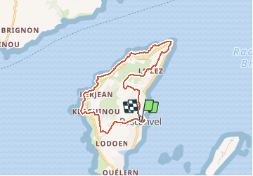
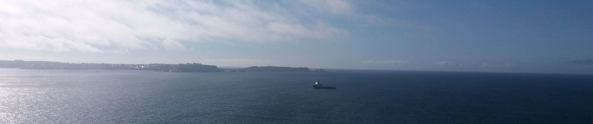
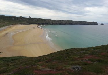
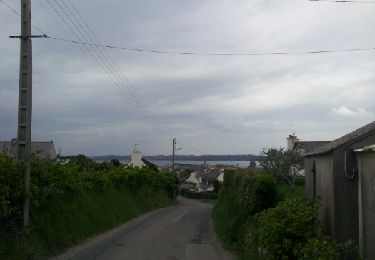
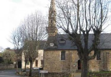
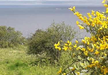
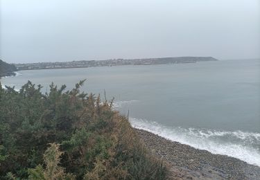
Ruta Senderismo de 13,7 km a descubrir en Bretaña, Finisterre, Roscanvel. Esta ruta ha sido propuesta por fab0202.
Descripción
belle rando avec une partie sur le sentier côtier et ses forts et une autre partie avec ses maisons typiques et lavoir.
Localización
País:
France
Región :
Bretaña
Departamento/provincia :
Finisterre
Municipio :
Roscanvel
Localidad:
Unknown
Salida:(Dec)
Salida:(UTM)
385194 ; 5352494 (30U) N.
Comentarios
Excursiones cerca
![Excursión Senderismo Camaret-sur-Mer - Autour de Camaret sur Mer - Photo](https://media.geolcdn.com/t/375/260/ext.jpg?maxdim=2&url=https%3A%2F%2Fmedia.geolcdn.com%2Ff%2Faeb5e75f-565d-4c3f-bdae-1cd067ca386f.jpg)
![Senderismo Senderismo](https://static1.geolcdn.com/sitytour/trail-icons/101.png)
Autour de Camaret sur Mer
Senderismo
Fácil
(1)
Camaret-sur-Mer,
Bretaña,
Finisterre,
France
![](/images/other/stat-length.png)
9,7 km | 0 m-effort
4h 2min
![](https://static1.geolcdn.com/siteimages/upload/files/16400158638029165_repeat_loop_refresh_sync_direction_icon.png)
Sí
![Excursión Senderismo Camaret-sur-Mer - a les 3 pointes de camaret - Photo](https://media.geolcdn.com/t/375/260/ext.jpg?maxdim=2&url=https%3A%2F%2Fservices.sitytrail.com%2FGeolivesWS%2FDownloadMedia.ashx%3FTrailID%3D268935%26Media%3Dfix__20140421164842.jpg)
![Senderismo Senderismo](https://static1.geolcdn.com/sitytour/trail-icons/101.png)
a les 3 pointes de camaret
Senderismo
Fácil
(1)
Camaret-sur-Mer,
Bretaña,
Finisterre,
France
![](/images/other/stat-length.png)
10,9 km | 14 km-effort
2h 58min
![](https://static1.geolcdn.com/siteimages/upload/files/16400158638029165_repeat_loop_refresh_sync_direction_icon.png)
Sí
![Excursión Senderismo Roscanvel - De Roscanvel à la Pointe des Espagnols - Photo](https://media.geolcdn.com/t/375/260/ext.jpg?maxdim=2&url=https%3A%2F%2Fservices.sitytrail.com%2FGeolivesWS%2FDownloadMedia.ashx%3FTrailID%3D109167%26Media%3D3210_1.jpg)
![Senderismo Senderismo](https://static1.geolcdn.com/sitytour/trail-icons/101.png)
De Roscanvel à la Pointe des Espagnols
Senderismo
Medio
(2)
Roscanvel,
Bretaña,
Finisterre,
France
![](/images/other/stat-length.png)
17,7 km | 22 km-effort
2h 30min
![](https://static1.geolcdn.com/siteimages/upload/files/16400158638029165_repeat_loop_refresh_sync_direction_icon.png)
Sí
![Excursión Senderismo Camaret-sur-Mer - tour de camaret - Photo](https://media.geolcdn.com/t/375/260/ext.jpg?maxdim=2&url=https%3A%2F%2Fstatic1.geolcdn.com%2Fsiteimages%2Fupload%2Ffiles%2F1553511878bg_sport_marche.png)
![Senderismo Senderismo](https://static1.geolcdn.com/sitytour/trail-icons/101.png)
tour de camaret
Senderismo
Fácil
(1)
Camaret-sur-Mer,
Bretaña,
Finisterre,
France
![](/images/other/stat-length.png)
18,4 km | 24 km-effort
4h 16min
![](https://static1.geolcdn.com/siteimages/upload/files/16400158638029165_repeat_loop_refresh_sync_direction_icon.png)
Sí
![Excursión Senderismo Roscanvel - Pointe des Espagnols - Roscanvel - Photo](https://media.geolcdn.com/t/375/260/ext.jpg?maxdim=2&url=https%3A%2F%2Fstatic1.geolcdn.com%2Fsiteimages%2Fupload%2Ffiles%2F1553511878bg_sport_marche.png)
![Senderismo Senderismo](https://static1.geolcdn.com/sitytour/trail-icons/101.png)
Pointe des Espagnols - Roscanvel
Senderismo
Medio
(2)
Roscanvel,
Bretaña,
Finisterre,
France
![](/images/other/stat-length.png)
14,9 km | 18,6 km-effort
3h 19min
![](https://static1.geolcdn.com/siteimages/upload/files/16400158638029165_repeat_loop_refresh_sync_direction_icon.png)
Sí
![Excursión Senderismo Roscanvel - pointe des espagnoles croson - Photo](https://media.geolcdn.com/t/375/260/ext.jpg?maxdim=2&url=https%3A%2F%2Fmedia.geolcdn.com%2Ff%2Fa45625d8-d4b7-4f10-ab30-ac4a74bc2e67.jpg)
![Senderismo Senderismo](https://static1.geolcdn.com/sitytour/trail-icons/101.png)
pointe des espagnoles croson
Senderismo
Fácil
Roscanvel,
Bretaña,
Finisterre,
France
![](/images/other/stat-length.png)
8,7 km | 10,1 km-effort
2h 38min
![](https://static1.geolcdn.com/siteimages/upload/files/16400158638029165_repeat_loop_refresh_sync_direction_icon.png)
Sí
![Excursión Senderismo Camaret-sur-Mer - Camaret Pen-Hir - Photo](https://media.geolcdn.com/t/375/260/ext.jpg?maxdim=2&url=https%3A%2F%2Fmedia.geolcdn.com%2Ff%2Fc81a7f7c-d208-45e7-aef3-b5aef88e59e6.jpg)
![Senderismo Senderismo](https://static1.geolcdn.com/sitytour/trail-icons/101.png)
Camaret Pen-Hir
Senderismo
Muy difícil
Camaret-sur-Mer,
Bretaña,
Finisterre,
France
![](/images/other/stat-length.png)
18,1 km | 22 km-effort
7h 46min
![](https://static1.geolcdn.com/siteimages/upload/files/16400158638029165_repeat_loop_refresh_sync_direction_icon.png)
Sí
![Excursión Senderismo Camaret-sur-Mer - Randonnée de Camaret - Photo](https://media.geolcdn.com/t/375/260/ext.jpg?maxdim=2&url=https%3A%2F%2Fstatic1.geolcdn.com%2Fsiteimages%2Fupload%2Ffiles%2F1553511878bg_sport_marche.png)
![Senderismo Senderismo](https://static1.geolcdn.com/sitytour/trail-icons/101.png)
Randonnée de Camaret
Senderismo
Medio
(1)
Camaret-sur-Mer,
Bretaña,
Finisterre,
France
![](/images/other/stat-length.png)
18,3 km | 22 km-effort
5h 5min
![](https://static1.geolcdn.com/siteimages/upload/files/16400158638029165_repeat_loop_refresh_sync_direction_icon.png)
Sí
![Excursión Marcha nórdica Camaret-sur-Mer - camaret - Photo](https://media.geolcdn.com/t/375/260/ext.jpg?maxdim=2&url=https%3A%2F%2Fmedia.geolcdn.com%2Ff%2F259fcfe3-06b2-4ba3-b7a3-13f1859008cd.jpg)
![Marcha nórdica Marcha nórdica](https://static1.geolcdn.com/sitytour/trail-icons/102.png)
camaret
Marcha nórdica
Muy fácil
Camaret-sur-Mer,
Bretaña,
Finisterre,
France
![](/images/other/stat-length.png)
19,2 km | 24 km-effort
4h 21min
![](https://static1.geolcdn.com/siteimages/upload/files/16400158638029165_repeat_loop_refresh_sync_direction_icon.png)
Sí