![](/images/other/stat-length.png)
![Excursión Senderismo Vernon - Les falaises de Seine de Vernon à Mantes la Jolie - Photo](https://media.geolcdn.com/t/1900/400/ext.pjpeg?maxdim=2&url=https%3A%2F%2Fmedia.geolcdn.com%2Ff%2F5fb6d91d-220e-4b46-8986-f386f1d9411e.jpg)
Les falaises de Seine de Vernon à Mantes la Jolie
chessyca
Usuario
![Longitud](/images/other/stat-length.png)
Longitud
37 km
![Altitud máxima](https://static1.geolcdn.com/siteimages/upload/files/1508320355ic_sort_altitude_max_24dp.png)
Altitud máxima
151 m
![Desnivel positivo](https://static1.geolcdn.com/siteimages/upload/files/1508320355ic_sort_den_pos_24dp.png)
Desnivel positivo
716 m
![Km-Effort](/images/other/stat-length.png)
Km-Effort
47 km
![Altitud mínima](https://static1.geolcdn.com/siteimages/upload/files/1508320355ic_sort_altitude_min_24dp.png)
Altitud mínima
10 m
![Desnivel negativo](https://static1.geolcdn.com/siteimages/upload/files/1508320355ic_sort_den_neg_24dp.png)
Desnivel negativo
709 m
![Boucle](https://static1.geolcdn.com/siteimages/upload/files/16400158638029165_repeat_loop_refresh_sync_direction_icon.png)
Boucle
No
Fecha de creación :
2022-11-28 07:32:46.172
Última modificación :
2022-11-28 21:04:37.738
![Senderismo](https://static1.geolcdn.com/sitytour/trail-icons/101.png)
7h38
Dificultad : Difícil
![Escanee este código QR para abrir la excursión en la aplicación SityTrail](https://capi.geolives.com/qq0zvz2zws4bq2lad0pu/sitytour/trails/3468856/qr.png?size=200)
Aplicación GPS de excursión GRATIS
A propósito
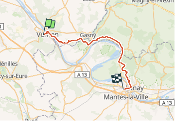
Ruta Senderismo de 37 km a descubrir en Normandía, Eure, Vernon. Esta ruta ha sido propuesta por chessyca.
Descripción
Rando féérique à l'automne
Attention un peu sportif !
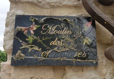
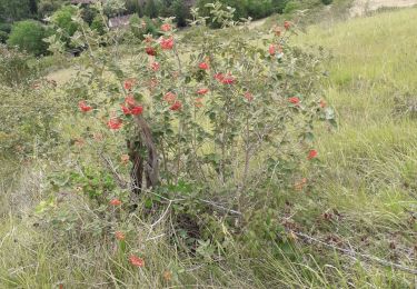
Localización
País:
France
Región :
Normandía
Departamento/provincia :
Eure
Municipio :
Vernon
Localidad:
Unknown
Salida:(Dec)
Salida:(UTM)
388850 ; 5438766 (31U) N.
Comentarios
Excursiones cerca
![Excursión Senderismo Giverny - 076-104-Giverny Matin 12km-526-030- - Photo](https://media.geolcdn.com/t/375/260/ext.jpg?maxdim=2&url=https%3A%2F%2Fmedia.geolcdn.com%2Ff%2F2efe6bca-4705-4852-8c25-252c9af261ae.jpg)
![Senderismo Senderismo](https://static1.geolcdn.com/sitytour/trail-icons/101.png)
076-104-Giverny Matin 12km-526-030-
Senderismo
Fácil
(2)
Giverny,
Normandía,
Eure,
France
![](/images/other/stat-length.png)
9,2 km | 11,5 km-effort
2h 32min
![](https://static1.geolcdn.com/siteimages/upload/files/16400158638029165_repeat_loop_refresh_sync_direction_icon.png)
Sí
![Excursión Senderismo La Chapelle-Longueville - Saint Just - Les coteaux de Seine - Photo](https://media.geolcdn.com/t/375/260/ext.jpg?maxdim=2&url=https%3A%2F%2Fstatic1.geolcdn.com%2Fsiteimages%2Fupload%2Ffiles%2F1553511878bg_sport_marche.png)
![Senderismo Senderismo](https://static1.geolcdn.com/sitytour/trail-icons/101.png)
Saint Just - Les coteaux de Seine
Senderismo
Fácil
(4)
La Chapelle-Longueville,
Normandía,
Eure,
France
![](/images/other/stat-length.png)
10,5 km | 13,8 km-effort
2h 57min
![](https://static1.geolcdn.com/siteimages/upload/files/16400158638029165_repeat_loop_refresh_sync_direction_icon.png)
Sí
![Excursión Senderismo Giverny - Giverny Le lézard vert - Photo](https://media.geolcdn.com/t/375/260/ext.jpg?maxdim=2&url=https%3A%2F%2Fmedia.geolcdn.com%2Ff%2Fb5c62cc3-3474-47fb-9b85-16cd33879457.jpg)
![Senderismo Senderismo](https://static1.geolcdn.com/sitytour/trail-icons/101.png)
Giverny Le lézard vert
Senderismo
Difícil
Giverny,
Normandía,
Eure,
France
![](/images/other/stat-length.png)
5,7 km | 7,5 km-effort
1h 57min
![](https://static1.geolcdn.com/siteimages/upload/files/16400158638029165_repeat_loop_refresh_sync_direction_icon.png)
No
![Excursión Senderismo Giverny - Giverny : les coteaux vers le Vexin 13 km - Photo](https://media.geolcdn.com/t/375/260/ext.jpg?maxdim=2&url=https%3A%2F%2Fmedia.geolcdn.com%2Ff%2Fc82fb9e5-5a3f-476d-97d5-3fb681dd4a31.jpg)
![Senderismo Senderismo](https://static1.geolcdn.com/sitytour/trail-icons/101.png)
Giverny : les coteaux vers le Vexin 13 km
Senderismo
Muy fácil
Giverny,
Normandía,
Eure,
France
![](/images/other/stat-length.png)
14,7 km | 17,8 km-effort
4h 51min
![](https://static1.geolcdn.com/siteimages/upload/files/16400158638029165_repeat_loop_refresh_sync_direction_icon.png)
No
![Excursión Motor Giverny - Giverny , les Coteaux avril 2019 - Photo](https://media.geolcdn.com/t/375/260/ext.jpg?maxdim=2&url=https%3A%2F%2Fservices.sitytrail.com%2FGeolivesWS%2FDownloadMedia.ashx%3FTrailID%3D1143131%26Media%3Dfix__20190408160534.jpg)
![Motor Motor](https://static1.geolcdn.com/sitytour/trail-icons/400.png)
Giverny , les Coteaux avril 2019
Motor
Medio
Giverny,
Normandía,
Eure,
France
![](/images/other/stat-length.png)
13,6 km | 16,5 km-effort
3h 28min
![](https://static1.geolcdn.com/siteimages/upload/files/16400158638029165_repeat_loop_refresh_sync_direction_icon.png)
No
![Excursión Motor Giverny - Giverny , les Coteaux avril 2019 - Photo](https://media.geolcdn.com/t/375/260/ext.jpg?maxdim=2&url=https%3A%2F%2Fservices.sitytrail.com%2FGeolivesWS%2FDownloadMedia.ashx%3FTrailID%3D1134663%26Media%3Dfix__20190408160534.jpg)
![Motor Motor](https://static1.geolcdn.com/sitytour/trail-icons/400.png)
Giverny , les Coteaux avril 2019
Motor
Medio
Giverny,
Normandía,
Eure,
France
![](/images/other/stat-length.png)
13,6 km | 16,5 km-effort
3h 28min
![](https://static1.geolcdn.com/siteimages/upload/files/16400158638029165_repeat_loop_refresh_sync_direction_icon.png)
No
![Excursión Motor Giverny - Giverny , les Coteaux avril 2019 - Photo](https://media.geolcdn.com/t/375/260/ext.jpg?maxdim=2&url=https%3A%2F%2Fservices.sitytrail.com%2FGeolivesWS%2FDownloadMedia.ashx%3FTrailID%3D1132418%26Media%3Dfix__20190408160534.jpg)
![Motor Motor](https://static1.geolcdn.com/sitytour/trail-icons/400.png)
Giverny , les Coteaux avril 2019
Motor
Medio
Giverny,
Normandía,
Eure,
France
![](/images/other/stat-length.png)
13,6 km | 16,5 km-effort
3h 28min
![](https://static1.geolcdn.com/siteimages/upload/files/16400158638029165_repeat_loop_refresh_sync_direction_icon.png)
No
![Excursión Bici de montaña Vernon - Les prés de Vernonnet - Vernon - Photo](https://media.geolcdn.com/t/375/260/ext.jpg?maxdim=2&url=https%3A%2F%2Fservices.sitytrail.com%2FGeolivesWS%2FDownloadMedia.ashx%3FTrailID%3D112611%26Media%3D11135_5.jpg)
![Bici de montaña Bici de montaña](https://static1.geolcdn.com/sitytour/trail-icons/202.png)
Les prés de Vernonnet - Vernon
Bici de montaña
Fácil
Vernon,
Normandía,
Eure,
France
![](/images/other/stat-length.png)
3,3 km | 3,7 km-effort
19min
![](https://static1.geolcdn.com/siteimages/upload/files/16400158638029165_repeat_loop_refresh_sync_direction_icon.png)
Sí
![Excursión Senderismo Vernon - Les prés de Vernonnet - Vernon - Photo](https://media.geolcdn.com/t/375/260/ext.jpg?maxdim=2&url=https%3A%2F%2Fservices.sitytrail.com%2FGeolivesWS%2FDownloadMedia.ashx%3FTrailID%3D112610%26Media%3D11135_5.jpg)
![Senderismo Senderismo](https://static1.geolcdn.com/sitytour/trail-icons/101.png)
Les prés de Vernonnet - Vernon
Senderismo
Fácil
Vernon,
Normandía,
Eure,
France
![](/images/other/stat-length.png)
3,3 km | 3,7 km-effort
49min
![](https://static1.geolcdn.com/siteimages/upload/files/16400158638029165_repeat_loop_refresh_sync_direction_icon.png)
Sí