Utah, États-Unis : Les meilleures randonnées, itinéraires, parcours, balades et promenades

Utah : découvrez les meilleures randonnées : 28 pédestres. Tous ces circuits, parcours, itinéraires et activités en plein air sont disponibles dans nos applications SityTrail pour smartphones et tablettes.


Les meilleurs parcours (36)

Randonnée Marche  - chesler park via joint trail  - Photo
Marche 18.303
Km

Marche

Difficile
, Utah, San Juan County, États-Unis
18,3 km | 25 km-effort
6h 39min
525 m
531 m
Oui
phi14

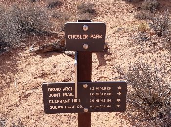
• Randonnée extraordinaire au coeur des Needles. A faire dans le sens anti-horaire.Moins difficile. Ne pas la faire par...

Randonnée Marche  - lower calf creek falls - Photo
Marche 5.257
Km

Marche

Facile
, Utah, Garfield County, États-Unis
5,3 km | 8,3 km-effort
1h 47min
253 m
153 m
Non
phi14

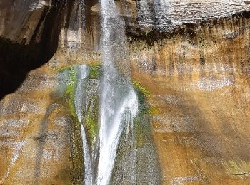
• Très belle balade avec à l'arrivée une superbe chute d'eau. 10.6 km AR

Randonnée Marche  - navaro knobs - Photo
Marche 7.739
Km

Marche

Difficile
, Utah, Wayne County, États-Unis
7,7 km | 12,8 km-effort
4h 0min
488 m
50 m
Non
phi14

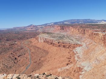
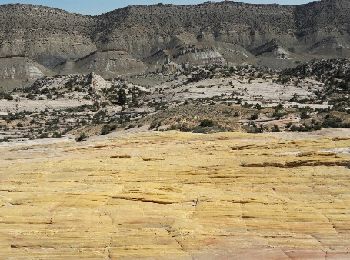
• Parcours magnifique au coeur de Capitol reef.Superbes vues tout le long.15 km AR. Le sommet est l'endroit idéal pour ...

Randonnée Marche  - Angel's landing - Photo
Marche 9.618
Km

Marche

Difficile
, Utah, Washington County, États-Unis
9,6 km | 23 km-effort
4h 58min
1001 m
1002 m
Oui
phi14

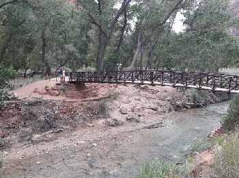
• C'est LA rando à faire à Zion. Splendide !!! Attention, sujet au vertige s'abstenir, la fin se fait sur une crête av...

Randonnée Marche  - Yellow Rock  - Photo
Marche 5.868
Km

Marche

Moyen
, Utah, Kane County, États-Unis
5,9 km | 9,3 km-effort
2h 10min
255 m
255 m
Oui
phi14

• Superbe

Randonnée Marche  - peek a boo loop - Photo
Marche 11.149
Km

Marche

Moyen
, Utah, Garfield County, États-Unis
11,1 km | 17,4 km-effort
4h 22min
469 m
469 m
Oui
phi14

• MAGNIFIQUE !!!

Randonnée Marche  - devil's Garden  - Photo
Marche 10.731
Km

Marche

Moyen
, Utah, Grand County, États-Unis
10,7 km | 14,4 km-effort
3h 14min
273 m
277 m
Oui
phi14

• superbe randonnée. faire le primitive trail à la descente.

Randonnée Marche  - SityTrail - Dead Hirse Point Visitor Center to Malboro Point - Photo
Marche 10.142
Km

Marche

Facile
, Utah, San Juan County, États-Unis
10,1 km | 11,6 km-effort
Inconnu
106 m
107 m
Non
rafa77

• rejoindre trailhezd Marlboro Point

Randonnée Marche  - Bryce canyon - Photo
Marche 10.922
Km

Marche

Moyen
, Utah, Garfield County, États-Unis
10,9 km | 16,7 km-effort
3h 54min
429 m
446 m
Non
francoisgaressus

• vert Nice

Randonnée Moteur  - Dead Horse Point Visitor Center to Malboro Point - Photo
Moteur 10.142
Km

Moteur

Moyen
, Utah, Grand County, États-Unis
10,1 km | 11,6 km-effort
22min
107 m
106 m
Non
rafa77

• rejoindre trailhed Marlboro Point Trace enregistrée dans le sens inverse

Randonnée 4x4  - Dead Horse Point  to Malboro Point - Photo
4x4 10.142
Km

4x4

Moyen
, Utah, Grand County, États-Unis
10,1 km | 11,6 km-effort
Inconnu
107 m
106 m
Non
rafa77

• Rejoindre le trailhed Marlboro Point depuis le camping de Dead Horse Point

Randonnée Marche  - Delicate Arch - Photo
Marche 5.1
Km

Marche

Moyen
, Utah, Grand County, États-Unis
5,1 km | 7,5 km-effort
1h 33min
182 m
182 m
Oui
Lobin

• randonnée au coucher de soleil. très sympathique

Randonnée Marche  - devil's garden et retour par le primitive trail - Photo
Marche 10.655
Km

Marche

Difficile
, Utah, Grand County, États-Unis
10,7 km | 14,3 km-effort
3h 21min
276 m
275 m
Oui
Lobin

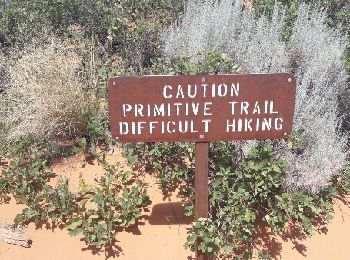
• superbe randonnée surtout le début du primitive trail (Après double arch). partir tôt le matin car les couleurs dont ...

Randonnée Marche  - Queen-peekabo-novajo loop 9,7 km - Photo
Marche 9.7
Km

Marche

Difficile
, Utah, Garfield County, États-Unis
9,7 km | 15,6 km-effort
3h 24min
441 m
439 m
Non
Lobin

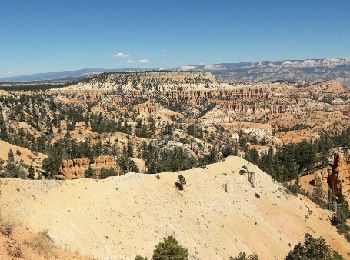
• superbe randonnée à Bryce canyon. départ de sunrise point et arrivée à sunset point. sublime balade au fond du canyon

Randonnée Marche  - Calf Creek - Photo
Marche 4.717
Km

Marche

Facile
, Utah, Garfield County, États-Unis
4,7 km | 6,9 km-effort
1h 46min
182 m
107 m
Non
raymondfn

• A Capitol Reef

Randonnée Marche  - Bryce Canyon Peek boo loop - Photo
Marche 8.411
Km

Marche

Très facile
, Utah, Garfield County, États-Unis
8,4 km | 14,1 km-effort
3h 10min
427 m
429 m
Oui
Maca8284

• Super

Randonnée Marche  - Capitol Reef  - Photo
Marche 5.921
Km

Marche

Facile
, Utah, Wayne County, États-Unis
5,9 km | 10,3 km-effort
1h 40min
326 m
322 m
Oui
Maca8284

• Super

Randonnée Marche Inconnu - Zyon NP watchman trail - Photo
Marche 5.499
Km

Marche

Facile
Inconnu, Utah, Washington County, États-Unis
5,5 km | 8,3 km-effort
1h 57min
214 m
204 m
Oui
Maca8284

• Super

Randonnée Moteur  - Lake Powell Rainbow Cruise - Photo
Moteur 131.086
Km

Moteur

Très facile
, Utah, Kane County, États-Unis
131 km | 134 km-effort
6h 41min
235 m
235 m
Non
Maca8284

• Wonderfull

Randonnée Marche  - Oservation point - Photo
Marche 5.391
Km

Marche

Très facile
, Utah, Kane County, États-Unis
5,4 km | 6,9 km-effort
1h 30min
115 m
106 m
Non
phi14

• Chemin d'acces à observation point le moins difficile. 11 km AR

20 randonnées affichées sur 36

Application GPS de randonnée GRATUITE

Logo SityTrail SityTrail

IGN / Instituts géographiques

Télécharger SityTrail sur l'App Store Télécharger SityTrail sur Google Play

Logo SityTrail SityTrail World

Le monde est à vous

Télécharger SityTrail sur l'App Store Télécharger SityTrail sur Google Play Télécharger SityTrail sur Huawei AppGallery

Activités

Régions proches

Fermer
Mes abonnements