![](/images/other/stat-length.png)
![Randonnée Vélo Cléry-Saint-André - Cléry Saint André - Photo](https://media.geolcdn.com/t/1900/400/ext.pjpeg?maxdim=2&url=https%3A%2F%2Fservices.sitytrail.com%2FGeolivesWS%2FDownloadMedia.ashx%3FTrailID%3D102657%26Media%3D3666_2.jpg)
Cléry Saint André
tracegps
Utilisateur
![Longueur](/images/other/stat-length.png)
Longueur
19,2 km
![Altitude max](https://static1.geolcdn.com/siteimages/upload/files/1508320355ic_sort_altitude_max_24dp.png)
Altitude max
108 m
![Dénivelé positif](https://static1.geolcdn.com/siteimages/upload/files/1508320355ic_sort_den_pos_24dp.png)
Dénivelé positif
91 m
![Km-Effort](/images/other/stat-length.png)
Km-Effort
20 km
![Altitude min](https://static1.geolcdn.com/siteimages/upload/files/1508320355ic_sort_altitude_min_24dp.png)
Altitude min
89 m
![Dénivelé négatif](https://static1.geolcdn.com/siteimages/upload/files/1508320355ic_sort_den_neg_24dp.png)
Dénivelé négatif
90 m
![Boucle](https://static1.geolcdn.com/siteimages/upload/files/16400158638029165_repeat_loop_refresh_sync_direction_icon.png)
Boucle
Oui
Date de création :
2014-12-10 00:00:00.0
Dernière modification :
2014-12-10 00:00:00.0
![Vélo](https://static1.geolcdn.com/sitytour/trail-icons/200.png)
1h45
Difficulté : Facile
![Scannez ce code QR pour ouvrir la randonnée dans l'application SityTrail](https://capi.geolives.com/qq0zvz2zws4bq2lad0pu/sitytour/trails/102657/qr.png?size=200)
Application GPS de randonnée GRATUITE
À propos
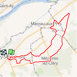
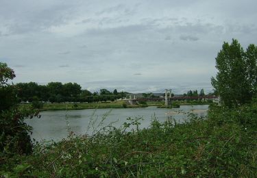
Randonnée Vélo de 19,2 km à découvrir à Centre-Val de Loire, Loiret, Cléry-Saint-André. Cette randonnée est proposée par tracegps.
Description
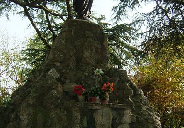
Sortie facile à faire en famille. Circuit sur route secondaire, très peu de circulation. Départ de la basilique (tombeau de Louis XI), arrêt à la butte des élus (statue au sommet). Vous roulerez entre les vignes (gris meunier) et les cerisiers.
Localisation
Pays :
France
Région :
Centre-Val de Loire
Département/Province :
Loiret
Commune :
Cléry-Saint-André
Localité :
Unknown
Départ:(Dec)
Départ:(UTM)
406818 ; 5297034 (31T) N.
Commentaires
Randonnées à proximité
![Randonnée Marche Saint-Ay - ST AY bords de Loire 2 - Photo](https://media.geolcdn.com/t/375/260/ext.jpg?maxdim=2&url=https%3A%2F%2Fstatic1.geolcdn.com%2Fsiteimages%2Fupload%2Ffiles%2F1553511878bg_sport_marche.png)
![Marche Marche](https://static1.geolcdn.com/sitytour/trail-icons/101.png)
ST AY bords de Loire 2
Marche
Difficile
(1)
Saint-Ay,
Centre-Val de Loire,
Loiret,
France
![](/images/other/stat-length.png)
12 km | 13,4 km-effort
2h 57min
![](https://static1.geolcdn.com/siteimages/upload/files/16400158638029165_repeat_loop_refresh_sync_direction_icon.png)
Oui
![Randonnée V.T.T. Mézières-lez-Cléry - Les élus Mézière - Photo](https://media.geolcdn.com/t/375/260/ext.jpg?maxdim=2&url=https%3A%2F%2Fservices.sitytrail.com%2FGeolivesWS%2FDownloadMedia.ashx%3FTrailID%3D102853%26Media%3D4026_6.jpg)
![V.T.T. V.T.T.](https://static1.geolcdn.com/sitytour/trail-icons/202.png)
Les élus Mézière
V.T.T.
Moyen
Mézières-lez-Cléry,
Centre-Val de Loire,
Loiret,
France
![](/images/other/stat-length.png)
13,1 km | 14,4 km-effort
1h 19min
![](https://static1.geolcdn.com/siteimages/upload/files/16400158638029165_repeat_loop_refresh_sync_direction_icon.png)
Oui
![Randonnée Marche Mézières-lez-Cléry - Les élus Mézière - Photo](https://media.geolcdn.com/t/375/260/ext.jpg?maxdim=2&url=https%3A%2F%2Fservices.sitytrail.com%2FGeolivesWS%2FDownloadMedia.ashx%3FTrailID%3D102852%26Media%3D4026_6.jpg)
![Marche Marche](https://static1.geolcdn.com/sitytour/trail-icons/101.png)
Les élus Mézière
Marche
Facile
Mézières-lez-Cléry,
Centre-Val de Loire,
Loiret,
France
![](/images/other/stat-length.png)
13,1 km | 14,4 km-effort
3h 30min
![](https://static1.geolcdn.com/siteimages/upload/files/16400158638029165_repeat_loop_refresh_sync_direction_icon.png)
Oui
![Randonnée Marche Mézières-lez-Cléry - mezieres fevrier 2023 - Photo](https://media.geolcdn.com/t/375/260/ext.jpg?maxdim=2&url=https%3A%2F%2Fmedia.geolcdn.com%2Ff%2F8e9bc008-e738-437d-a2d1-3e242f15dba1.jpg)
![Marche Marche](https://static1.geolcdn.com/sitytour/trail-icons/101.png)
mezieres fevrier 2023
Marche
Moyen
Mézières-lez-Cléry,
Centre-Val de Loire,
Loiret,
France
![](/images/other/stat-length.png)
10,6 km | 11,8 km-effort
2h 28min
![](https://static1.geolcdn.com/siteimages/upload/files/16400158638029165_repeat_loop_refresh_sync_direction_icon.png)
Oui
![Randonnée Marche Mézières-lez-Cléry - Mézières 6 juin 2021 - Photo](https://media.geolcdn.com/t/375/260/ext.jpg?maxdim=2&url=https%3A%2F%2Fmedia.geolcdn.com%2Ff%2F4ed21d7b-41f3-437d-bfd5-510784e977d6.jpg)
![Marche Marche](https://static1.geolcdn.com/sitytour/trail-icons/101.png)
Mézières 6 juin 2021
Marche
Moyen
Mézières-lez-Cléry,
Centre-Val de Loire,
Loiret,
France
![](/images/other/stat-length.png)
9,9 km | 10,9 km-effort
3h 7min
![](https://static1.geolcdn.com/siteimages/upload/files/16400158638029165_repeat_loop_refresh_sync_direction_icon.png)
Oui
![Randonnée V.T.T. Meung-sur-Loire - Les deux ponts - Meung sur Loire - Beaugency - Photo](https://media.geolcdn.com/t/375/260/ext.jpg?maxdim=2&url=https%3A%2F%2Fservices.sitytrail.com%2FGeolivesWS%2FDownloadMedia.ashx%3FTrailID%3D103577%26Media%3D5908_2.jpg)
![V.T.T. V.T.T.](https://static1.geolcdn.com/sitytour/trail-icons/202.png)
Les deux ponts - Meung sur Loire - Beaugency
V.T.T.
Moyen
Meung-sur-Loire,
Centre-Val de Loire,
Loiret,
France
![](/images/other/stat-length.png)
17,1 km | 18,4 km-effort
2h 0min
![](https://static1.geolcdn.com/siteimages/upload/files/16400158638029165_repeat_loop_refresh_sync_direction_icon.png)
Oui
![Randonnée Marche Meung-sur-Loire - Les deux ponts - Meung sur Loire - Beaugency - Photo](https://media.geolcdn.com/t/375/260/ext.jpg?maxdim=2&url=https%3A%2F%2Fservices.sitytrail.com%2FGeolivesWS%2FDownloadMedia.ashx%3FTrailID%3D103576%26Media%3D5908_2.jpg)
![Marche Marche](https://static1.geolcdn.com/sitytour/trail-icons/101.png)
Les deux ponts - Meung sur Loire - Beaugency
Marche
Moyen
Meung-sur-Loire,
Centre-Val de Loire,
Loiret,
France
![](/images/other/stat-length.png)
17,1 km | 18,4 km-effort
4h 0min
![](https://static1.geolcdn.com/siteimages/upload/files/16400158638029165_repeat_loop_refresh_sync_direction_icon.png)
Oui
![Randonnée Vélo de route Meung-sur-Loire - Beautency - Photo](https://media.geolcdn.com/t/375/260/ext.jpg?maxdim=2&url=https%3A%2F%2Fstatic1.geolcdn.com%2Fsiteimages%2Fupload%2Ffiles%2F1524743154velo.jpg)
![Vélo de route Vélo de route](https://static1.geolcdn.com/sitytour/trail-icons/201.png)
Beautency
Vélo de route
Meung-sur-Loire,
Centre-Val de Loire,
Loiret,
France
![](/images/other/stat-length.png)
18 km | 19,7 km-effort
1h 12min
![](https://static1.geolcdn.com/siteimages/upload/files/16400158638029165_repeat_loop_refresh_sync_direction_icon.png)
Oui
![Randonnée Marche Cléry-Saint-André - cler y3 - Photo](https://media.geolcdn.com/t/375/260/ext.jpg?maxdim=2&url=https%3A%2F%2Fstatic1.geolcdn.com%2Fsiteimages%2Fupload%2Ffiles%2F1553511878bg_sport_marche.png)
![Marche Marche](https://static1.geolcdn.com/sitytour/trail-icons/101.png)
cler y3
Marche
Facile
Cléry-Saint-André,
Centre-Val de Loire,
Loiret,
France
![](/images/other/stat-length.png)
4,3 km | 4,7 km-effort
1h 3min
![](https://static1.geolcdn.com/siteimages/upload/files/16400158638029165_repeat_loop_refresh_sync_direction_icon.png)
Oui