![](/images/other/stat-length.png)
![Randonnée Marche La Chapelle-Taillefert - Le Rocher de la Femme Perdue - La Chapelle-Taillefert - Photo](https://media.geolcdn.com/t/1900/400/ext.pjpeg?maxdim=2&url=https%3A%2F%2Fservices.sitytrail.com%2FGeolivesWS%2FDownloadMedia.ashx%3FTrailID%3D112877%26Media%3D12772_4.jpg)
Le Rocher de la Femme Perdue - La Chapelle-Taillefert
tracegps
Utilisateur
![Longueur](/images/other/stat-length.png)
Longueur
5,6 km
![Altitude max](https://static1.geolcdn.com/siteimages/upload/files/1508320355ic_sort_altitude_max_24dp.png)
Altitude max
612 m
![Dénivelé positif](https://static1.geolcdn.com/siteimages/upload/files/1508320355ic_sort_den_pos_24dp.png)
Dénivelé positif
158 m
![Km-Effort](/images/other/stat-length.png)
Km-Effort
7,7 km
![Altitude min](https://static1.geolcdn.com/siteimages/upload/files/1508320355ic_sort_altitude_min_24dp.png)
Altitude min
492 m
![Dénivelé négatif](https://static1.geolcdn.com/siteimages/upload/files/1508320355ic_sort_den_neg_24dp.png)
Dénivelé négatif
158 m
![Boucle](https://static1.geolcdn.com/siteimages/upload/files/16400158638029165_repeat_loop_refresh_sync_direction_icon.png)
Boucle
Oui
Date de création :
2014-12-10 00:00:00.0
Dernière modification :
2014-12-10 00:00:00.0
![Marche](https://static1.geolcdn.com/sitytour/trail-icons/101.png)
1h25
Difficulté : Facile
![Scannez ce code QR pour ouvrir la randonnée dans l'application SityTrail](https://capi.geolives.com/qq0zvz2zws4bq2lad0pu/sitytour/trails/112877/qr.png?size=200)
Application GPS de randonnée GRATUITE
À propos
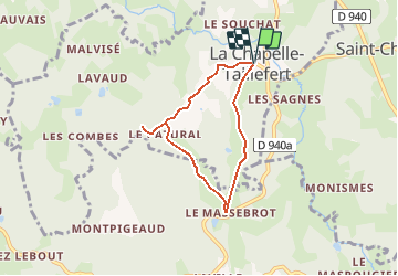
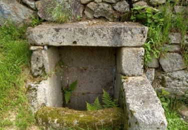
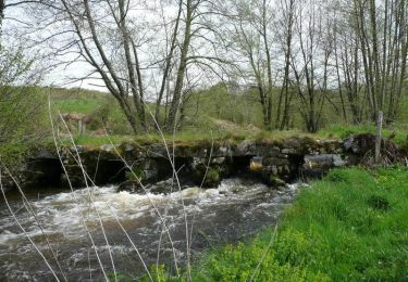
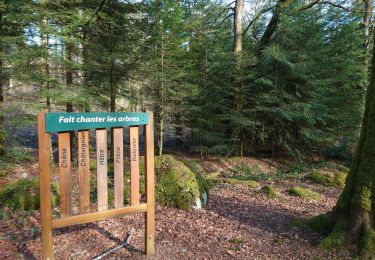
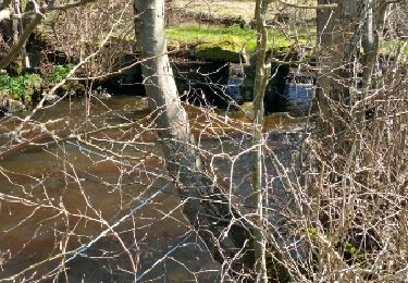
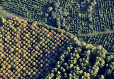
Randonnée Marche de 5,6 km à découvrir à Nouvelle-Aquitaine, Creuse, La Chapelle-Taillefert. Cette randonnée est proposée par tracegps.
Description
Circuit proposé par l'Office de Tourisme de Guéret et « Les amis de la Chapelle-Taillefert ». Départ de la mairie de La Chapelle-Taillefert. Retrouvez le circuit et son descriptif sur le site de l'Office de Tourisme de Guéret.
Localisation
Pays :
France
Région :
Nouvelle-Aquitaine
Département/Province :
Creuse
Commune :
La Chapelle-Taillefert
Localité :
Unknown
Départ:(Dec)
Départ:(UTM)
410287 ; 5105886 (31T) N.
Commentaires
Randonnées à proximité
![Randonnée Marche Sainte-Feyre - Les loups de Chabrières - Sainte Feyre - Photo](https://media.geolcdn.com/t/375/260/ext.jpg?maxdim=2&url=https%3A%2F%2Fservices.sitytrail.com%2FGeolivesWS%2FDownloadMedia.ashx%3FTrailID%3D112878%26Media%3D12773_5.jpg)
![Marche Marche](https://static1.geolcdn.com/sitytour/trail-icons/101.png)
Les loups de Chabrières - Sainte Feyre
Marche
Facile
(2)
Sainte-Feyre,
Nouvelle-Aquitaine,
Creuse,
France
![](/images/other/stat-length.png)
6,5 km | 9,5 km-effort
2h 0min
![](https://static1.geolcdn.com/siteimages/upload/files/16400158638029165_repeat_loop_refresh_sync_direction_icon.png)
Oui
![Randonnée Marche nordique Sainte-Feyre - Meyrat Perabout Parc à Loups 11.1k - Photo](https://media.geolcdn.com/t/375/260/ext.jpg?maxdim=2&url=https%3A%2F%2Fmedia.geolcdn.com%2Ff%2F8f473578-907f-4b42-806c-6e595a3ef44a.jpg)
![Marche nordique Marche nordique](https://static1.geolcdn.com/sitytour/trail-icons/102.png)
Meyrat Perabout Parc à Loups 11.1k
Marche nordique
Difficile
(1)
Sainte-Feyre,
Nouvelle-Aquitaine,
Creuse,
France
![](/images/other/stat-length.png)
11,1 km | 15,4 km-effort
2h 30min
![](https://static1.geolcdn.com/siteimages/upload/files/16400158638029165_repeat_loop_refresh_sync_direction_icon.png)
Oui
![Randonnée Marche Sainte-Feyre - Pierres et Légendes - Sainte-Feyre - Photo](https://media.geolcdn.com/t/375/260/ext.jpg?maxdim=2&url=https%3A%2F%2Fservices.sitytrail.com%2FGeolivesWS%2FDownloadMedia.ashx%3FTrailID%3D118667%26Media%3D12830_5.jpg)
![Marche Marche](https://static1.geolcdn.com/sitytour/trail-icons/101.png)
Pierres et Légendes - Sainte-Feyre
Marche
Difficile
Sainte-Feyre,
Nouvelle-Aquitaine,
Creuse,
France
![](/images/other/stat-length.png)
8,5 km | 11,9 km-effort
3h 0min
![](https://static1.geolcdn.com/siteimages/upload/files/16400158638029165_repeat_loop_refresh_sync_direction_icon.png)
Oui
![Randonnée Marche Savennes - La Croix de Reillat - Savennes - Photo](https://media.geolcdn.com/t/375/260/ext.jpg?maxdim=2&url=https%3A%2F%2Fservices.sitytrail.com%2FGeolivesWS%2FDownloadMedia.ashx%3FTrailID%3D118665%26Media%3D12828_3.jpg)
![Marche Marche](https://static1.geolcdn.com/sitytour/trail-icons/101.png)
La Croix de Reillat - Savennes
Marche
Facile
Savennes,
Nouvelle-Aquitaine,
Creuse,
France
![](/images/other/stat-length.png)
6,7 km | 8,7 km-effort
2h 0min
![](https://static1.geolcdn.com/siteimages/upload/files/16400158638029165_repeat_loop_refresh_sync_direction_icon.png)
Oui
![Randonnée Marche Savennes - Le chemin des Vergnes - Savennes - Photo](https://media.geolcdn.com/t/375/260/ext.jpg?maxdim=2&url=https%3A%2F%2Fservices.sitytrail.com%2FGeolivesWS%2FDownloadMedia.ashx%3FTrailID%3D118661%26Media%3D12824_3.jpg)
![Marche Marche](https://static1.geolcdn.com/sitytour/trail-icons/101.png)
Le chemin des Vergnes - Savennes
Marche
Moyen
Savennes,
Nouvelle-Aquitaine,
Creuse,
France
![](/images/other/stat-length.png)
8,2 km | 11,5 km-effort
2h 30min
![](https://static1.geolcdn.com/siteimages/upload/files/16400158638029165_repeat_loop_refresh_sync_direction_icon.png)
Oui
![Randonnée Marche La Chapelle-Taillefert - Les cascades de la Rebeyrolle - La Chapelle-Taillefert - Photo](https://media.geolcdn.com/t/375/260/ext.jpg?maxdim=2&url=https%3A%2F%2Fservices.sitytrail.com%2FGeolivesWS%2FDownloadMedia.ashx%3FTrailID%3D112889%26Media%3D12794_5.jpg)
![Marche Marche](https://static1.geolcdn.com/sitytour/trail-icons/101.png)
Les cascades de la Rebeyrolle - La Chapelle-Taillefert
Marche
Très difficile
La Chapelle-Taillefert,
Nouvelle-Aquitaine,
Creuse,
France
![](/images/other/stat-length.png)
15,1 km | 20 km-effort
4h 30min
![](https://static1.geolcdn.com/siteimages/upload/files/16400158638029165_repeat_loop_refresh_sync_direction_icon.png)
Oui
![Randonnée Marche nordique Guéret - sentier rando santé - Photo](https://media.geolcdn.com/t/375/260/ext.jpg?maxdim=2&url=https%3A%2F%2Fmedia.geolcdn.com%2Ff%2Fcede7158-cf32-4d4d-8b5b-47e7cb6bfd08.jpg)
![Marche nordique Marche nordique](https://static1.geolcdn.com/sitytour/trail-icons/102.png)
sentier rando santé
Marche nordique
Très facile
Guéret,
Nouvelle-Aquitaine,
Creuse,
France
![](/images/other/stat-length.png)
4,6 km | 6,3 km-effort
54min
![](https://static1.geolcdn.com/siteimages/upload/files/16400158638029165_repeat_loop_refresh_sync_direction_icon.png)
Oui
![Randonnée Autre activité Saint-Victor-en-Marche - gartempe1 - Photo](https://media.geolcdn.com/t/375/260/ext.jpg?maxdim=2&url=https%3A%2F%2Fservices.sitytrail.com%2FGeolivesWS%2FDownloadMedia.ashx%3FTrailID%3D458099%26Media%3Dfix__20150407143112.jpg)
![Autre activité Autre activité](https://static1.geolcdn.com/sitytour/trail-icons/900.png)
gartempe1
Autre activité
Très facile
Saint-Victor-en-Marche,
Nouvelle-Aquitaine,
Creuse,
France
![](/images/other/stat-length.png)
17,9 km | 23 km-effort
2h 44min
![](https://static1.geolcdn.com/siteimages/upload/files/16400158638029165_repeat_loop_refresh_sync_direction_icon.png)
Non
![Randonnée V.T.T. Sainte-Feyre - Espace VTT FFC des Monts de Guéret - Circuit N° 32 - Badant - Photo](https://media.geolcdn.com/t/375/260/ext.jpg?maxdim=2&url=https%3A%2F%2Fservices.sitytrail.com%2FGeolivesWS%2FDownloadMedia.ashx%3FTrailID%3D316947%26Media%3D16060_1.jpg)
![V.T.T. V.T.T.](https://static1.geolcdn.com/sitytour/trail-icons/202.png)
Espace VTT FFC des Monts de Guéret - Circuit N° 32 - Badant
V.T.T.
Très difficile
Sainte-Feyre,
Nouvelle-Aquitaine,
Creuse,
France
![](/images/other/stat-length.png)
17,4 km | 25 km-effort
2h 0min
![](https://static1.geolcdn.com/siteimages/upload/files/16400158638029165_repeat_loop_refresh_sync_direction_icon.png)
Oui