![](/images/other/stat-length.png)
![Randonnée Vélo Le Crotoy - Crotoy - Marquenterre - Photo](https://media.geolcdn.com/t/1900/400/ext.pjpeg?maxdim=2&url=https%3A%2F%2Fstatic1.geolcdn.com%2Fsiteimages%2Fupload%2Ffiles%2F1524743154velo.jpg)
Crotoy - Marquenterre
jacques.moulin@hotmail.com
Utilisateur
![Longueur](/images/other/stat-length.png)
Longueur
18,3 km
![Altitude max](https://static1.geolcdn.com/siteimages/upload/files/1508320355ic_sort_altitude_max_24dp.png)
Altitude max
12 m
![Dénivelé positif](https://static1.geolcdn.com/siteimages/upload/files/1508320355ic_sort_den_pos_24dp.png)
Dénivelé positif
67 m
![Km-Effort](/images/other/stat-length.png)
Km-Effort
19,2 km
![Altitude min](https://static1.geolcdn.com/siteimages/upload/files/1508320355ic_sort_altitude_min_24dp.png)
Altitude min
1 m
![Dénivelé négatif](https://static1.geolcdn.com/siteimages/upload/files/1508320355ic_sort_den_neg_24dp.png)
Dénivelé négatif
68 m
![Boucle](https://static1.geolcdn.com/siteimages/upload/files/16400158638029165_repeat_loop_refresh_sync_direction_icon.png)
Boucle
Oui
Date de création :
2014-12-10 00:00:00.0
Dernière modification :
2014-12-10 00:00:00.0
![Vélo](https://static1.geolcdn.com/sitytour/trail-icons/200.png)
1h08
Difficulté : Moyen
![Scannez ce code QR pour ouvrir la randonnée dans l'application SityTrail](https://capi.geolives.com/qq0zvz2zws4bq2lad0pu/sitytour/trails/183042/qr.png?size=200)
Application GPS de randonnée GRATUITE
À propos
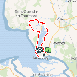
Randonnée Vélo de 18,3 km à découvrir à Hauts-de-France, Somme, Le Crotoy. Cette randonnée est proposée par jacques.moulin@hotmail.com.
Description
Du Crotoy vers St Firmin en longeant les gravières, puis direction Marquenterre. Retour par le sentier des bergers, puis Enclave du Champ Neuf jusqu'à St Firmin. Retour au Croty par la rue des mouettes.
Localisation
Pays :
France
Région :
Hauts-de-France
Département/Province :
Somme
Commune :
Le Crotoy
Localité :
Unknown
Départ:(Dec)
Départ:(UTM)
402387 ; 5563747 (31U) N.
Commentaires
Randonnées à proximité
![Randonnée Marche Saint-Valery-sur-Somme - Balade à Saint-Valéry-sur-Somme - Photo](https://media.geolcdn.com/t/375/260/ext.jpg?maxdim=2&url=https%3A%2F%2Fservices.sitytrail.com%2FGeolivesWS%2FDownloadMedia.ashx%3FTrailID%3D438142%26Media%3Dfed88654-3b60-4043-bb2e-e5c8c6773117.JPG)
![Marche Marche](https://static1.geolcdn.com/sitytour/trail-icons/101.png)
Balade à Saint-Valéry-sur-Somme
Marche
Facile
(4)
Saint-Valery-sur-Somme,
Hauts-de-France,
Somme,
France
![](/images/other/stat-length.png)
10,4 km | 12,2 km-effort
2h 41min
![](https://static1.geolcdn.com/siteimages/upload/files/16400158638029165_repeat_loop_refresh_sync_direction_icon.png)
Oui
![Randonnée Marche Le Crotoy - LP80_LaMaye_Reserve-du-Marquenterre_6km - Photo](https://media.geolcdn.com/t/375/260/ext.jpg?maxdim=2&url=https%3A%2F%2Fmedia.geolcdn.com%2Ff%2Fcef91e86-689f-4bd7-8591-33e387b29cb5.jpg)
![Marche Marche](https://static1.geolcdn.com/sitytour/trail-icons/101.png)
LP80_LaMaye_Reserve-du-Marquenterre_6km
Marche
Moyen
(2)
Le Crotoy,
Hauts-de-France,
Somme,
France
![](/images/other/stat-length.png)
6 km | 6,1 km-effort
1h 23min
![](https://static1.geolcdn.com/siteimages/upload/files/16400158638029165_repeat_loop_refresh_sync_direction_icon.png)
Oui
![Randonnée Marche Cayeux-sur-Mer - Le Hourdel V2 - Photo](https://media.geolcdn.com/t/375/260/ext.jpg?maxdim=2&url=https%3A%2F%2Fservices.sitytrail.com%2FGeolivesWS%2FDownloadMedia.ashx%3FTrailID%3D108609%26Media%3D1517_1.jpg)
![Marche Marche](https://static1.geolcdn.com/sitytour/trail-icons/101.png)
Le Hourdel V2
Marche
Difficile
(1)
Cayeux-sur-Mer,
Hauts-de-France,
Somme,
France
![](/images/other/stat-length.png)
8 km | 8,4 km-effort
2h 30min
![](https://static1.geolcdn.com/siteimages/upload/files/16400158638029165_repeat_loop_refresh_sync_direction_icon.png)
Oui
![Randonnée Marche Saint-Valery-sur-Somme - Balade à Saint-Valery sur Somme - Photo](https://media.geolcdn.com/t/375/260/ext.jpg?maxdim=2&url=https%3A%2F%2Fservices.sitytrail.com%2FGeolivesWS%2FDownloadMedia.ashx%3FTrailID%3D108607%26Media%3D1515_1.jpg)
![Marche Marche](https://static1.geolcdn.com/sitytour/trail-icons/101.png)
Balade à Saint-Valery sur Somme
Marche
Moyen
(3)
Saint-Valery-sur-Somme,
Hauts-de-France,
Somme,
France
![](/images/other/stat-length.png)
7,1 km | 8,6 km-effort
2h 19min
![](https://static1.geolcdn.com/siteimages/upload/files/16400158638029165_repeat_loop_refresh_sync_direction_icon.png)
Oui
![Randonnée Marche Favières - Circuit de Morlay - Photo](https://media.geolcdn.com/t/375/260/ext.jpg?maxdim=2&url=https%3A%2F%2Fservices.sitytrail.com%2FGeolivesWS%2FDownloadMedia.ashx%3FTrailID%3D108602%26Media%3D1510_1.jpg)
![Marche Marche](https://static1.geolcdn.com/sitytour/trail-icons/101.png)
Circuit de Morlay
Marche
Difficile
(1)
Favières,
Hauts-de-France,
Somme,
France
![](/images/other/stat-length.png)
12,4 km | 12,8 km-effort
4h 0min
![](https://static1.geolcdn.com/siteimages/upload/files/16400158638029165_repeat_loop_refresh_sync_direction_icon.png)
Oui
![Randonnée Marche Saint-Valery-sur-Somme - Traversée Baie de Somme - St Valery - Le Crotoy - Photo](https://media.geolcdn.com/t/375/260/ext.jpg?maxdim=2&url=https%3A%2F%2Fmedia.geolcdn.com%2Ff%2F486a482e-6345-45f3-b041-b66bc4ab348e.jpg)
![Marche Marche](https://static1.geolcdn.com/sitytour/trail-icons/101.png)
Traversée Baie de Somme - St Valery - Le Crotoy
Marche
Moyen
Saint-Valery-sur-Somme,
Hauts-de-France,
Somme,
France
![](/images/other/stat-length.png)
8,5 km | 8,8 km-effort
2h 0min
![](https://static1.geolcdn.com/siteimages/upload/files/16400158638029165_repeat_loop_refresh_sync_direction_icon.png)
Non
![Randonnée Marche Saint-Valery-sur-Somme - w-frankrijk-over-dijken-en-kwelders - Photo](https://media.geolcdn.com/t/375/260/ext.jpg?maxdim=2&url=https%3A%2F%2Fstatic1.geolcdn.com%2Fsiteimages%2Fupload%2Ffiles%2F1553511878bg_sport_marche.png)
![Marche Marche](https://static1.geolcdn.com/sitytour/trail-icons/101.png)
w-frankrijk-over-dijken-en-kwelders
Marche
Très facile
(2)
Saint-Valery-sur-Somme,
Hauts-de-France,
Somme,
France
![](/images/other/stat-length.png)
13,8 km | 14,9 km-effort
Inconnu
![](https://static1.geolcdn.com/siteimages/upload/files/16400158638029165_repeat_loop_refresh_sync_direction_icon.png)
Oui
![Randonnée V.T.T. Saint-Valery-sur-Somme - Gravelot Baie de sommes - Photo](https://media.geolcdn.com/t/375/260/ext.jpg?maxdim=2&url=https%3A%2F%2Fstatic1.geolcdn.com%2Fsiteimages%2Fupload%2Ffiles%2F1524743154velo.jpg)
![V.T.T. V.T.T.](https://static1.geolcdn.com/sitytour/trail-icons/202.png)
Gravelot Baie de sommes
V.T.T.
Facile
(1)
Saint-Valery-sur-Somme,
Hauts-de-France,
Somme,
France
![](/images/other/stat-length.png)
44 km | 47 km-effort
4h 56min
![](https://static1.geolcdn.com/siteimages/upload/files/16400158638029165_repeat_loop_refresh_sync_direction_icon.png)
Oui
![Randonnée Cheval Le Crotoy - de la Maye vers marquenterre - Photo](https://media.geolcdn.com/t/375/260/ext.jpg?maxdim=2&url=https%3A%2F%2Fstatic1.geolcdn.com%2Fsiteimages%2Fupload%2Ffiles%2F1524743154cheval.jpg)
![Cheval Cheval](https://static1.geolcdn.com/sitytour/trail-icons/300.png)
de la Maye vers marquenterre
Cheval
Très facile
(4)
Le Crotoy,
Hauts-de-France,
Somme,
France
![](/images/other/stat-length.png)
20 km | 21 km-effort
2h 43min
![](https://static1.geolcdn.com/siteimages/upload/files/16400158638029165_repeat_loop_refresh_sync_direction_icon.png)
Non
genial