![](/images/other/stat-length.png)
![Randonnée V.T.T. Ramatuelle - Ramatuelle moulins de Paillas et Patapans.gpx - Photo](https://media.geolcdn.com/t/1900/400/ext.pjpeg?maxdim=2&url=https%3A%2F%2Fstatic1.geolcdn.com%2Fsiteimages%2Fupload%2Ffiles%2F1524743154velo.jpg)
Ramatuelle moulins de Paillas et Patapans.gpx
ves
Utilisateur
![Longueur](/images/other/stat-length.png)
Longueur
19,8 km
![Altitude max](https://static1.geolcdn.com/siteimages/upload/files/1508320355ic_sort_altitude_max_24dp.png)
Altitude max
316 m
![Dénivelé positif](https://static1.geolcdn.com/siteimages/upload/files/1508320355ic_sort_den_pos_24dp.png)
Dénivelé positif
401 m
![Km-Effort](/images/other/stat-length.png)
Km-Effort
26 km
![Altitude min](https://static1.geolcdn.com/siteimages/upload/files/1508320355ic_sort_altitude_min_24dp.png)
Altitude min
17 m
![Dénivelé négatif](https://static1.geolcdn.com/siteimages/upload/files/1508320355ic_sort_den_neg_24dp.png)
Dénivelé négatif
657 m
![Boucle](https://static1.geolcdn.com/siteimages/upload/files/16400158638029165_repeat_loop_refresh_sync_direction_icon.png)
Boucle
Non
Date de création :
2014-12-10 00:00:00.0
Dernière modification :
2014-12-10 00:00:00.0
![V.T.T.](https://static1.geolcdn.com/sitytour/trail-icons/202.png)
2h22
Difficulté : Moyen
![Scannez ce code QR pour ouvrir la randonnée dans l'application SityTrail](https://capi.geolives.com/qq0zvz2zws4bq2lad0pu/sitytour/trails/192020/qr.png?size=200)
Application GPS de randonnée GRATUITE
À propos
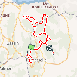
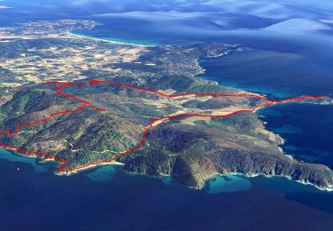
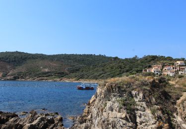
Randonnée V.T.T. de 19,8 km à découvrir à Provence-Alpes-Côte d'Azur, Var, Ramatuelle. Cette randonnée est proposée par ves.
Description
Sortie faite avec Pep's Spirit, n'hésitez pas à les contacter, leurs circuits et la bonne humeur vaut le détour. Attention, passages privés par endroits d'où guide de Pep's fortement conseillé.
Localisation
Pays :
France
Région :
Provence-Alpes-Côte d'Azur
Département/Province :
Var
Commune :
Ramatuelle
Localité :
Unknown
Départ:(Dec)
Départ:(UTM)
305276 ; 4788061 (32T) N.
Commentaires
Randonnées à proximité
![Randonnée A pied La Croix-Valmer - La Croix Valmer - Gigaro - Taillat - Collebasse - Gigaro - Photo](https://media.geolcdn.com/t/375/260/ext.jpg?maxdim=2&url=https%3A%2F%2Fmedia.geolcdn.com%2Ff%2Fa03cc7dc-d40c-427d-bc15-d4c3c8fead2d.jpg)
![A pied A pied](https://static1.geolcdn.com/sitytour/trail-icons/100.png)
La Croix Valmer - Gigaro - Taillat - Collebasse - Gigaro
A pied
Moyen
(1)
La Croix-Valmer,
Provence-Alpes-Côte d'Azur,
Var,
France
![](/images/other/stat-length.png)
15,2 km | 20 km-effort
6h 0min
![](https://static1.geolcdn.com/siteimages/upload/files/16400158638029165_repeat_loop_refresh_sync_direction_icon.png)
Oui
![Randonnée Marche Ramatuelle - chemin du littoral : Pampelone St Tropez - Photo](https://media.geolcdn.com/t/375/260/ext.jpg?maxdim=2&url=https%3A%2F%2Fservices.sitytrail.com%2FGeolivesWS%2FDownloadMedia.ashx%3FTrailID%3D200480%26Media%3D20130625091922.jpeg)
![Marche Marche](https://static1.geolcdn.com/sitytour/trail-icons/101.png)
chemin du littoral : Pampelone St Tropez
Marche
Facile
(3)
Ramatuelle,
Provence-Alpes-Côte d'Azur,
Var,
France
![](/images/other/stat-length.png)
13,2 km | 15,6 km-effort
3h 20min
![](https://static1.geolcdn.com/siteimages/upload/files/16400158638029165_repeat_loop_refresh_sync_direction_icon.png)
Non
![Randonnée Vélo électrique La Croix-Valmer - Rayol -Oppidum version 2 - Photo](https://media.geolcdn.com/t/375/260/ext.jpg?maxdim=2&url=https%3A%2F%2Fmedia.geolcdn.com%2Ff%2Ffc5cd018-661e-4f17-bef8-76baca0d8415.jpg)
![Vélo électrique Vélo électrique](https://static1.geolcdn.com/sitytour/trail-icons/205.png)
Rayol -Oppidum version 2
Vélo électrique
(1)
La Croix-Valmer,
Provence-Alpes-Côte d'Azur,
Var,
France
![](/images/other/stat-length.png)
40 km | 52 km-effort
2h 55min
![](https://static1.geolcdn.com/siteimages/upload/files/16400158638029165_repeat_loop_refresh_sync_direction_icon.png)
Oui
![Randonnée Marche La Croix-Valmer - LCV RANDO COURTE COLLINES - Photo](https://media.geolcdn.com/t/375/260/ext.jpg?maxdim=2&url=https%3A%2F%2Fstatic1.geolcdn.com%2Fsiteimages%2Fupload%2Ffiles%2F1553511878bg_sport_marche.png)
![Marche Marche](https://static1.geolcdn.com/sitytour/trail-icons/101.png)
LCV RANDO COURTE COLLINES
Marche
Difficile
(1)
La Croix-Valmer,
Provence-Alpes-Côte d'Azur,
Var,
France
![](/images/other/stat-length.png)
9,1 km | 13,2 km-effort
2h 59min
![](https://static1.geolcdn.com/siteimages/upload/files/16400158638029165_repeat_loop_refresh_sync_direction_icon.png)
Oui
![Randonnée V.T.T. Ramatuelle - Ramatuelle - Ballade dans et autour de Ramatuelle - Moulin de Paillas - La roulliere - Photo](https://media.geolcdn.com/t/375/260/ext.jpg?maxdim=2&url=https%3A%2F%2Fstatic1.geolcdn.com%2Fsiteimages%2Fupload%2Ffiles%2F1524743154velo.jpg)
![V.T.T. V.T.T.](https://static1.geolcdn.com/sitytour/trail-icons/202.png)
Ramatuelle - Ballade dans et autour de Ramatuelle - Moulin de Paillas - La ro...
V.T.T.
Moyen
(1)
Ramatuelle,
Provence-Alpes-Côte d'Azur,
Var,
France
![](/images/other/stat-length.png)
23 km | 30 km-effort
2h 3min
![](https://static1.geolcdn.com/siteimages/upload/files/16400158638029165_repeat_loop_refresh_sync_direction_icon.png)
Oui
![Randonnée Marche Cogolin - Gavotte- Bagueirède sud - Peinier - Bord de Mole - Photo](https://media.geolcdn.com/t/375/260/ext.jpg?maxdim=2&url=https%3A%2F%2Fstatic1.geolcdn.com%2Fsiteimages%2Fupload%2Ffiles%2F1553511878bg_sport_marche.png)
![Marche Marche](https://static1.geolcdn.com/sitytour/trail-icons/101.png)
Gavotte- Bagueirède sud - Peinier - Bord de Mole
Marche
Difficile
(1)
Cogolin,
Provence-Alpes-Côte d'Azur,
Var,
France
![](/images/other/stat-length.png)
12 km | 17,3 km-effort
5h 0min
![](https://static1.geolcdn.com/siteimages/upload/files/16400158638029165_repeat_loop_refresh_sync_direction_icon.png)
Oui
![Randonnée Vélo électrique La Croix-Valmer - Rayol -Oppidum - Photo](https://media.geolcdn.com/t/375/260/ext.jpg?maxdim=2&url=https%3A%2F%2Fmedia.geolcdn.com%2Ff%2Ffc5cd018-661e-4f17-bef8-76baca0d8415.jpg)
![Vélo électrique Vélo électrique](https://static1.geolcdn.com/sitytour/trail-icons/205.png)
Rayol -Oppidum
Vélo électrique
(1)
La Croix-Valmer,
Provence-Alpes-Côte d'Azur,
Var,
France
![](/images/other/stat-length.png)
40 km | 53 km-effort
2h 55min
![](https://static1.geolcdn.com/siteimages/upload/files/16400158638029165_repeat_loop_refresh_sync_direction_icon.png)
Oui
![Randonnée Marche Ramatuelle - Le cap Camarat - Photo](https://media.geolcdn.com/t/375/260/ext.jpg?maxdim=2&url=https%3A%2F%2Fservices.sitytrail.com%2FGeolivesWS%2FDownloadMedia.ashx%3FTrailID%3D787295%26Media%3D869e75b8-d08c-458a-b38d-0a864e88844b.JPG)
![Marche Marche](https://static1.geolcdn.com/sitytour/trail-icons/101.png)
Le cap Camarat
Marche
Moyen
(1)
Ramatuelle,
Provence-Alpes-Côte d'Azur,
Var,
France
![](/images/other/stat-length.png)
6,8 km | 8,6 km-effort
1h 58min
![](https://static1.geolcdn.com/siteimages/upload/files/16400158638029165_repeat_loop_refresh_sync_direction_icon.png)
Oui
![Randonnée V.T.T. Gassin - La Nartelle- depart Bourrian - Photo](https://media.geolcdn.com/t/375/260/ext.jpg?maxdim=2&url=https%3A%2F%2Fstatic1.geolcdn.com%2Fsiteimages%2Fupload%2Ffiles%2F1524743154velo.jpg)
![V.T.T. V.T.T.](https://static1.geolcdn.com/sitytour/trail-icons/202.png)
La Nartelle- depart Bourrian
V.T.T.
Moyen
(1)
Gassin,
Provence-Alpes-Côte d'Azur,
Var,
France
![](/images/other/stat-length.png)
24 km | 31 km-effort
3h 11min
![](https://static1.geolcdn.com/siteimages/upload/files/16400158638029165_repeat_loop_refresh_sync_direction_icon.png)
Oui