![](/images/other/stat-length.png)
![Randonnée Marche Bléré - Bléré Est - Photo](https://media.geolcdn.com/t/1900/400/ext.pjpeg?maxdim=2&url=https%3A%2F%2Fstatic1.geolcdn.com%2Fsiteimages%2Fupload%2Ffiles%2F1553511878bg_sport_marche.png)
Bléré Est
LEMENIO
Utilisateur
![Longueur](/images/other/stat-length.png)
Longueur
12,7 km
![Altitude max](https://static1.geolcdn.com/siteimages/upload/files/1508320355ic_sort_altitude_max_24dp.png)
Altitude max
105 m
![Dénivelé positif](https://static1.geolcdn.com/siteimages/upload/files/1508320355ic_sort_den_pos_24dp.png)
Dénivelé positif
123 m
![Km-Effort](/images/other/stat-length.png)
Km-Effort
14,4 km
![Altitude min](https://static1.geolcdn.com/siteimages/upload/files/1508320355ic_sort_altitude_min_24dp.png)
Altitude min
51 m
![Dénivelé négatif](https://static1.geolcdn.com/siteimages/upload/files/1508320355ic_sort_den_neg_24dp.png)
Dénivelé négatif
123 m
![Boucle](https://static1.geolcdn.com/siteimages/upload/files/16400158638029165_repeat_loop_refresh_sync_direction_icon.png)
Boucle
Non
Date de création :
2014-12-10 00:00:00.0
Dernière modification :
2014-12-10 00:00:00.0
![Marche](https://static1.geolcdn.com/sitytour/trail-icons/101.png)
3h00
Difficulté : Moyen
![Scannez ce code QR pour ouvrir la randonnée dans l'application SityTrail](https://capi.geolives.com/qq0zvz2zws4bq2lad0pu/sitytour/trails/227382/qr.png?size=200)
Application GPS de randonnée GRATUITE
À propos
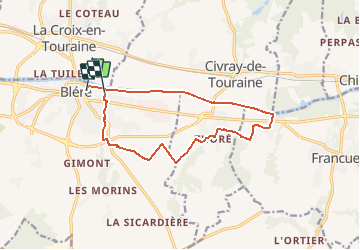
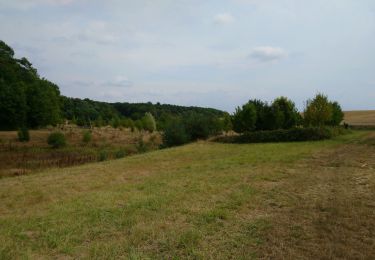
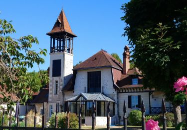
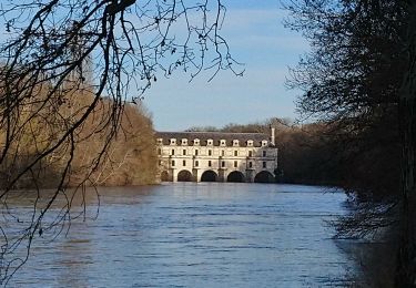
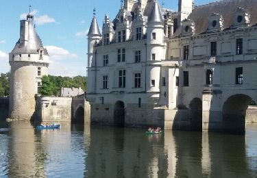
Randonnée Marche de 12,7 km à découvrir à Centre-Val de Loire, Indre-et-Loire, Bléré. Cette randonnée est proposée par LEMENIO.
Description
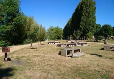
Départ depuis le terrain de camping. Vers la fin du parcours (voir balise sur carte)après le pont, monter le petit escalier du talus sur la gauche du pont.
Localisation
Pays :
France
Région :
Centre-Val de Loire
Département/Province :
Indre-et-Loire
Commune :
Bléré
Localité :
Unknown
Départ:(Dec)
Départ:(UTM)
348554 ; 5243578 (31T) N.
Commentaires
Randonnées à proximité
![Randonnée Marche Luzillé - les petits gars - Photo](https://media.geolcdn.com/t/375/260/ext.jpg?maxdim=2&url=https%3A%2F%2Fservices.sitytrail.com%2FGeolivesWS%2FDownloadMedia.ashx%3FTrailID%3D740867%26Media%3Dfix__20170427113816.jpg)
![Marche Marche](https://static1.geolcdn.com/sitytour/trail-icons/101.png)
les petits gars
Marche
Très facile
(1)
Luzillé,
Centre-Val de Loire,
Indre-et-Loire,
France
![](/images/other/stat-length.png)
6,7 km | 7,3 km-effort
2h 13min
![](https://static1.geolcdn.com/siteimages/upload/files/16400158638029165_repeat_loop_refresh_sync_direction_icon.png)
Oui
![Randonnée Marche Civray-de-Touraine - Civray-de-Touraine - boucle Thoré de 12.6km et boucle Civray de 6km - 18.6km 190m 4h25 - 2023 08 16 - Photo](https://media.geolcdn.com/t/375/260/ext.jpg?maxdim=2&url=https%3A%2F%2Fmedia.geolcdn.com%2Ff%2F93c6cdca-83ba-403b-ab65-7bff69e76619.jpg)
![Marche Marche](https://static1.geolcdn.com/sitytour/trail-icons/101.png)
Civray-de-Touraine - boucle Thoré de 12.6km et boucle Civray de 6km - 18.6km ...
Marche
Facile
Civray-de-Touraine,
Centre-Val de Loire,
Indre-et-Loire,
France
![](/images/other/stat-length.png)
18,4 km | 21 km-effort
4h 25min
![](https://static1.geolcdn.com/siteimages/upload/files/16400158638029165_repeat_loop_refresh_sync_direction_icon.png)
Oui
![Randonnée Marche La Croix-en-Touraine - la Croix-en-Touraine - 16.4km 150m 3h50 (30mn) - 2023 07 08 - Photo](https://media.geolcdn.com/t/375/260/ext.jpg?maxdim=2&url=https%3A%2F%2Fmedia.geolcdn.com%2Ff%2F2678fd2f-7ce4-496a-8544-610b3f2f9e63.jpg)
![Marche Marche](https://static1.geolcdn.com/sitytour/trail-icons/101.png)
la Croix-en-Touraine - 16.4km 150m 3h50 (30mn) - 2023 07 08
Marche
Difficile
La Croix-en-Touraine,
Centre-Val de Loire,
Indre-et-Loire,
France
![](/images/other/stat-length.png)
16,4 km | 18,5 km-effort
4h 11min
![](https://static1.geolcdn.com/siteimages/upload/files/16400158638029165_repeat_loop_refresh_sync_direction_icon.png)
Oui
![Randonnée Marche Dierre - Dierre - St-Martin-le-Beau - 15.9km 230m 3h35 - 2023 02 26 - Photo](https://media.geolcdn.com/t/375/260/ext.jpg?maxdim=2&url=https%3A%2F%2Fmedia.geolcdn.com%2Ff%2Ff1e8a642-9a7c-4bcc-aef6-e89c45620d53.jpg)
![Marche Marche](https://static1.geolcdn.com/sitytour/trail-icons/101.png)
Dierre - St-Martin-le-Beau - 15.9km 230m 3h35 - 2023 02 26
Marche
Facile
Dierre,
Centre-Val de Loire,
Indre-et-Loire,
France
![](/images/other/stat-length.png)
15,9 km | 19 km-effort
3h 35min
![](https://static1.geolcdn.com/siteimages/upload/files/16400158638029165_repeat_loop_refresh_sync_direction_icon.png)
Oui
![Randonnée Marche Bléré - Bléré - Fonds de Bout Ferré - 14.2km 145m 3h30 - 2022 08 15 - Photo](https://media.geolcdn.com/t/375/260/ext.jpg?maxdim=2&url=https%3A%2F%2Fmedia.geolcdn.com%2Ff%2F3f6831ff-189b-444c-8755-d6d9f4110c27.jpg)
![Marche Marche](https://static1.geolcdn.com/sitytour/trail-icons/101.png)
Bléré - Fonds de Bout Ferré - 14.2km 145m 3h30 - 2022 08 15
Marche
Facile
Bléré,
Centre-Val de Loire,
Indre-et-Loire,
France
![](/images/other/stat-length.png)
14,2 km | 16,2 km-effort
3h 30min
![](https://static1.geolcdn.com/siteimages/upload/files/16400158638029165_repeat_loop_refresh_sync_direction_icon.png)
Oui
![Randonnée Marche Bléré - Bléré - Fontenay - 15.9km 145m 3h45 - 2022 07 31 - Photo](https://media.geolcdn.com/t/375/260/ext.jpg?maxdim=2&url=https%3A%2F%2Fmedia.geolcdn.com%2Ff%2F1cdd1517-7a96-427a-95fc-8223942e32de.jpg)
![Marche Marche](https://static1.geolcdn.com/sitytour/trail-icons/101.png)
Bléré - Fontenay - 15.9km 145m 3h45 - 2022 07 31
Marche
Facile
Bléré,
Centre-Val de Loire,
Indre-et-Loire,
France
![](/images/other/stat-length.png)
15,9 km | 17,8 km-effort
3h 45min
![](https://static1.geolcdn.com/siteimages/upload/files/16400158638029165_repeat_loop_refresh_sync_direction_icon.png)
Oui
![Randonnée Marche Francueil - Chenonceaux - GR41 Francueil - 12.7km 160m 2h45 - 2022 01 01 - Photo](https://media.geolcdn.com/t/375/260/ext.jpg?maxdim=2&url=https%3A%2F%2Fmedia.geolcdn.com%2Ff%2Fd77c3233-33cb-4dd7-bc1d-c59e94e3839d.jpg)
![Marche Marche](https://static1.geolcdn.com/sitytour/trail-icons/101.png)
Chenonceaux - GR41 Francueil - 12.7km 160m 2h45 - 2022 01 01
Marche
Facile
Francueil,
Centre-Val de Loire,
Indre-et-Loire,
France
![](/images/other/stat-length.png)
12,7 km | 14,8 km-effort
2h 45min
![](https://static1.geolcdn.com/siteimages/upload/files/16400158638029165_repeat_loop_refresh_sync_direction_icon.png)
Oui
![Randonnée Marche Civray-de-Touraine - chissay chenonceaux - Photo](https://media.geolcdn.com/t/375/260/ext.jpg?maxdim=2&url=https%3A%2F%2Fservices.sitytrail.com%2FGeolivesWS%2FDownloadMedia.ashx%3FTrailID%3D598618%26Media%3Dfix__20160715124727.jpg)
![Marche Marche](https://static1.geolcdn.com/sitytour/trail-icons/101.png)
chissay chenonceaux
Marche
Très facile
Civray-de-Touraine,
Centre-Val de Loire,
Indre-et-Loire,
France
![](/images/other/stat-length.png)
9,8 km | 10,9 km-effort
2h 2min
![](https://static1.geolcdn.com/siteimages/upload/files/16400158638029165_repeat_loop_refresh_sync_direction_icon.png)
Oui
![Randonnée Marche Bléré - Bléré - la Fontaine aux Oiseaux - 17.6km 150m 3h30 - 2007 10 13 - Photo](https://media.geolcdn.com/t/375/260/ext.jpg?maxdim=2&url=https%3A%2F%2Fmedia.geolcdn.com%2Ff%2Fd2254c58-83ae-47f4-a7e6-4911a659a586.jpg)
![Marche Marche](https://static1.geolcdn.com/sitytour/trail-icons/101.png)
Bléré - la Fontaine aux Oiseaux - 17.6km 150m 3h30 - 2007 10 13
Marche
Facile
Bléré,
Centre-Val de Loire,
Indre-et-Loire,
France
![](/images/other/stat-length.png)
17,6 km | 19,6 km-effort
3h 30min
![](https://static1.geolcdn.com/siteimages/upload/files/16400158638029165_repeat_loop_refresh_sync_direction_icon.png)
Oui