Randonnée Marche Saint-Christophe-en-Oisans - Rando depart du refuge du Carrelet et arrivée à La Berarde - Photo

Rando depart du refuge du Carrelet et arrivée à La Berarde

 HF89
HF89

Utilisateur

© OpenStreetMap contributors
Longueur
Longueur
4,4 km
Altitude max
Altitude max
1906 m
Dénivelé positif
Dénivelé positif
21 m
Km-Effort
Km-Effort  
5,3 km
Altitude min
Altitude min
1708 m
Dénivelé négatif
Dénivelé négatif
212 m
Boucle
Boucle
Non
Date de création :
2022-06-13 12:52:22.611
Dernière modification :
2023-03-04 13:32:41.362

(0 Avis)

Marche
Marche
1h10
Difficulté : Facile

Scannez ce code QR pour ouvrir la randonnée dans l'application SityTrail

Application GPS de randonnée GRATUITE

Logo SityTrail SityTrail

IGN / Instituts géographiques

Télécharger SityTrail sur l'App Store Télécharger SityTrail sur Google Play

Logo SityTrail SityTrail World

Le monde est à vous

Télécharger SityTrail sur l'App Store Télécharger SityTrail sur Google Play Télécharger SityTrail sur Huawei AppGallery

À propos

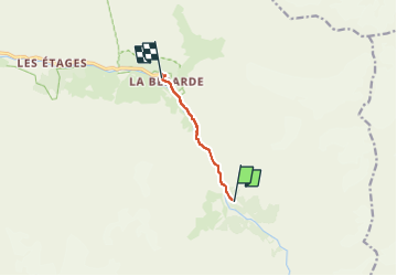
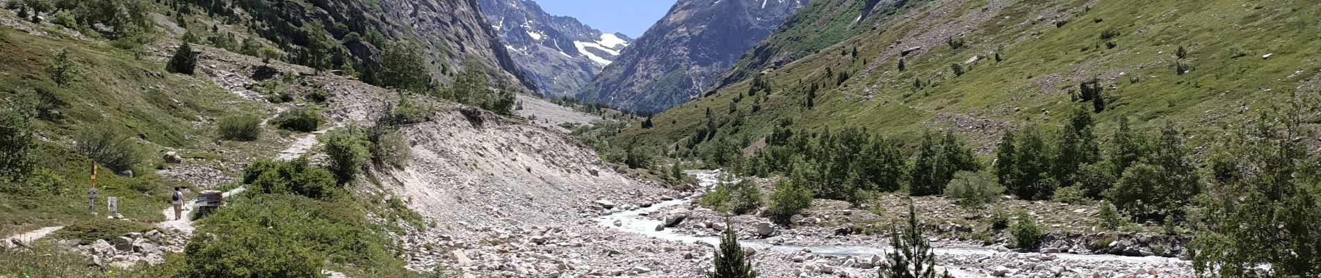
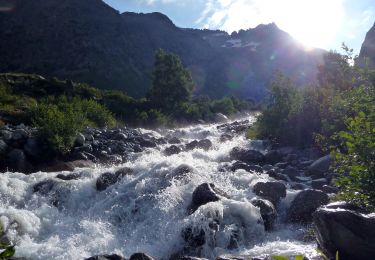
Randonnée Marche de 4,4 km à découvrir à Auvergne-Rhône-Alpes, Isère, Saint-Christophe-en-Oisans. Cette randonnée est proposée par HF89.

Description

Départ du refuge du Carrelet .
8,8 km A/R.

Profil altimétrique

Photos

Localisation

Pays :
France
Région :
Auvergne-Rhône-Alpes
Département/Province :
Isère
Commune :
Saint-Christophe-en-Oisans
Localité :
Unknown
Départ:(UTM)
287919 ; 4976051 (32T) N.

Randonnées à proximité

Randonnée Marche Saint-Christophe-en-Oisans - Malraux Refuge du Chateleret - Photo
Marche
rapako

Marche

Facile
Saint-Christophe-en-Oisans, Auvergne-Rhône-Alpes, Isère, France
12,1 km | 19,4 km-effort
5h 26min
Oui
Randonnée Marche Saint-Christophe-en-Oisans - Saint-Christophe-en-Oisans - Vallon des Etages - 6.5km 375m 3h20 - 2018 06 19 - Photo
Marche
Orcal37

Marche

Moyen
Saint-Christophe-en-Oisans, Auvergne-Rhône-Alpes, Isère, France
6,3 km | 11,2 km-effort
3h 20min
Oui
Randonnée Marche Saint-Christophe-en-Oisans - Saint-Christophe-en-Oisans - La Bérarde Cotillat (le Châtelleret) - 10.7km 390m 5h30 (45mn) - 2018 06 22 - Photo
Marche
Orcal37

Marche

Moyen
Saint-Christophe-en-Oisans, Auvergne-Rhône-Alpes, Isère, France
10,8 km | 16 km-effort
5h 30min
Oui
Randonnée Marche Saint-Christophe-en-Oisans - REFUGE DE CHATELLERET depuis LA BERARDE-07-09-2016 - Photo
Marche
RD78-38

Marche

Facile
Saint-Christophe-en-Oisans, Auvergne-Rhône-Alpes, Isère, France
14,9 km | 25 km-effort
6h 30min
Oui
Randonnée Marche Saint-Christophe-en-Oisans - MONTÉE vers LE REFUGE DU SOREILLER-08-09-2016 - Photo
Marche
RD78-38

Marche

Moyen
Saint-Christophe-en-Oisans, Auvergne-Rhône-Alpes, Isère, France
5,6 km | 16,9 km-effort
4h 5min
Non
Randonnée Marche Saint-Christophe-en-Oisans - Saint-Christophe-en-Oisans - Vallée du Vénéon les Etages - 5.2km 170m 3h15 - 2015 06 25 - Photo
Marche
Orcal37

Marche

Facile
Saint-Christophe-en-Oisans, Auvergne-Rhône-Alpes, Isère, France
5,2 km | 7,6 km-effort
3h 15min
Oui
Randonnée Marche Saint-Christophe-en-Oisans - Saint-Christophe-en-Oisans - La Bérarde Refuge du Carrelet - 7.9km 220m 2h50 - 2015 06 20 - Photo
Marche
Orcal37

Marche

Moyen
Saint-Christophe-en-Oisans, Auvergne-Rhône-Alpes, Isère, France
7,9 km | 10,8 km-effort
2h 50min
Oui
Randonnée Marche Saint-Christophe-en-Oisans - Saint-Christophe-en-Oisans - La Bérarde la Vallée du Vénéon - 13.4km 390m 4h00 (30mn) - 2014 06 08 - Photo
Marche
Orcal37

Marche

Moyen
Saint-Christophe-en-Oisans, Auvergne-Rhône-Alpes, Isère, France
13,4 km | 18,5 km-effort
4h 1min
Oui
Randonnée Marche Saint-Christophe-en-Oisans - Crique Glaciaire de Bonne Piere - Photo
Marche
franck38

Marche

Difficile
Saint-Christophe-en-Oisans, Auvergne-Rhône-Alpes, Isère, France
11,4 km | 27 km-effort
5h 27min
Oui


Fermer
Mes abonnements