![](/images/other/stat-length.png)
![Randonnée Marche Séez - Tarentaise-Lancebranlette avec retour par le Lac sans Fond - Photo](https://media.geolcdn.com/t/1900/400/ext.pjpeg?maxdim=2&url=https%3A%2F%2Fstatic1.geolcdn.com%2Fsiteimages%2Fupload%2Ffiles%2F1553511878bg_sport_marche.png)
Tarentaise-Lancebranlette avec retour par le Lac sans Fond
Maryma
Utilisateur
![Longueur](/images/other/stat-length.png)
Longueur
9,5 km
![Altitude max](https://static1.geolcdn.com/siteimages/upload/files/1508320355ic_sort_altitude_max_24dp.png)
Altitude max
2913 m
![Dénivelé positif](https://static1.geolcdn.com/siteimages/upload/files/1508320355ic_sort_den_pos_24dp.png)
Dénivelé positif
825 m
![Km-Effort](/images/other/stat-length.png)
Km-Effort
21 km
![Altitude min](https://static1.geolcdn.com/siteimages/upload/files/1508320355ic_sort_altitude_min_24dp.png)
Altitude min
2120 m
![Dénivelé négatif](https://static1.geolcdn.com/siteimages/upload/files/1508320355ic_sort_den_neg_24dp.png)
Dénivelé négatif
828 m
![Boucle](https://static1.geolcdn.com/siteimages/upload/files/16400158638029165_repeat_loop_refresh_sync_direction_icon.png)
Boucle
Oui
Date de création :
2022-08-18 13:39:12.208
Dernière modification :
2022-08-28 13:11:35.859
![Marche](https://static1.geolcdn.com/sitytour/trail-icons/101.png)
4h40
Difficulté : Difficile
![Scannez ce code QR pour ouvrir la randonnée dans l'application SityTrail](https://capi.geolives.com/qq0zvz2zws4bq2lad0pu/sitytour/trails/3358949/qr.png?size=200)
Application GPS de randonnée GRATUITE
À propos
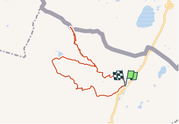
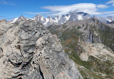
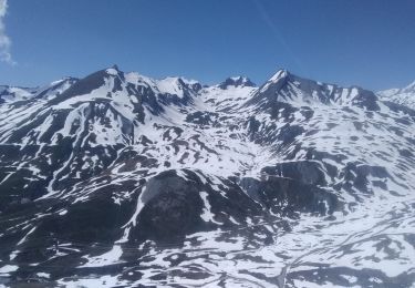
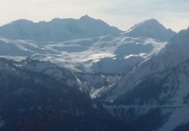
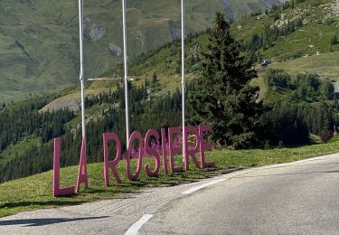
Randonnée Marche de 9,5 km à découvrir à Auvergne-Rhône-Alpes, Savoie, Séez. Cette randonnée est proposée par Maryma.
Description
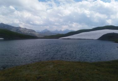
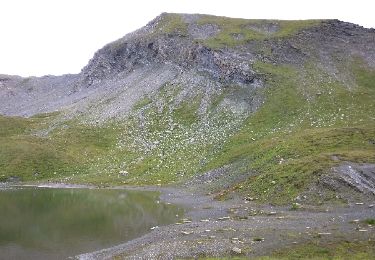
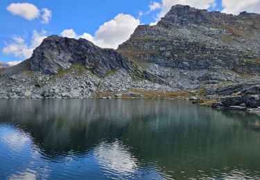
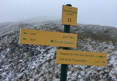
La difficulté du parcours réside dans l'ascension de Lancebranlette à partir de la bifurcation avec le lac (à 1,5 km du départ environ). Un passage très pierreux mais court.
Localisation
Pays :
France
Région :
Auvergne-Rhône-Alpes
Département/Province :
Savoie
Commune :
Séez
Localité :
Unknown
Départ:(Dec)
Départ:(UTM)
334501 ; 5059720 (32T) N.
Commentaires
Randonnées à proximité
![Randonnée Marche Séez - hospice petit saint Bernard . lac dans fond . la parciere . hospice - Photo](https://media.geolcdn.com/t/375/260/ext.jpg?maxdim=2&url=https%3A%2F%2Fmedia.geolcdn.com%2Ff%2Fcb23f3b1-848c-4f41-9bcb-bf02580d2bd3.jpg)
![Marche Marche](https://static1.geolcdn.com/sitytour/trail-icons/101.png)
hospice petit saint Bernard . lac dans fond . la parciere . hospice
Marche
Très facile
(1)
Séez,
Auvergne-Rhône-Alpes,
Savoie,
France
![](/images/other/stat-length.png)
8,9 km | 13,7 km-effort
4h 16min
![](https://static1.geolcdn.com/siteimages/upload/files/16400158638029165_repeat_loop_refresh_sync_direction_icon.png)
Oui
![Randonnée Marche Séez - Lancebranlette - Photo](https://media.geolcdn.com/t/375/260/ext.jpg?maxdim=2&url=https%3A%2F%2Fservices.sitytrail.com%2FGeolivesWS%2FDownloadMedia.ashx%3FTrailID%3D798380%26Media%3Dfix__20170729124914.jpg)
![Marche Marche](https://static1.geolcdn.com/sitytour/trail-icons/101.png)
Lancebranlette
Marche
Moyen
(1)
Séez,
Auvergne-Rhône-Alpes,
Savoie,
France
![](/images/other/stat-length.png)
10,2 km | 21 km-effort
3h 55min
![](https://static1.geolcdn.com/siteimages/upload/files/16400158638029165_repeat_loop_refresh_sync_direction_icon.png)
Oui
![Randonnée Marche Montvalezan - passage de la Louie blanche et lac du retour - Photo](https://media.geolcdn.com/t/375/260/ext.jpg?maxdim=2&url=https%3A%2F%2Fmedia.geolcdn.com%2Ff%2F473f4e21-59c1-4ed2-ae81-88697aa95ac7.jpg)
![Marche Marche](https://static1.geolcdn.com/sitytour/trail-icons/101.png)
passage de la Louie blanche et lac du retour
Marche
Difficile
Montvalezan,
Auvergne-Rhône-Alpes,
Savoie,
France
![](/images/other/stat-length.png)
13,3 km | 25 km-effort
6h 3min
![](https://static1.geolcdn.com/siteimages/upload/files/16400158638029165_repeat_loop_refresh_sync_direction_icon.png)
Oui
![Randonnée Marche Séez - lancebranlette et le lac sans fond - Photo](https://media.geolcdn.com/t/375/260/ext.jpg?maxdim=2&url=https%3A%2F%2Fmedia.geolcdn.com%2Ff%2F7ff96455-e075-478f-b097-5159a70e10f9.jpg)
![Marche Marche](https://static1.geolcdn.com/sitytour/trail-icons/101.png)
lancebranlette et le lac sans fond
Marche
Moyen
Séez,
Auvergne-Rhône-Alpes,
Savoie,
France
![](/images/other/stat-length.png)
10,3 km | 21 km-effort
5h 27min
![](https://static1.geolcdn.com/siteimages/upload/files/16400158638029165_repeat_loop_refresh_sync_direction_icon.png)
Oui
![Randonnée Ski de randonnée Séez - col du Belvédère, le Valezan - Photo](https://media.geolcdn.com/t/375/260/ext.jpg?maxdim=2&url=https%3A%2F%2Fmedia.geolcdn.com%2Ff%2Fd916e824-8a72-4541-a21a-b355921c434a.jpg)
![Ski de randonnée Ski de randonnée](https://static1.geolcdn.com/sitytour/trail-icons/503.png)
col du Belvédère, le Valezan
Ski de randonnée
Facile
Séez,
Auvergne-Rhône-Alpes,
Savoie,
France
![](/images/other/stat-length.png)
16,7 km | 33 km-effort
7h 49min
![](https://static1.geolcdn.com/siteimages/upload/files/16400158638029165_repeat_loop_refresh_sync_direction_icon.png)
Oui
![Randonnée Raquettes à neige Montvalezan - Le grand tour en raquettes du domaine skiable de la rosière - Photo](https://media.geolcdn.com/t/375/260/ext.jpg?maxdim=2&url=https%3A%2F%2Fservices.sitytrail.com%2FGeolivesWS%2FDownloadMedia.ashx%3FTrailID%3D894521%26Media%3Dfix__20180125135558.jpg)
![Raquettes à neige Raquettes à neige](https://static1.geolcdn.com/sitytour/trail-icons/504.png)
Le grand tour en raquettes du domaine skiable de la rosière
Raquettes à neige
Difficile
Montvalezan,
Auvergne-Rhône-Alpes,
Savoie,
France
![](/images/other/stat-length.png)
18,2 km | 37 km-effort
4h 46min
![](https://static1.geolcdn.com/siteimages/upload/files/16400158638029165_repeat_loop_refresh_sync_direction_icon.png)
Oui
![Randonnée Marche Montvalezan - Roc Noir -Col de la Traversette Savoie Tarentaise 2017-07-31 - Photo](https://media.geolcdn.com/t/375/260/ext.jpg?maxdim=2&url=https%3A%2F%2Fservices.sitytrail.com%2FGeolivesWS%2FDownloadMedia.ashx%3FTrailID%3D800583%26Media%3Dfix__20170731121045.jpg)
![Marche Marche](https://static1.geolcdn.com/sitytour/trail-icons/101.png)
Roc Noir -Col de la Traversette Savoie Tarentaise 2017-07-31
Marche
Moyen
Montvalezan,
Auvergne-Rhône-Alpes,
Savoie,
France
![](/images/other/stat-length.png)
12,1 km | 20 km-effort
6h 49min
![](https://static1.geolcdn.com/siteimages/upload/files/16400158638029165_repeat_loop_refresh_sync_direction_icon.png)
Oui
![Randonnée V.T.T. Montvalezan - La Rosière col du Petit St Bernard - Photo](https://media.geolcdn.com/t/375/260/ext.jpg?maxdim=2&url=https%3A%2F%2Fmedia.geolcdn.com%2Ff%2F8145ecc9-246d-4adf-acdb-32c151e15b74.jpg)
![V.T.T. V.T.T.](https://static1.geolcdn.com/sitytour/trail-icons/202.png)
La Rosière col du Petit St Bernard
V.T.T.
Moyen
Montvalezan,
Auvergne-Rhône-Alpes,
Savoie,
France
![](/images/other/stat-length.png)
16,7 km | 23 km-effort
1h 8min
![](https://static1.geolcdn.com/siteimages/upload/files/16400158638029165_repeat_loop_refresh_sync_direction_icon.png)
Oui
![Randonnée Marche Séez - Aiguille de clapper - Photo](https://media.geolcdn.com/t/375/260/ext.jpg?maxdim=2&url=https%3A%2F%2Fmedia.geolcdn.com%2Ff%2Ff8dbbb24-5730-43d5-a696-8529d93fe1c9.jpg)
![Marche Marche](https://static1.geolcdn.com/sitytour/trail-icons/101.png)
Aiguille de clapper
Marche
Facile
Séez,
Auvergne-Rhône-Alpes,
Savoie,
France
![](/images/other/stat-length.png)
5,6 km | 9,6 km-effort
2h 14min
![](https://static1.geolcdn.com/siteimages/upload/files/16400158638029165_repeat_loop_refresh_sync_direction_icon.png)
Oui