Randonnée Marche Castelnau-Durban - Losque La carrière de marbre - Photo

Losque La carrière de marbre

 Jean-Paul Raton
Jean-Paul Raton

Utilisateur

© OpenStreetMap contributors
Longueur
Longueur
3,9 km
Altitude max
Altitude max
801 m
Dénivelé positif
Dénivelé positif
162 m
Km-Effort
Km-Effort  
6,1 km
Altitude min
Altitude min
669 m
Dénivelé négatif
Dénivelé négatif
164 m
Boucle
Boucle
Oui
Date de création :
2022-10-13 13:36:27.915
Dernière modification :
2022-10-13 13:50:21.987

(0 Avis)

Marche
Marche
3h53
Difficulté : Difficile

Scannez ce code QR pour ouvrir la randonnée dans l'application SityTrail

Application GPS de randonnée GRATUITE

Logo SityTrail SityTrail

IGN / Instituts géographiques

Télécharger SityTrail sur l'App Store Télécharger SityTrail sur Google Play

Logo SityTrail SityTrail World

Le monde est à vous

Télécharger SityTrail sur l'App Store Télécharger SityTrail sur Google Play Télécharger SityTrail sur Huawei AppGallery

À propos

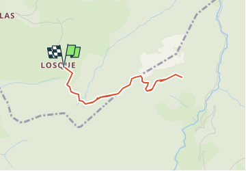
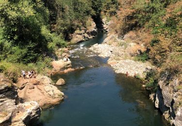
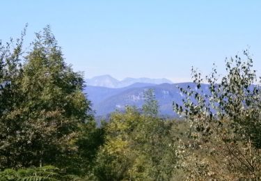
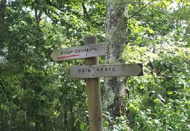
Randonnée Marche de 3,9 km à découvrir à Occitanie, Ariège, Castelnau-Durban. Cette randonnée est proposée par Jean-Paul Raton.

Profil altimétrique

Localisation

Pays :
France
Région :
Occitanie
Département/Province :
Ariège
Commune :
Castelnau-Durban
Localité :
Unknown
Départ:(UTM)
363454 ; 4759516 (31T) N.

Randonnées à proximité

Randonnée Vélo électrique Castelnau-Durban - Castelnau Durban à Niaux - Photo
Vélo électrique
jpborto

Vélo électrique

Moyen
Castelnau-Durban, Occitanie, Ariège, France
52 km | 63 km-effort
3h 8min
Non
Randonnée V.T.T. Rimont - RIMONT - Photo
V.T.T.
John09

V.T.T.

Moyen
(2)
Rimont, Occitanie, Ariège, France
13,7 km | 21 km-effort
1h 24min
Oui
Randonnée Marche Rimont - La Coue Rouge -  Rimont  - Photo
Marche
tracegps

Marche

Difficile
(1)
Rimont, Occitanie, Ariège, France
14,4 km | 23 km-effort
4h 30min
Oui
Randonnée V.T.T. La Bastide-de-Sérou - segalas  la bouiche et retour  - Photo
V.T.T.
jopost

V.T.T.

Facile
La Bastide-de-Sérou, Occitanie, Ariège, France
36 km | 42 km-effort
2h 47min
Non
Randonnée Cheval Rivèrenert - Boucle dans le Massif de l'Arize - Col de la Crouzette - Cap du Carmil - Photo
Cheval
tracegps

Cheval

Moyen
Rivèrenert, Occitanie, Ariège, France
8,7 km | 15 km-effort
1h 30min
Non
Randonnée Cheval Rivèrenert - Boucle dans le Massif de l'Arize - Pic d'Eychenne - Col de la Crouzette - Photo
Cheval
tracegps

Cheval

Moyen
Rivèrenert, Occitanie, Ariège, France
7,9 km | 13,3 km-effort
1h 0min
Non
Randonnée Marche Castelnau-Durban - Castelnau Durban , Monseron par Lazon et retour - Photo
Marche
Jean-Paul Raton

Marche

Moyen
Castelnau-Durban, Occitanie, Ariège, France
6,7 km | 10,3 km-effort
2h 20min
Oui
Randonnée Marche Durban-sur-Arize - Château de Saint Barthélemy  - Photo
Marche
Pipas31hc

Marche

Moyen
Durban-sur-Arize, Occitanie, Ariège, France
3,6 km | 5,7 km-effort
50min
Non
Randonnée Marche Durban-sur-Arize - Autour du château de Saint Barthélémy  - Photo
Marche
Pipas31hc

Marche

Moyen
Durban-sur-Arize, Occitanie, Ariège, France
13,1 km | 19,3 km-effort
3h 57min
Oui


Fermer
Mes abonnements