![](/images/other/stat-length.png)
![Randonnée Marche Rémalard en Perche - Bellou-sur-Huisne Bois Saint Georges 8 km - Photo](https://media.geolcdn.com/t/1900/400/ext.pjpeg?maxdim=2&url=https%3A%2F%2Fstatic1.geolcdn.com%2Fsiteimages%2Fupload%2Ffiles%2F1553511878bg_sport_marche.png)
Bellou-sur-Huisne Bois Saint Georges 8 km
ODDAD78
Utilisateur
![Longueur](/images/other/stat-length.png)
Longueur
8 km
![Altitude max](https://static1.geolcdn.com/siteimages/upload/files/1508320355ic_sort_altitude_max_24dp.png)
Altitude max
217 m
![Dénivelé positif](https://static1.geolcdn.com/siteimages/upload/files/1508320355ic_sort_den_pos_24dp.png)
Dénivelé positif
140 m
![Km-Effort](/images/other/stat-length.png)
Km-Effort
9,9 km
![Altitude min](https://static1.geolcdn.com/siteimages/upload/files/1508320355ic_sort_altitude_min_24dp.png)
Altitude min
120 m
![Dénivelé négatif](https://static1.geolcdn.com/siteimages/upload/files/1508320355ic_sort_den_neg_24dp.png)
Dénivelé négatif
141 m
![Boucle](https://static1.geolcdn.com/siteimages/upload/files/16400158638029165_repeat_loop_refresh_sync_direction_icon.png)
Boucle
Oui
Date de création :
2023-05-06 17:45:46.609
Dernière modification :
2023-05-22 18:45:08.704
![Marche](https://static1.geolcdn.com/sitytour/trail-icons/101.png)
2h14
Difficulté : Moyen
![Scannez ce code QR pour ouvrir la randonnée dans l'application SityTrail](https://capi.geolives.com/qq0zvz2zws4bq2lad0pu/sitytour/trails/3649355/qr.png?size=200)
Application GPS de randonnée GRATUITE
À propos
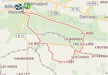
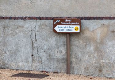
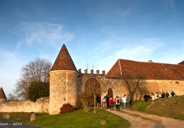
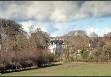
Randonnée Marche de 8 km à découvrir à Normandie, Orne, Rémalard en Perche. Cette randonnée est proposée par ODDAD78.
Description
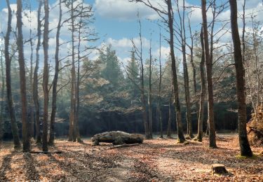
Attention : après le lieu-dit "La Forêt" le chemin est très souvent encombré de ronces. Se renseigner auprès de l'Office de Tourisme "Coeur du Perche"
Localisation
Pays :
France
Région :
Normandie
Département/Province :
Orne
Commune :
Rémalard en Perche
Localité :
Bellou-sur-Huisne
Départ:(Dec)
Départ:(UTM)
334699 ; 5365898 (31U) N.
Commentaires
Randonnées à proximité
![Randonnée Marche Rémalard en Perche - La Nymphe du Perche 5,0 Km - Photo](https://media.geolcdn.com/t/375/260/ext.jpg?maxdim=2&url=https%3A%2F%2Fmedia.geolcdn.com%2Ff%2F17cc6b0d-b494-41c7-85a0-ede1466ba884.jpg)
![Marche Marche](https://static1.geolcdn.com/sitytour/trail-icons/101.png)
La Nymphe du Perche 5,0 Km
Marche
Moyen
(1)
Rémalard en Perche,
Normandie,
Orne,
France
![](/images/other/stat-length.png)
5 km | 6,3 km-effort
1h 25min
![](https://static1.geolcdn.com/siteimages/upload/files/16400158638029165_repeat_loop_refresh_sync_direction_icon.png)
Oui
![Randonnée Marche Rémalard en Perche - Sur les terres du siège de Rémalard par Guillaume le Conquérant 9,5 km - Photo](https://media.geolcdn.com/t/375/260/ext.jpg?maxdim=2&url=https%3A%2F%2Fmedia.geolcdn.com%2Ff%2F4c079e8c-69f5-4bc5-9fc4-11ac01016a7e.jpg)
![Marche Marche](https://static1.geolcdn.com/sitytour/trail-icons/101.png)
Sur les terres du siège de Rémalard par Guillaume le Conquérant 9,5 km
Marche
Moyen
Rémalard en Perche,
Normandie,
Orne,
France
![](/images/other/stat-length.png)
9,5 km | 10,9 km-effort
2h 28min
![](https://static1.geolcdn.com/siteimages/upload/files/16400158638029165_repeat_loop_refresh_sync_direction_icon.png)
Oui
![Randonnée Marche Verrières - Les Vieilles Trognes 11 Km - Photo](https://media.geolcdn.com/t/375/260/ext.jpg?maxdim=2&url=https%3A%2F%2Fmedia.geolcdn.com%2Ff%2F2f52e433-da7f-4851-a063-0b8449b76186.jpg)
![Marche Marche](https://static1.geolcdn.com/sitytour/trail-icons/101.png)
Les Vieilles Trognes 11 Km
Marche
Difficile
Verrières,
Normandie,
Orne,
France
![](/images/other/stat-length.png)
11,4 km | 13,7 km-effort
3h 6min
![](https://static1.geolcdn.com/siteimages/upload/files/16400158638029165_repeat_loop_refresh_sync_direction_icon.png)
Oui
![Randonnée Marche Cour-Maugis sur Huisne - Maison Maugis 22.37 - Photo](https://media.geolcdn.com/t/375/260/ext.jpg?maxdim=2&url=https%3A%2F%2Fstatic1.geolcdn.com%2Fsiteimages%2Fupload%2Ffiles%2F1553511878bg_sport_marche.png)
![Marche Marche](https://static1.geolcdn.com/sitytour/trail-icons/101.png)
Maison Maugis 22.37
Marche
Moyen
(1)
Cour-Maugis sur Huisne,
Normandie,
Orne,
France
![](/images/other/stat-length.png)
22 km | 28 km-effort
Inconnu
![](https://static1.geolcdn.com/siteimages/upload/files/16400158638029165_repeat_loop_refresh_sync_direction_icon.png)
Oui
![Randonnée Marche Rémalard en Perche - Nobles Logis du Perche (Rémalard) Variante 8,3 Km - Photo](https://media.geolcdn.com/t/375/260/ext.jpg?maxdim=2&url=https%3A%2F%2Fmedia.geolcdn.com%2Ff%2F8d898521-16be-4b88-87ed-874030b976e2.jpg)
![Marche Marche](https://static1.geolcdn.com/sitytour/trail-icons/101.png)
Nobles Logis du Perche (Rémalard) Variante 8,3 Km
Marche
Moyen
Rémalard en Perche,
Normandie,
Orne,
France
![](/images/other/stat-length.png)
8,3 km | 10,2 km-effort
2h 11min
![](https://static1.geolcdn.com/siteimages/upload/files/16400158638029165_repeat_loop_refresh_sync_direction_icon.png)
Oui
![Randonnée Marche Cour-Maugis sur Huisne - Boissy-Maugis 7,6km - Photo](https://media.geolcdn.com/t/375/260/ext.jpg?maxdim=2&url=https%3A%2F%2Fmedia.geolcdn.com%2Ff%2Fb8f9aaa7-b59b-4d9c-ba02-624dc17d6137.jpg)
![Marche Marche](https://static1.geolcdn.com/sitytour/trail-icons/101.png)
Boissy-Maugis 7,6km
Marche
Facile
Cour-Maugis sur Huisne,
Normandie,
Orne,
France
![](/images/other/stat-length.png)
7,6 km | 9,5 km-effort
2h 13min
![](https://static1.geolcdn.com/siteimages/upload/files/16400158638029165_repeat_loop_refresh_sync_direction_icon.png)
Oui
![Randonnée Marche Rémalard en Perche - Le ruisseau de Pontillon 11 Km - Photo](https://media.geolcdn.com/t/375/260/ext.jpg?maxdim=2&url=https%3A%2F%2Fmedia.geolcdn.com%2Ff%2Fff177aee-f1f8-438f-adec-36e6a48cd0c9.jpg)
![Marche Marche](https://static1.geolcdn.com/sitytour/trail-icons/101.png)
Le ruisseau de Pontillon 11 Km
Marche
Moyen
Rémalard en Perche,
Normandie,
Orne,
France
![](/images/other/stat-length.png)
10,9 km | 13,5 km-effort
5h 28min
![](https://static1.geolcdn.com/siteimages/upload/files/16400158638029165_repeat_loop_refresh_sync_direction_icon.png)
Oui
![Randonnée Marche Rémalard en Perche - Nobles Logis du Perche (Rémalard) 24 Km - Photo](https://media.geolcdn.com/t/375/260/ext.jpg?maxdim=2&url=https%3A%2F%2Fmedia.geolcdn.com%2Ff%2F1e8cc532-bb5b-4a9b-8b5a-736f25271548.jpg)
![Marche Marche](https://static1.geolcdn.com/sitytour/trail-icons/101.png)
Nobles Logis du Perche (Rémalard) 24 Km
Marche
Moyen
Rémalard en Perche,
Normandie,
Orne,
France
![](/images/other/stat-length.png)
24 km | 29 km-effort
6h 14min
![](https://static1.geolcdn.com/siteimages/upload/files/16400158638029165_repeat_loop_refresh_sync_direction_icon.png)
Oui
![Randonnée Marche Cour-Maugis sur Huisne - La Clairière de Saint-Laurent 16,0 Km - Photo](https://media.geolcdn.com/t/375/260/ext.jpg?maxdim=2&url=https%3A%2F%2Fmedia.geolcdn.com%2Ff%2F5813c593-509f-42a8-97e4-39a0b1a6860f.jpg)
![Marche Marche](https://static1.geolcdn.com/sitytour/trail-icons/101.png)
La Clairière de Saint-Laurent 16,0 Km
Marche
Facile
Cour-Maugis sur Huisne,
Normandie,
Orne,
France
![](/images/other/stat-length.png)
16,1 km | 19,6 km-effort
4h 14min
![](https://static1.geolcdn.com/siteimages/upload/files/16400158638029165_repeat_loop_refresh_sync_direction_icon.png)
Oui