![](/images/other/stat-length.png)
![Randonnée Marche Saint-Hubert - Mirwart_Vieux Moulin de Mirwart_Alternative Forêt (SH29 bis) - Photo](https://media.geolcdn.com/t/1900/400/ext.pjpeg?maxdim=2&url=https%3A%2F%2Fservices.sitytrail.com%2FGeolivesWS%2FDownloadMedia.ashx%3FTrailID%3D366988%26Media%3D029a75cb-b10f-4900-87ea-e92327ef26cb.jpg)
Mirwart_Vieux Moulin de Mirwart_Alternative Forêt (SH29 bis)
La Grande Forêt de Saint-Hubert
Randonnées de la Grande Forêt de Saint-Hubert GUIDE+
![Longueur](/images/other/stat-length.png)
![Altitude max](https://static1.geolcdn.com/siteimages/upload/files/1508320355ic_sort_altitude_max_24dp.png)
![Dénivelé positif](https://static1.geolcdn.com/siteimages/upload/files/1508320355ic_sort_den_pos_24dp.png)
![Km-Effort](/images/other/stat-length.png)
![Altitude min](https://static1.geolcdn.com/siteimages/upload/files/1508320355ic_sort_altitude_min_24dp.png)
![Dénivelé négatif](https://static1.geolcdn.com/siteimages/upload/files/1508320355ic_sort_den_neg_24dp.png)
![Boucle](https://static1.geolcdn.com/siteimages/upload/files/16400158638029165_repeat_loop_refresh_sync_direction_icon.png)
![Marche](https://static1.geolcdn.com/sitytour/trail-icons/101.png)
3h04
Difficulté : Difficile
![Scannez ce code QR pour ouvrir la randonnée dans l'application SityTrail](https://capi.geolives.com/qq0zvz2zws4bq2lad0pu/sitytour/trails/366988/qr.png?size=200)
Application GPS de randonnée GRATUITE
À propos
Randonnée Marche de 10,8 km à découvrir à Wallonie, Luxembourg, Saint-Hubert. Cette randonnée est proposée par La Grande Forêt de Saint-Hubert.
Description
C'est la plus longue des quatre promenades du Domaine provincial de Mirwart.
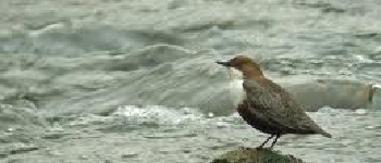
Elle permet de découvrir les richesses forestières de Mirwart.
Deux itinéraires vous sont proposés : par la route en tarmac, ou par des petits sentiers en pleine forêt.
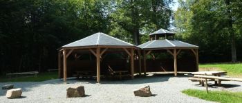
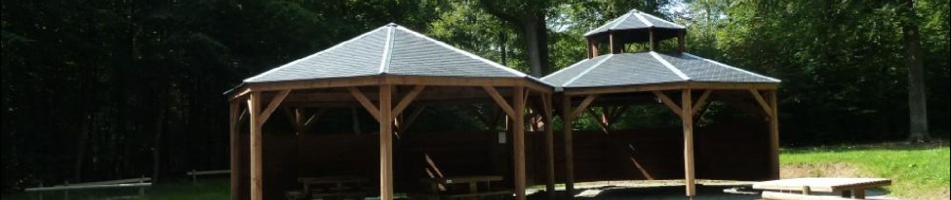
Au milieu du parcours, an lieu-dit "Biolin", une aire de repos avec kiosque et barbecues permet de faire une halte en pleine forêt. Il est également possible de bivouaquer à cet endroit. Le retour se fait en longeant les méandres sauvages de la Lomme.
Elle est équipée de 12 panneaux didactiques, sur les thèmes de la forêt, de sa faune et de sa flore.
Points d'intérêt
Localisation
Commentaires
Randonnées à proximité
![Randonnée Marche Tellin - Tellin. Natura 2000, des sites qui valent le détour ! Lx 7 - Photo](https://media.geolcdn.com/t/375/260/ext.jpg?maxdim=2&url=https%3A%2F%2Fservices.sitytrail.com%2FGeolivesWS%2FDownloadMedia.ashx%3FTrailID%3D139723%26Media%3D4b6cd866-c01c-4092-b3ae-893d48db31d3.JPG)
![Marche Marche](https://static1.geolcdn.com/sitytour/trail-icons/101.png)
Marche
![](/images/other/stat-length.png)
![](https://static1.geolcdn.com/siteimages/upload/files/16400158638029165_repeat_loop_refresh_sync_direction_icon.png)
![Randonnée Marche Saint-Hubert - Poix - Sainte-Adeline (SH15) - Photo](https://media.geolcdn.com/t/375/260/ext.jpg?maxdim=2&url=https%3A%2F%2Fservices.sitytrail.com%2FGeolivesWS%2FDownloadMedia.ashx%3FTrailID%3D334489%26Media%3Dff5c6d1c-0697-4565-9157-6580a8b8d275.jpg)
![Marche Marche](https://static1.geolcdn.com/sitytour/trail-icons/101.png)
Marche
![](/images/other/stat-length.png)
![](https://static1.geolcdn.com/siteimages/upload/files/16400158638029165_repeat_loop_refresh_sync_direction_icon.png)
![Randonnée Marche Tellin - RL-GG-13_Grupont_Poix-Saint-Hubert - Photo](https://media.geolcdn.com/t/375/260/ext.jpg?maxdim=2&url=https%3A%2F%2Fmedia.geolcdn.com%2Ff%2F5959367f-35e5-42da-bbcc-7bf6a947c3d1.jpg)
![Marche Marche](https://static1.geolcdn.com/sitytour/trail-icons/101.png)
Marche
![](/images/other/stat-length.png)
![](https://static1.geolcdn.com/siteimages/upload/files/16400158638029165_repeat_loop_refresh_sync_direction_icon.png)
![Randonnée Marche Tellin - Balade à Grupont - Photo](https://media.geolcdn.com/t/375/260/ext.jpg?maxdim=2&url=https%3A%2F%2Fservices.sitytrail.com%2FGeolivesWS%2FDownloadMedia.ashx%3FTrailID%3D963883%26Media%3D35fabe2c-0877-4435-b4f9-1ab0863175f9.jpg)
![Marche Marche](https://static1.geolcdn.com/sitytour/trail-icons/101.png)
Marche
![](/images/other/stat-length.png)
![](https://static1.geolcdn.com/siteimages/upload/files/16400158638029165_repeat_loop_refresh_sync_direction_icon.png)
![Randonnée Marche Tellin - Bure - Promenade des chapelles - Photo](https://media.geolcdn.com/t/375/260/ext.jpg?maxdim=2&url=https%3A%2F%2Fservices.sitytrail.com%2FGeolivesWS%2FDownloadMedia.ashx%3FTrailID%3D551016%26Media%3D367a68c9-5f59-4fbe-aa6c-c01d282ce6b9.jpg)
![Marche Marche](https://static1.geolcdn.com/sitytour/trail-icons/101.png)
Marche
![](/images/other/stat-length.png)
![](https://static1.geolcdn.com/siteimages/upload/files/16400158638029165_repeat_loop_refresh_sync_direction_icon.png)
![Randonnée Marche Tellin - Tellin - Promenade du trou des Lûtons - Photo](https://media.geolcdn.com/t/375/260/ext.jpg?maxdim=2&url=https%3A%2F%2Fservices.sitytrail.com%2FGeolivesWS%2FDownloadMedia.ashx%3FTrailID%3D334609%26Media%3D72f7acea-f8a9-4ab8-824e-7af5347c7927.JPG)
![Marche Marche](https://static1.geolcdn.com/sitytour/trail-icons/101.png)
Marche
![](/images/other/stat-length.png)
![](https://static1.geolcdn.com/siteimages/upload/files/16400158638029165_repeat_loop_refresh_sync_direction_icon.png)
![Randonnée A pied Tellin - Tellin - Promenade des étangs - Photo](https://media.geolcdn.com/t/375/260/ext.jpg?maxdim=2&url=https%3A%2F%2Fservices.sitytrail.com%2FGeolivesWS%2FDownloadMedia.ashx%3FTrailID%3D334608%26Media%3Da58f89aa-1898-4e28-81bb-4a136e02b6ff.jpg)
![A pied A pied](https://static1.geolcdn.com/sitytour/trail-icons/100.png)
A pied
![](/images/other/stat-length.png)
![](https://static1.geolcdn.com/siteimages/upload/files/16400158638029165_repeat_loop_refresh_sync_direction_icon.png)
![Randonnée Marche Tellin - Grupont - Promenade du bois de Machi - Photo](https://media.geolcdn.com/t/375/260/ext.jpg?maxdim=2&url=https%3A%2F%2Fservices.sitytrail.com%2FGeolivesWS%2FDownloadMedia.ashx%3FTrailID%3D334604%26Media%3Dcf0f2910-0190-4469-9f88-d94c6a2716b3.jpg)
![Marche Marche](https://static1.geolcdn.com/sitytour/trail-icons/101.png)
Marche
![](/images/other/stat-length.png)
![](https://static1.geolcdn.com/siteimages/upload/files/16400158638029165_repeat_loop_refresh_sync_direction_icon.png)
![Randonnée Marche Tellin - Bure - Promenade du Pont des Cloyes - Photo](https://media.geolcdn.com/t/375/260/ext.jpg?maxdim=2&url=https%3A%2F%2Fservices.sitytrail.com%2FGeolivesWS%2FDownloadMedia.ashx%3FTrailID%3D334602%26Media%3D8e0d2c95-f7df-4bf3-a998-440fe6cfb5b4.jpg)
![Marche Marche](https://static1.geolcdn.com/sitytour/trail-icons/101.png)
Marche
![](/images/other/stat-length.png)
![](https://static1.geolcdn.com/siteimages/upload/files/16400158638029165_repeat_loop_refresh_sync_direction_icon.png)
Chouette promenade, assez variée. Un peu trop de route sur la fin et donc circulation des voitures.
Prachtige gevarieerde wandeling door de bossen. Een unieke gevlekte ringslang gezien.
Usper
mooie wandeling door de bossen. leuke picknick plaats onderweg.
Very nice hike, steep beginning but definitely worth it.
Très belle balade. Début un peu difficile puis tout plat.
très belle promenade - vu du gibier - beaux sites naturels - beau château