![](/images/other/stat-length.png)
![Randonnée Marche Floreffe - Promenade vers Soye par bois et champs - Photo](https://media.geolcdn.com/t/1900/400/ext.pjpeg?maxdim=2&url=https%3A%2F%2Fstatic1.geolcdn.com%2Fsiteimages%2Fupload%2Ffiles%2F1553511878bg_sport_marche.png)
Promenade vers Soye par bois et champs
Desrumaux
Utilisateur GUIDE
![Longueur](/images/other/stat-length.png)
Longueur
12,3 km
![Altitude max](https://static1.geolcdn.com/siteimages/upload/files/1508320355ic_sort_altitude_max_24dp.png)
Altitude max
204 m
![Dénivelé positif](https://static1.geolcdn.com/siteimages/upload/files/1508320355ic_sort_den_pos_24dp.png)
Dénivelé positif
223 m
![Km-Effort](/images/other/stat-length.png)
Km-Effort
15,3 km
![Altitude min](https://static1.geolcdn.com/siteimages/upload/files/1508320355ic_sort_altitude_min_24dp.png)
Altitude min
88 m
![Dénivelé négatif](https://static1.geolcdn.com/siteimages/upload/files/1508320355ic_sort_den_neg_24dp.png)
Dénivelé négatif
225 m
![Boucle](https://static1.geolcdn.com/siteimages/upload/files/16400158638029165_repeat_loop_refresh_sync_direction_icon.png)
Boucle
Oui
Date de création :
2014-12-10 00:00:00.0
Dernière modification :
2022-11-04 16:15:03.942
![Marche](https://static1.geolcdn.com/sitytour/trail-icons/101.png)
3h00
Difficulté : Facile
![Scannez ce code QR pour ouvrir la randonnée dans l'application SityTrail](https://capi.geolives.com/qq0zvz2zws4bq2lad0pu/sitytour/trails/49909/qr.png?size=200)
Application GPS de randonnée GRATUITE
À propos
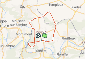
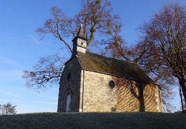
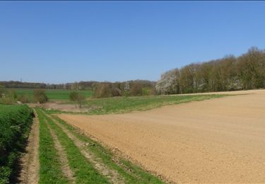
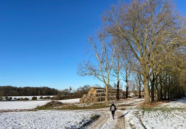
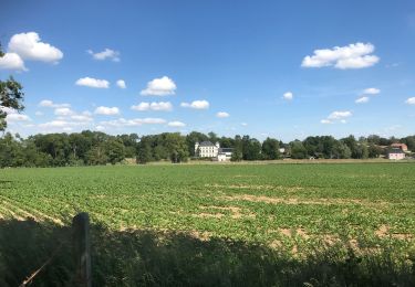
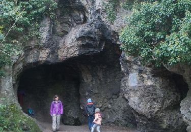
Randonnée Marche de 12,3 km à découvrir à Wallonie, Namur, Floreffe. Cette randonnée est proposée par Desrumaux.
Description
Details sur TraceGPS.com
http://www.tracegps.com/fr/parcours/circuit5810.htm
Modification du tracé dans le bois de Soye pour cause de privatisation d'un sentier
Localisation
Pays :
Belgique
Région :
Wallonie
Département/Province :
Namur
Commune :
Floreffe
Localité :
Soye
Départ:(Dec)
Départ:(UTM)
622805 ; 5590015 (31U) N.
Commentaires
Randonnées à proximité
![Randonnée Marche Floreffe - RB-Na-19_Floreffe - Photo](https://media.geolcdn.com/t/375/260/ext.jpg?maxdim=2&url=https%3A%2F%2Fmedia.geolcdn.com%2Ff%2Fc2b23cd4-6e4c-4f39-95e8-988722356b01.JPG)
![Marche Marche](https://static1.geolcdn.com/sitytour/trail-icons/101.png)
RB-Na-19_Floreffe
Marche
Très difficile
(16)
Floreffe,
Wallonie,
Namur,
Belgique
![](/images/other/stat-length.png)
19,9 km | 25 km-effort
5h 40min
![](https://static1.geolcdn.com/siteimages/upload/files/16400158638029165_repeat_loop_refresh_sync_direction_icon.png)
Oui
![Randonnée Marche Jemeppe-sur-Sambre - RF-Na-01-Onoz_Petite-boucle - Photo](https://media.geolcdn.com/t/375/260/ext.jpg?maxdim=2&url=https%3A%2F%2Fservices.sitytrail.com%2FGeolivesWS%2FDownloadMedia.ashx%3FTrailID%3D545735%26Media%3Df68c7b52-4432-4018-b01d-0bb04e06ad16.jpg)
![Marche Marche](https://static1.geolcdn.com/sitytour/trail-icons/101.png)
RF-Na-01-Onoz_Petite-boucle
Marche
Facile
(10)
Jemeppe-sur-Sambre,
Wallonie,
Namur,
Belgique
![](/images/other/stat-length.png)
7,4 km | 8,9 km-effort
1h 59min
![](https://static1.geolcdn.com/siteimages/upload/files/16400158638029165_repeat_loop_refresh_sync_direction_icon.png)
Oui
![Randonnée Marche Floreffe - RB-Na-19_Floreffe_via-racc - Photo](https://media.geolcdn.com/t/375/260/ext.jpg?maxdim=2&url=https%3A%2F%2Fmedia.geolcdn.com%2Ff%2F483ac6c3-68ad-4b42-9598-b5b3399e9eb6.JPG)
![Marche Marche](https://static1.geolcdn.com/sitytour/trail-icons/101.png)
RB-Na-19_Floreffe_via-racc
Marche
Difficile
(3)
Floreffe,
Wallonie,
Namur,
Belgique
![](/images/other/stat-length.png)
13,6 km | 17,5 km-effort
3h 58min
![](https://static1.geolcdn.com/siteimages/upload/files/16400158638029165_repeat_loop_refresh_sync_direction_icon.png)
Oui
![Randonnée Marche Floreffe - Balade à Floreffe - Photo](https://media.geolcdn.com/t/375/260/ext.jpg?maxdim=2&url=https%3A%2F%2Fservices.sitytrail.com%2FGeolivesWS%2FDownloadMedia.ashx%3FTrailID%3D236798%26Media%3Da4a2a0f8-d559-4930-aa85-d9a1040537b5.JPG)
![Marche Marche](https://static1.geolcdn.com/sitytour/trail-icons/101.png)
Balade à Floreffe
Marche
Très facile
(1)
Floreffe,
Wallonie,
Namur,
Belgique
![](/images/other/stat-length.png)
10,1 km | 14 km-effort
2h 56min
![](https://static1.geolcdn.com/siteimages/upload/files/16400158638029165_repeat_loop_refresh_sync_direction_icon.png)
Oui
![Randonnée Marche Namur - De Temploux à Suarlée - Photo](https://media.geolcdn.com/t/375/260/ext.jpg?maxdim=2&url=https%3A%2F%2Fservices.sitytrail.com%2FGeolivesWS%2FDownloadMedia.ashx%3FTrailID%3D187873%26Media%3D0f5c6b3b-618b-4553-bddc-22cf26058eb0.JPG)
![Marche Marche](https://static1.geolcdn.com/sitytour/trail-icons/101.png)
De Temploux à Suarlée
Marche
Facile
(1)
Namur,
Wallonie,
Namur,
Belgique
![](/images/other/stat-length.png)
10,7 km | 12,4 km-effort
2h 40min
![](https://static1.geolcdn.com/siteimages/upload/files/16400158638029165_repeat_loop_refresh_sync_direction_icon.png)
Oui
![Randonnée Marche Jemeppe-sur-Sambre - La petite boucle de Onoz - Photo](https://media.geolcdn.com/t/375/260/ext.jpg?maxdim=2&url=https%3A%2F%2Fmedia.geolcdn.com%2Ff%2F728a8926-dea5-48ea-8a91-8a3e4029625e.jpg)
![Marche Marche](https://static1.geolcdn.com/sitytour/trail-icons/101.png)
La petite boucle de Onoz
Marche
Facile
(3)
Jemeppe-sur-Sambre,
Wallonie,
Namur,
Belgique
![](/images/other/stat-length.png)
7 km | 8,4 km-effort
1h 57min
![](https://static1.geolcdn.com/siteimages/upload/files/16400158638029165_repeat_loop_refresh_sync_direction_icon.png)
Oui
![Randonnée Marche Floreffe - Franiere Temploux-corona2020-20Km - Photo](https://media.geolcdn.com/t/375/260/ext.jpg?maxdim=2&url=https%3A%2F%2Fmedia.geolcdn.com%2Ff%2F378c143f-9d2f-4550-82c1-b14c9446142e.JPG)
![Marche Marche](https://static1.geolcdn.com/sitytour/trail-icons/101.png)
Franiere Temploux-corona2020-20Km
Marche
Facile
(1)
Floreffe,
Wallonie,
Namur,
Belgique
![](/images/other/stat-length.png)
20 km | 24 km-effort
4h 0min
![](https://static1.geolcdn.com/siteimages/upload/files/16400158638029165_repeat_loop_refresh_sync_direction_icon.png)
Oui
![Randonnée Marche Jemeppe-sur-Sambre - RF-Na-01-Onoz_Grande-boucle - Photo](https://media.geolcdn.com/t/375/260/ext.jpg?maxdim=2&url=https%3A%2F%2Fservices.sitytrail.com%2FGeolivesWS%2FDownloadMedia.ashx%3FTrailID%3D545736%26Media%3Dca5596bc-2473-4f40-bb0a-21932020469e.jpg)
![Marche Marche](https://static1.geolcdn.com/sitytour/trail-icons/101.png)
RF-Na-01-Onoz_Grande-boucle
Marche
Moyen
(7)
Jemeppe-sur-Sambre,
Wallonie,
Namur,
Belgique
![](/images/other/stat-length.png)
8,8 km | 10,5 km-effort
2h 19min
![](https://static1.geolcdn.com/siteimages/upload/files/16400158638029165_repeat_loop_refresh_sync_direction_icon.png)
Oui
![Randonnée Marche Floreffe - Franiere - Promenade au bois de Roly - Photo](https://media.geolcdn.com/t/375/260/ext.jpg?maxdim=2&url=https%3A%2F%2Fstatic1.geolcdn.com%2Fsiteimages%2Fupload%2Ffiles%2F1553511878bg_sport_marche.png)
![Marche Marche](https://static1.geolcdn.com/sitytour/trail-icons/101.png)
Franiere - Promenade au bois de Roly
Marche
Très facile
(3)
Floreffe,
Wallonie,
Namur,
Belgique
![](/images/other/stat-length.png)
4 km | 5,3 km-effort
1h 0min
![](https://static1.geolcdn.com/siteimages/upload/files/16400158638029165_repeat_loop_refresh_sync_direction_icon.png)
Oui
tres jolie rando et sous la neige !
nickel
Super
perfect