Randonnée Moteur Saint-Étienne-la-Thillaye - pays d'Auge - Photo
 jgaramond
jgaramond

Utilisateur

© OpenStreetMap contributors
Longueur
Longueur
27 km
Altitude max
Altitude max
129 m
Dénivelé positif
Dénivelé positif
401 m
Km-Effort
Km-Effort  
32 km
Altitude min
Altitude min
7 m
Dénivelé négatif
Dénivelé négatif
417 m
Boucle
Boucle
Non
Date de création :
2014-12-10 00:00:00.0
Dernière modification :
2014-12-10 00:00:00.0

(3 Avis)

Moteur
Moteur
1h18
Difficulté : Facile

Scannez ce code QR pour ouvrir la randonnée dans l'application SityTrail

Application GPS de randonnée GRATUITE

Logo SityTrail SityTrail

IGN / Instituts géographiques

Télécharger SityTrail sur l'App Store Télécharger SityTrail sur Google Play

Logo SityTrail SityTrail World

Le monde est à vous

Télécharger SityTrail sur l'App Store Télécharger SityTrail sur Google Play Télécharger SityTrail sur Huawei AppGallery

À propos

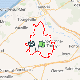
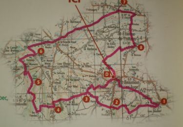
Randonnée Moteur de 27 km à découvrir à Normandie, Calvados, Saint-Étienne-la-Thillaye. Cette randonnée est proposée par jgaramond.

Profil altimétrique

Localisation

Pays :
France
Région :
Normandie
Département/Province :
Calvados
Commune :
Saint-Étienne-la-Thillaye
Localité :
Unknown
Départ:(Dec)
Départ:(UTM)
288354 ; 5462506 (31U) N.

Commentaires

Veuillez vous connecter pour laisser un commentaire ou une note


ne marche pas s' il n'y a pas de connexion à Internet


Salut tu a fait ton circuit avec quelle machine?


ne correspond à rien à virer! ,,,,,,


Randonnées à proximité

Randonnée Marche Reux - La croix de fer - Photo
Marche
neoroll44

Marche

Facile
(2)
Reux, Normandie, Calvados, France
5,7 km | 6,2 km-effort
1h 30min
Non
Randonnée Marche Beaumont-en-Auge - 2017-08-15 Rando Beaumont en Auge - Dans les pas de Laplace - Photo
Marche
jchezlemas

Marche

Facile
(1)
Beaumont-en-Auge, Normandie, Calvados, France
6,7 km | 8,9 km-effort
1h 54min
Oui
Randonnée Marche Beaumont-en-Auge - Beaumont en auge - Photo
Marche
Roulland

Marche

Facile
Beaumont-en-Auge, Normandie, Calvados, France
15,2 km | 18,1 km-effort
4h 13min
Oui
Randonnée Vélo électrique Saint-Étienne-la-Thillaye - Boucle St Étienne - Beaumont - St Hymer - Pierrefitte - Pont-Leveque  - Photo
Vélo électrique
EricVIBERT

Vélo électrique

Moyen
Saint-Étienne-la-Thillaye, Normandie, Calvados, France
24 km | 28 km-effort
1h 47min
Non
Randonnée Marche Beaumont-en-Auge - Gaumont en auge - Photo
Marche
Guilmatre

Marche

Très facile
Beaumont-en-Auge, Normandie, Calvados, France
48 km | 60 km-effort
4h 54min
Non
Randonnée Marche Beaumont-en-Auge - Beaumont St Azif - Photo
Marche
Laurent53

Marche

Moyen
Beaumont-en-Auge, Normandie, Calvados, France
19 km | 23 km-effort
5h 1min
Oui
Randonnée Marche Beaumont-en-Auge - beaumont en auge 26032017 - Photo
Marche
Laurent53

Marche

Facile
Beaumont-en-Auge, Normandie, Calvados, France
19,4 km | 24 km-effort
5h 12min
Oui
Randonnée V.T.T. Beaumont-en-Auge - Beaumont 20 km - Photo
V.T.T.
tracegps

V.T.T.

Difficile
Beaumont-en-Auge, Normandie, Calvados, France
20 km | 25 km-effort
1h 30min
Oui
Randonnée Marche Beaumont-en-Auge - Beaumont 20 km - Photo
Marche
tracegps

Marche

Très difficile
Beaumont-en-Auge, Normandie, Calvados, France
20 km | 25 km-effort
5h 0min
Oui


Fermer
Mes abonnements