![](/images/other/stat-length.png)
![Percorso Equitazione Langensoultzbach - 2023-05-07 WE CVA Langensoultzbach Disteldorf - Photo](https://media.geolcdn.com/t/1900/400/ext.pjpeg?maxdim=2&url=https%3A%2F%2Fmedia.geolcdn.com%2Ff%2Fec75f5bf-8a16-4dba-85d5-10b4834a3f57.jpg)
2023-05-07 WE CVA Langensoultzbach Disteldorf
holtzv
Utente GUIDE
![Lunghezza](/images/other/stat-length.png)
![Altitudine massima](https://static1.geolcdn.com/siteimages/upload/files/1508320355ic_sort_altitude_max_24dp.png)
![Dislivello positivo](https://static1.geolcdn.com/siteimages/upload/files/1508320355ic_sort_den_pos_24dp.png)
![Km-Effort](/images/other/stat-length.png)
![Altitudine minima](https://static1.geolcdn.com/siteimages/upload/files/1508320355ic_sort_altitude_min_24dp.png)
![Dislivello negativo](https://static1.geolcdn.com/siteimages/upload/files/1508320355ic_sort_den_neg_24dp.png)
![Boucle](https://static1.geolcdn.com/siteimages/upload/files/16400158638029165_repeat_loop_refresh_sync_direction_icon.png)
![Equitazione](https://static1.geolcdn.com/sitytour/trail-icons/301.png)
6h18
Difficoltà : Medio
![Scannerizza questo codice QR per aprire il percorso nell'applicazione SityTrail](https://capi.geolives.com/qq0zvz2zws4bq2lad0pu/sitytour/trails/3650563/qr.png?size=200)
Applicazione GPS da escursionismo GRATUITA
Chi siamo
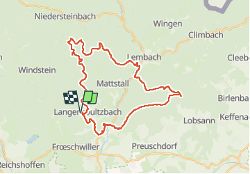
Percorso Equitazione di 35 km da scoprire a Grande Est, Basso-Reno, Langensoultzbach. Questo percorso è proposto da holtzv.
Descrizione
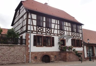
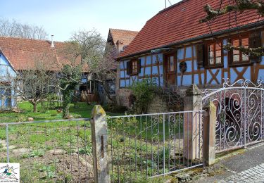
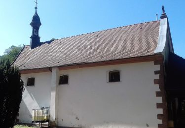
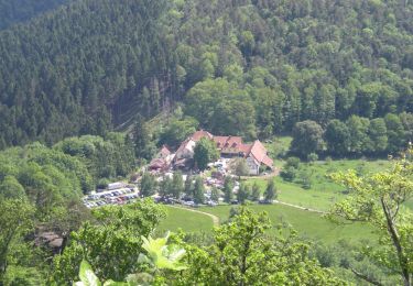
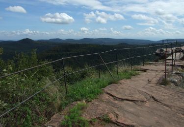
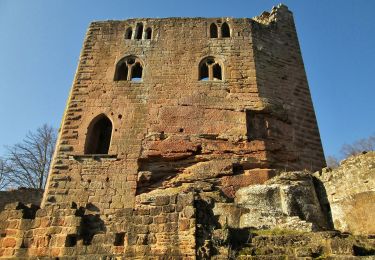
Boucle depuis le parking du stade de football de Langensoultzbach pour prendre le déjeuner à l’ancien village Disteldorf en passant par l’abri Notre-Dame du Chêne, le château du Liebfrauenberg, le Gros Chêne, le refuge du Soultzerkopf offrant une belle vue sur Soultz-sous-Forêts, Lembach et les écuries du Flecken et la M.F. de Nonnenhardt.
Localizzazione
Commenti
Percorsi nelle vicinanze
![Percorso Equitazione Langensoultzbach - 2023-05-08 WE CVA Langensoultzbach Château Schoeneck - Photo](https://media.geolcdn.com/t/375/260/ext.jpg?maxdim=2&url=https%3A%2F%2Fmedia.geolcdn.com%2Ff%2F18a8c839-8e72-4cbc-9749-f9f5619c05a4.jpg)
![Equitazione Equitazione](https://static1.geolcdn.com/sitytour/trail-icons/301.png)
Equitazione
![](/images/other/stat-length.png)
![](https://static1.geolcdn.com/siteimages/upload/files/16400158638029165_repeat_loop_refresh_sync_direction_icon.png)
![Percorso Equitazione Langensoultzbach - 2023-05-06 WE CVA Langensoultzbach Grand Wintersberg - Photo](https://media.geolcdn.com/t/375/260/ext.jpg?maxdim=2&url=https%3A%2F%2Fmedia.geolcdn.com%2Ff%2F4210c2cd-d62e-4a20-993c-f8df4c3dcc91.jpg)
![Equitazione Equitazione](https://static1.geolcdn.com/sitytour/trail-icons/301.png)
Equitazione
![](/images/other/stat-length.png)
![](https://static1.geolcdn.com/siteimages/upload/files/16400158638029165_repeat_loop_refresh_sync_direction_icon.png)
![Percorso A piedi Lembach - Anneau vert - Photo](https://media.geolcdn.com/t/375/260/ext.jpg?maxdim=2&url=https%3A%2F%2Fmedia.geolcdn.com%2Ff%2F94c60cdc-936e-47ee-9965-23e9ec9e034a.jpeg)
![A piedi A piedi](https://static1.geolcdn.com/sitytour/trail-icons/100.png)
A piedi
![](/images/other/stat-length.png)
![](https://static1.geolcdn.com/siteimages/upload/files/16400158638029165_repeat_loop_refresh_sync_direction_icon.png)
![Percorso A piedi Lembach - Rectangle bleu barré de blanc - Photo](https://media.geolcdn.com/t/375/260/ext.jpg?maxdim=2&url=https%3A%2F%2Fmedia.geolcdn.com%2Ff%2F32882194-753d-4fe2-bdd4-7cadd06c5665.jpeg)
![A piedi A piedi](https://static1.geolcdn.com/sitytour/trail-icons/100.png)
A piedi
![](/images/other/stat-length.png)
![](https://static1.geolcdn.com/siteimages/upload/files/16400158638029165_repeat_loop_refresh_sync_direction_icon.png)
![Percorso A piedi Gœrsdorf - Disque rouge - Photo](https://media.geolcdn.com/t/375/260/ext.jpg?maxdim=2&url=https%3A%2F%2Fmedia.geolcdn.com%2Ff%2Fd3987fbc-fe59-46c7-ae84-0b08ad83df79.jpeg)
![A piedi A piedi](https://static1.geolcdn.com/sitytour/trail-icons/100.png)
A piedi
![](/images/other/stat-length.png)
![](https://static1.geolcdn.com/siteimages/upload/files/16400158638029165_repeat_loop_refresh_sync_direction_icon.png)
![Percorso A piedi Lembach - Croix bleue - Photo](https://media.geolcdn.com/t/375/260/ext.jpg?maxdim=2&url=https%3A%2F%2Fmedia.geolcdn.com%2Ff%2F06df198a-1199-44ec-a8d9-2d9a150b410c.jpeg)
![A piedi A piedi](https://static1.geolcdn.com/sitytour/trail-icons/100.png)
A piedi
![](/images/other/stat-length.png)
![](https://static1.geolcdn.com/siteimages/upload/files/16400158638029165_repeat_loop_refresh_sync_direction_icon.png)
![Percorso A piedi Lembach - Rectangle rouge barré de blanc - Photo](https://media.geolcdn.com/t/375/260/ext.jpg?maxdim=2&url=https%3A%2F%2Fmedia.geolcdn.com%2Ff%2F2b23cf5f-de08-49a8-830c-5ce812af8475.jpeg)
![A piedi A piedi](https://static1.geolcdn.com/sitytour/trail-icons/100.png)
A piedi
![](/images/other/stat-length.png)
![](https://static1.geolcdn.com/siteimages/upload/files/16400158638029165_repeat_loop_refresh_sync_direction_icon.png)
![Percorso A piedi Lembach - Disque rouge - Photo](https://media.geolcdn.com/t/375/260/ext.jpg?maxdim=2&url=https%3A%2F%2Fmedia.geolcdn.com%2Ff%2F96d5bc76-0b03-4ac2-b130-0fe939d07ee1.jpeg)
![A piedi A piedi](https://static1.geolcdn.com/sitytour/trail-icons/100.png)
A piedi
![](/images/other/stat-length.png)
![](https://static1.geolcdn.com/siteimages/upload/files/16400158638029165_repeat_loop_refresh_sync_direction_icon.png)
![Percorso A piedi Langensoultzbach - Croix jaune - Photo](https://media.geolcdn.com/t/375/260/ext.jpg?maxdim=2&url=https%3A%2F%2Fmedia.geolcdn.com%2Ff%2F7362e412-d857-409e-a44e-2f2af8d84538.jpeg)
![A piedi A piedi](https://static1.geolcdn.com/sitytour/trail-icons/100.png)
A piedi
![](/images/other/stat-length.png)
![](https://static1.geolcdn.com/siteimages/upload/files/16400158638029165_repeat_loop_refresh_sync_direction_icon.png)