![](/images/other/stat-length.png)
![Tocht Mountainbike Annezin - Rando Busnes départ Annezin - Photo](https://media.geolcdn.com/t/1900/400/ext.pjpeg?maxdim=2&url=https%3A%2F%2Fservices.sitytrail.com%2FGeolivesWS%2FDownloadMedia.ashx%3FTrailID%3D102982%26Media%3D4506_1.jpg)
Rando Busnes départ Annezin
tracegps
Gebruiker
![Lengte](/images/other/stat-length.png)
Lengte
45 km
![Max. hoogte](https://static1.geolcdn.com/siteimages/upload/files/1508320355ic_sort_altitude_max_24dp.png)
Max. hoogte
83 m
![Positief hoogteverschil](https://static1.geolcdn.com/siteimages/upload/files/1508320355ic_sort_den_pos_24dp.png)
Positief hoogteverschil
270 m
![Km-Effort](/images/other/stat-length.png)
Km-Effort
49 km
![Min. hoogte](https://static1.geolcdn.com/siteimages/upload/files/1508320355ic_sort_altitude_min_24dp.png)
Min. hoogte
15 m
![Negatief hoogteverschil](https://static1.geolcdn.com/siteimages/upload/files/1508320355ic_sort_den_neg_24dp.png)
Negatief hoogteverschil
269 m
![Boucle](https://static1.geolcdn.com/siteimages/upload/files/16400158638029165_repeat_loop_refresh_sync_direction_icon.png)
Boucle
Ja
Datum van aanmaak :
2014-12-10 00:00:00.0
Laatste wijziging :
2014-12-10 00:00:00.0
![Mountainbike](https://static1.geolcdn.com/sitytour/trail-icons/202.png)
3h00
Moeilijkheid : Medium
![Scan deze QR-code om de tocht te openen in de SityTrail-applicatie](https://capi.geolives.com/qq0zvz2zws4bq2lad0pu/sitytour/trails/102982/qr.png?size=200)
Gratisgps-wandelapplicatie
Over ons
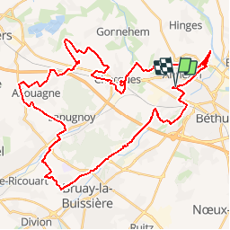
Tocht Mountainbike van 45 km beschikbaar op Hauts-de-France, Pas-de-Calais, Annezin. Deze tocht wordt voorgesteld door tracegps.
Beschrijving
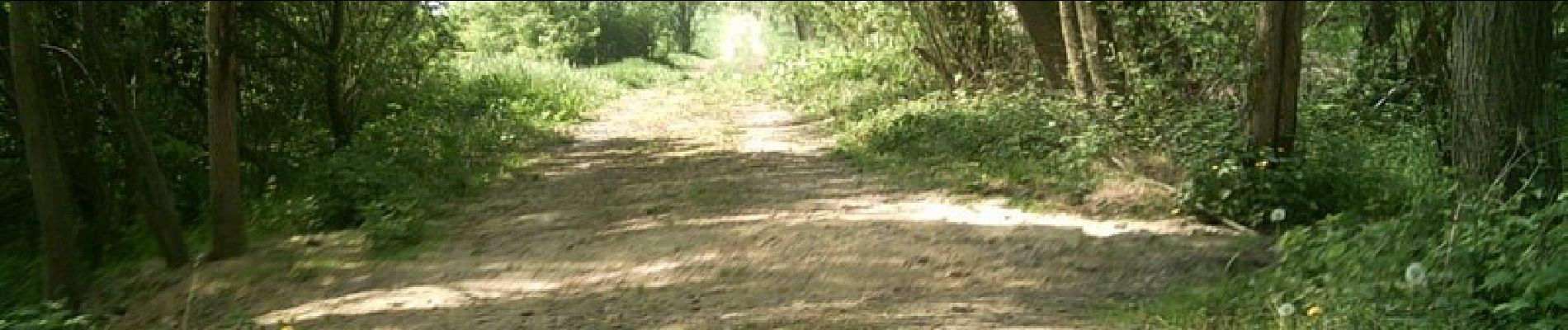
Le site Ch’ti GPS. Perds te pas avec mi ! Sympa. Chemin, Foret, Ligne de chemin de fer... Parcours de Busnes modifié Départ sur Annezin...
Plaatsbepaling
Land:
France
Regio :
Hauts-de-France
Departement/Provincie :
Pas-de-Calais
Gemeente :
Annezin
Locatie:
Unknown
Vertrek:(Dec)
Vertrek:(UTM)
472658 ; 5598183 (31U) N.
Opmerkingen
Wandeltochten in de omgeving
![Tocht Stappen Hinges - Le Rietz - Hinges - Photo](https://media.geolcdn.com/t/375/260/ext.jpg?maxdim=2&url=https%3A%2F%2Fservices.sitytrail.com%2FGeolivesWS%2FDownloadMedia.ashx%3FTrailID%3D110214%26Media%3D5469_6.jpg)
![Stappen Stappen](https://static1.geolcdn.com/sitytour/trail-icons/101.png)
Le Rietz - Hinges
Stappen
Medium
(3)
Hinges,
Hauts-de-France,
Pas-de-Calais,
France
![](/images/other/stat-length.png)
12,3 km | 13,4 km-effort
3h 0min
![](https://static1.geolcdn.com/siteimages/upload/files/16400158638029165_repeat_loop_refresh_sync_direction_icon.png)
Ja
![Tocht Stappen Béthune - Le sentier de Catorive. - Béthune - Photo](https://media.geolcdn.com/t/375/260/ext.jpg?maxdim=2&url=https%3A%2F%2Fservices.sitytrail.com%2FGeolivesWS%2FDownloadMedia.ashx%3FTrailID%3D110213%26Media%3D5468_6.jpg)
![Stappen Stappen](https://static1.geolcdn.com/sitytour/trail-icons/101.png)
Le sentier de Catorive. - Béthune
Stappen
Medium
(2)
Béthune,
Hauts-de-France,
Pas-de-Calais,
France
![](/images/other/stat-length.png)
8,3 km | 9 km-effort
2h 0min
![](https://static1.geolcdn.com/siteimages/upload/files/16400158638029165_repeat_loop_refresh_sync_direction_icon.png)
Ja
![Tocht Stappen Labourse - randonnée labourse - Photo](https://media.geolcdn.com/t/375/260/ext.jpg?maxdim=2&url=https%3A%2F%2Fmedia.geolcdn.com%2Ff%2F1a0715d7-ae08-418a-ae9d-b73bd4292578.jpg)
![Stappen Stappen](https://static1.geolcdn.com/sitytour/trail-icons/101.png)
randonnée labourse
Stappen
Zeer moeilijk
Labourse,
Hauts-de-France,
Pas-de-Calais,
France
![](/images/other/stat-length.png)
20 km | 22 km-effort
2h 45min
![](https://static1.geolcdn.com/siteimages/upload/files/16400158638029165_repeat_loop_refresh_sync_direction_icon.png)
Neen
![Tocht Stappen Béthune - Béthune - Photo](https://media.geolcdn.com/t/375/260/ext.jpg?maxdim=2&url=https%3A%2F%2Fmedia.geolcdn.com%2Ff%2Fd9061de5-0472-4700-aacc-418536d45e38.jpg)
![Stappen Stappen](https://static1.geolcdn.com/sitytour/trail-icons/101.png)
Béthune
Stappen
Heel gemakkelijk
Béthune,
Hauts-de-France,
Pas-de-Calais,
France
![](/images/other/stat-length.png)
5,6 km | 6,2 km-effort
2h 7min
![](https://static1.geolcdn.com/siteimages/upload/files/16400158638029165_repeat_loop_refresh_sync_direction_icon.png)
Ja
![Tocht Stappen Labourse - Sentier des familles - Labourse - Photo](https://media.geolcdn.com/t/375/260/ext.jpg?maxdim=2&url=https%3A%2F%2Fservices.sitytrail.com%2FGeolivesWS%2FDownloadMedia.ashx%3FTrailID%3D318036%26Media%3D17501_6.jpg)
![Stappen Stappen](https://static1.geolcdn.com/sitytour/trail-icons/101.png)
Sentier des familles - Labourse
Stappen
Gemakkelijk
Labourse,
Hauts-de-France,
Pas-de-Calais,
France
![](/images/other/stat-length.png)
5,3 km | 5,7 km-effort
1h 19min
![](https://static1.geolcdn.com/siteimages/upload/files/16400158638029165_repeat_loop_refresh_sync_direction_icon.png)
Ja
![Tocht Stappen Vaudricourt - Sentier des paysages - Vaudricourt - Photo](https://media.geolcdn.com/t/375/260/ext.jpg?maxdim=2&url=https%3A%2F%2Fservices.sitytrail.com%2FGeolivesWS%2FDownloadMedia.ashx%3FTrailID%3D318035%26Media%3D17500_6.jpg)
![Stappen Stappen](https://static1.geolcdn.com/sitytour/trail-icons/101.png)
Sentier des paysages - Vaudricourt
Stappen
Gemakkelijk
(2)
Vaudricourt,
Hauts-de-France,
Pas-de-Calais,
France
![](/images/other/stat-length.png)
6,4 km | 7 km-effort
1h 34min
![](https://static1.geolcdn.com/siteimages/upload/files/16400158638029165_repeat_loop_refresh_sync_direction_icon.png)
Ja
![Tocht Stappen Fouquières-lès-Béthune - Le sentier des 2 riviéres - Fouquières lez Béthune - Photo](https://media.geolcdn.com/t/375/260/ext.jpg?maxdim=2&url=https%3A%2F%2Fservices.sitytrail.com%2FGeolivesWS%2FDownloadMedia.ashx%3FTrailID%3D318034%26Media%3D17499_6.jpg)
![Stappen Stappen](https://static1.geolcdn.com/sitytour/trail-icons/101.png)
Le sentier des 2 riviéres - Fouquières lez Béthune
Stappen
Medium
Fouquières-lès-Béthune,
Hauts-de-France,
Pas-de-Calais,
France
![](/images/other/stat-length.png)
8,2 km | 8,9 km-effort
2h 4min
![](https://static1.geolcdn.com/siteimages/upload/files/16400158638029165_repeat_loop_refresh_sync_direction_icon.png)
Ja
![Tocht Stappen Beuvry - Le Marais de Beuvry - Photo](https://media.geolcdn.com/t/375/260/ext.jpg?maxdim=2&url=https%3A%2F%2Fservices.sitytrail.com%2FGeolivesWS%2FDownloadMedia.ashx%3FTrailID%3D317770%26Media%3D17085_6.jpg)
![Stappen Stappen](https://static1.geolcdn.com/sitytour/trail-icons/101.png)
Le Marais de Beuvry
Stappen
Medium
Beuvry,
Hauts-de-France,
Pas-de-Calais,
France
![](/images/other/stat-length.png)
12,8 km | 13,8 km-effort
3h 0min
![](https://static1.geolcdn.com/siteimages/upload/files/16400158638029165_repeat_loop_refresh_sync_direction_icon.png)
Ja
![Tocht Fiets Beuvry - Autour du beffroi (de Béthune) - Beuvry - Photo](https://media.geolcdn.com/t/375/260/ext.jpg?maxdim=2&url=https%3A%2F%2Fservices.sitytrail.com%2FGeolivesWS%2FDownloadMedia.ashx%3FTrailID%3D316848%26Media%3D15916_5.jpg)
![Fiets Fiets](https://static1.geolcdn.com/sitytour/trail-icons/200.png)
Autour du beffroi (de Béthune) - Beuvry
Fiets
Medium
Beuvry,
Hauts-de-France,
Pas-de-Calais,
France
![](/images/other/stat-length.png)
36 km | 39 km-effort
2h 0min
![](https://static1.geolcdn.com/siteimages/upload/files/16400158638029165_repeat_loop_refresh_sync_direction_icon.png)
Ja