Tocht Lopen Patay - Patay : Randonnée circuit 1 très facile - Photo

Patay : Randonnée circuit 1 très facile

 tracegps
tracegps

Gebruiker

© OpenStreetMap contributors
Lengte
Lengte
21 km
Max. hoogte
Max. hoogte
133 m
Positief hoogteverschil
99 m
Km-Effort
Km-Effort  
22 km
Min. hoogte
Min. hoogte
114 m
Negatief hoogteverschil
100 m
Boucle
Boucle
Ja
Datum van aanmaak :
2014-12-10 00:00:00.0
Laatste wijziging :
2014-12-10 00:00:00.0

(0 Bericht)

Lopen
Lopen
2h00
Moeilijkheid : Medium

Scan deze QR-code om de tocht te openen in de SityTrail-applicatie

Gratisgps-wandelapplicatie

Logo SityTrail SityTrail

IGN / Geografische instituten

SityTrail uit de App Store downloaden SityTrail uit Google Play downloaden

Logo SityTrail SityTrail World

De wereld gaat voor u open

SityTrail uit de App Store downloaden SityTrail uit Google Play downloaden SityTrail op Huawei AppGallery downloaden

Over ons

Tocht Lopen van 21 km beschikbaar op Centre-Val de Loire, Loiret, Patay. Deze tocht wordt voorgesteld door tracegps.

Beschrijving

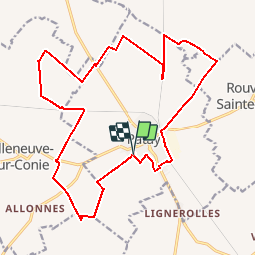
Petite randonnée VTT dans la Beauce autour de Patay. Niveau Très facile. Accès au départ : Grand Parking du centre commercial. Sécurisé et proche gendarmerie. Parcours très roulant, mélangeant chemins pédestres, singles et routes. Aucune difficulté. Chemins collants en automne - hiver.

Hoogteprofiel

Plaatsbepaling

Land:
France
Regio :
Centre-Val de Loire
Departement/Provincie :
Loiret
Gemeente :
Patay
Locatie:
Unknown
Vertrek:(Dec)
Vertrek:(UTM)
402394 ; 5322142 (31U) N.

Wandeltochten in de omgeving

Tocht Lopen Patay - Patay : Randonnée circuit 2 Facile - Photo
Lopen
tracegps

Lopen

Moeilijk
Patay, Centre-Val de Loire, Loiret, France
31 km | 33 km-effort
3h 0min
Ja
Tocht Mountainbike Patay - Patay : Randonnée circuit 2 Facile - Photo
Mountainbike
tracegps

Mountainbike

Medium
Patay, Centre-Val de Loire, Loiret, France
31 km | 33 km-effort
1h 30min
Ja
Tocht Mountainbike Patay - Patay : Randonnée circuit 1 très facile - Photo
Mountainbike
tracegps

Mountainbike

Gemakkelijk
Patay, Centre-Val de Loire, Loiret, France
21 km | 22 km-effort
1h 0min
Ja


Sluiten
Mijn abonnementen