Tocht Lopen Patay - Patay : Randonnée circuit 2 Facile - Photo

Patay : Randonnée circuit 2 Facile

 tracegps
tracegps

Gebruiker

© OpenStreetMap contributors
Lengte
Lengte
31 km
Max. hoogte
Max. hoogte
134 m
Positief hoogteverschil
147 m
Km-Effort
Km-Effort  
33 km
Min. hoogte
Min. hoogte
114 m
Negatief hoogteverschil
147 m
Boucle
Boucle
Ja
Datum van aanmaak :
2014-12-10 00:00:00.0
Laatste wijziging :
2014-12-10 00:00:00.0

(0 Bericht)

Lopen
Lopen
3h00
Moeilijkheid : Moeilijk

Scan deze QR-code om de tocht te openen in de SityTrail-applicatie

Gratisgps-wandelapplicatie

Logo SityTrail SityTrail

IGN / Geografische instituten

SityTrail uit de App Store downloaden SityTrail uit Google Play downloaden

Logo SityTrail SityTrail World

De wereld gaat voor u open

SityTrail uit de App Store downloaden SityTrail uit Google Play downloaden SityTrail op Huawei AppGallery downloaden

Over ons

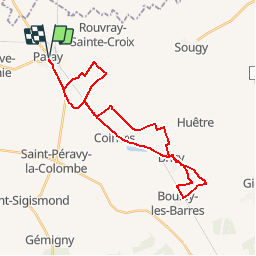
Tocht Lopen van 31 km beschikbaar op Centre-Val de Loire, Loiret, Patay. Deze tocht wordt voorgesteld door tracegps.

Beschrijving

Randonnée VTT dans la Beauce autour de Patay et Bricy. Niveau Facile. Passage près de la base aérienne. Bonne vue sur la piste d'atterrissage. Accès départ : Départ au centre du village, place de l'église avec parking. Parcours très roulant, mélangeant chemins pédestres, singles et routes. Aucune difficulté. Chemins collants en automne - hiver. Topo très facile idéal pour la découverte du VTT. Attention au passage à niveau même si les trains sont très très rares (maximum un passage par jour).

Hoogteprofiel

Plaatsbepaling

Land:
France
Regio :
Centre-Val de Loire
Departement/Provincie :
Loiret
Gemeente :
Patay
Locatie:
Unknown
Vertrek:(Dec)
Vertrek:(UTM)
402766 ; 5322435 (31U) N.

Wandeltochten in de omgeving

Tocht Mountainbike Patay - Patay : Randonnée circuit 2 Facile - Photo
Mountainbike
tracegps

Mountainbike

Medium
Patay, Centre-Val de Loire, Loiret, France
31 km | 33 km-effort
1h 30min
Ja
Tocht Lopen Patay - Patay : Randonnée circuit 1 très facile - Photo
Lopen
tracegps

Lopen

Medium
Patay, Centre-Val de Loire, Loiret, France
21 km | 22 km-effort
2h 0min
Ja
Tocht Mountainbike Patay - Patay : Randonnée circuit 1 très facile - Photo
Mountainbike
tracegps

Mountainbike

Gemakkelijk
Patay, Centre-Val de Loire, Loiret, France
21 km | 22 km-effort
1h 0min
Ja


Sluiten
Mijn abonnementen